support@meisterdrucke.com  ·  0043 4257 29415

Deutsch English Italiano Español Français Nederlands Português Svenska Polski Dansk
Search by artist, work title or style – e.g. Monet, Starry Night, Impressionism, Hokusai wave, nude. Describe the scene – e.g. green meadow, abstract with lots of red, dark oil painting, standing nude next to a tree.

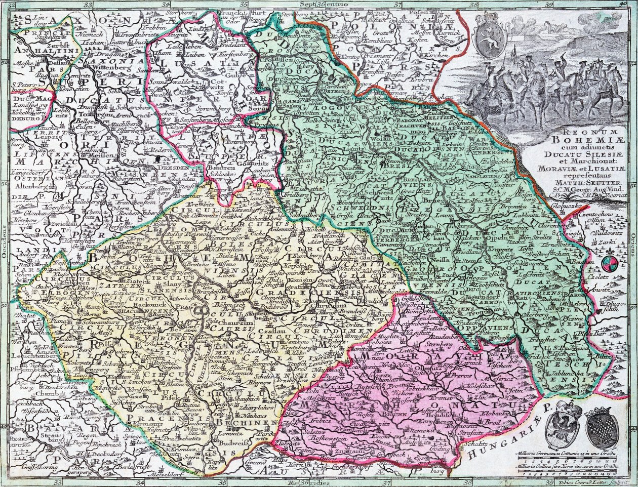
Map of Silesia, from an Atlas by Georg Matthäus Seutter

Map of Silesia, from an Atlas

(Map of Silesia, from an Atlas )


Georg Matthäus Seutter

€ 122.91
Tax-free
   Configure art print
Undated  ·  colour lithograph  ·  Image ID: 292514

Nonclassified artists  ·  Cartography

Map of Silesia, from an Atlas by Georg Matthäus Seutter. Available as an art print on canvas, photo paper, watercolor board, natural paper, or Japanese paper.
poland · germany · bohemia · europe · cartography · seven years war · silesian · Bibliotheque des Arts Decoratifs, Paris, France / Bridgeman Images
AR/3D   View in 3D / AR zu Favoriten hinzufügen   Add to favorites    Change wall color    View picture in a room

Note: Only reviews with comments are displayed. Reviews can be submitted directly after purchase in your customer account.

Configure art print

Picture Frame

Medium & Stretcher

Glass & Passepartout

Miscellaneous & Extras

 Save / compare configuration
Preview Icon

Summary

Gemälde
Veredelung
Keilrahmen
Museumslizenz

€ 122.91
(inkl. 20% MwSt)
   Add to cart

Bildschärfe: PERFEKT

If you'd like us to adjust the brightness, colors, or crop the image, we're happy to do this for you at no extra cost. Just get in touch!

Similar artworks selected for you

Map of the Austrian Empire, c. 1750 Electorate of Hanover Map of Northern Germany, from an Atlas Poland (excepted Voivodeships: Lubusz, West Pomeranian, Lower Silesian), Lithuania, Latvia, Estonia, Belarus, Ukraine (Oblast: Chernihiv, Kiev, Zhytomyr, Rivne, Volyn, Vinnytsia, Khmelnytsky, Ternopil, Lviv) Map of Poland and Lithuania Limousin, Aquitaine, Centre (surroundings Limoges), France France (Region: Nord-Pas-de-Calais, Picardy, Champagne-Ardenne, Lorraine, Île-de-France), Belgium, Netherlands (Province: Zeeland, North Brabant, Limburg), Germany (State: North Rhine-Westphalia, Rhineland-Palatinate, Saarland), Luxembourg Map of Belgium Burgundy, Rhône-Alpes, France Map of Burgundy (France) Map of the Diocese of Limoges (France) Map of Luxembourg and the diocese of Trier (Germany) Upper Hesse. Environs of Gisen Map of Bavaria (Germany) Belgium (Walloon Region), Germany (State: Rhineland-Palatinate), Luxemburg, France (Region: Lorraine, Champagne-Ardenne) Land Map of the Electorate of Brandenburg with Royal Prussian Privilege France (Region: Nord-Pas-de-Calais), large part of Belgium (except south-east), Netherlands (Zeeland, North Brabant) Map of Alsace, Baden, Sundgau and Breisgau The Kingdom of Bohemia, the Duchy of Silesia, the Margraviates of Moravia and Lusatia Hungary, Slovakia, east Romania Map of Tyrol Province (Germany) (engraving) Germany (State: Baden-Württemberg, Bavaria), Austria (State: Voralberg, Tyrol, Salzburg, Carinthia), Liechtenstein, Switzerland (Canton: Thurgau, Appenzell Ausserrhoden, Appenzell Innerrhoden, St) Map of the County of Flanders, present-day West and East Flanders in Belgium Bituricum Ducatus = Duchy of Berry Moscow, Russia - Ukraine - Lithuania - by A Map of the Province of Namur (Belgium) (engraving) Map of Bavaria, c.1695 (coloured engraving) Beauvais, France (engraving) Map of the Province of Lorraine (France) (engraving)
Show more similar artworks

Similar artworks selected for you

Map of the Austrian Empire, c. 1750 Electorate of Hanover Map of Northern Germany, from an Atlas Poland (excepted Voivodeships: Lubusz, West Pomeranian, Lower Silesian), Lithuania, Latvia, Estonia, Belarus, Ukraine (Oblast: Chernihiv, Kiev, Zhytomyr, Rivne, Volyn, Vinnytsia, Khmelnytsky, Ternopil, Lviv) Map of Poland and Lithuania Limousin, Aquitaine, Centre (surroundings Limoges), France France (Region: Nord-Pas-de-Calais, Picardy, Champagne-Ardenne, Lorraine, Île-de-France), Belgium, Netherlands (Province: Zeeland, North Brabant, Limburg), Germany (State: North Rhine-Westphalia, Rhineland-Palatinate, Saarland), Luxembourg Map of Belgium Burgundy, Rhône-Alpes, France Map of Burgundy (France) Map of the Diocese of Limoges (France) Map of Luxembourg and the diocese of Trier (Germany) Upper Hesse. Environs of Gisen Map of Bavaria (Germany) Belgium (Walloon Region), Germany (State: Rhineland-Palatinate), Luxemburg, France (Region: Lorraine, Champagne-Ardenne) Land Map of the Electorate of Brandenburg with Royal Prussian Privilege France (Region: Nord-Pas-de-Calais), large part of Belgium (except south-east), Netherlands (Zeeland, North Brabant) Map of Alsace, Baden, Sundgau and Breisgau The Kingdom of Bohemia, the Duchy of Silesia, the Margraviates of Moravia and Lusatia Hungary, Slovakia, east Romania Map of Tyrol Province (Germany) (engraving) Germany (State: Baden-Württemberg, Bavaria), Austria (State: Voralberg, Tyrol, Salzburg, Carinthia), Liechtenstein, Switzerland (Canton: Thurgau, Appenzell Ausserrhoden, Appenzell Innerrhoden, St) Map of the County of Flanders, present-day West and East Flanders in Belgium Bituricum Ducatus = Duchy of Berry Moscow, Russia - Ukraine - Lithuania - by A Map of the Province of Namur (Belgium) (engraving) Map of Bavaria, c.1695 (coloured engraving) Beauvais, France (engraving) Map of the Province of Lorraine (France) (engraving)
Show more similar artworks

More art prints by Georg Matthäus Seutter

Detailed map of the island of Martinique in the West Indies. Engraving by Matthew Seutter (1678-1757), 18th century, Chartres, Musée des Beaux-Arts Map of Silesia, from an Atlas Map of the Americas, 1744 Map of the Ottoman Empire A Map of England, 1760 Map of Alsace, Baden, Sundgau and Breisgau Map of Strasbourg, capital of Alsace Map of the Austrian Empire, c. 1750 Map of Bavaria, c.1757 Map of the world, 1744 Map of Northern Germany, from an Atlas Map of Africa, from Atlas Minor, published in Augsburg, first half of eighteenth century Map of the world and celestial planisphere Map of Florence with a Perspectival View, 1750 Map of Saint Petersburg
Show more works by Georg Matthäus Seutter

More art prints by Georg Matthäus Seutter

Detailed map of the island of Martinique in the West Indies. Engraving by Matthew Seutter (1678-1757), 18th century, Chartres, Musée des Beaux-Arts Map of Silesia, from an Atlas Map of the Americas, 1744 Map of the Ottoman Empire A Map of England, 1760 Map of Alsace, Baden, Sundgau and Breisgau Map of Strasbourg, capital of Alsace Map of the Austrian Empire, c. 1750 Map of Bavaria, c.1757 Map of the world, 1744 Map of Northern Germany, from an Atlas Map of Africa, from Atlas Minor, published in Augsburg, first half of eighteenth century Map of the world and celestial planisphere Map of Florence with a Perspectival View, 1750 Map of Saint Petersburg
Show more works by Georg Matthäus Seutter

More motifs from the category Cartography

Map of St. Petersburg Map showing the geography of the Hebrews and exhibiting the dispersion of the descendants of Noah Map of Cambridge, from Map of Regensburg, from Map of Great Britain, France and Spain, 1473 The Indian Ocean, from an Atlas of the World in 33 Maps, Venice, 1st September 1553 Map of the Siege of the Castle of Burgos, published by William Blackwood and Sons, Edinburgh and London, 1848 Maps of Galway, Dublin, Limerick, and Cork, from “Civitates Orbis Terrarum” by Georg Braun (1541-1622) and Frans Hogenberg (1535-90), c. 1573 Cyprus, Renaissance map of Europe, after Jacopo Russo, 1528 Italy and Sicily from a Renaissance map of Europe, Jacopo Russo (after), 1528 Map of the Battle of Trafalgar, published by William Blackwood and Sons, Edinburgh and London, 1848 The Battle of Jemmapes, 6th November 1792 Map of the East Indies, published 1635 in Amsterdam Ms 782 f.374v World map with Jerusalem in the centre, from Part of the Tabula Peutingeriana (Peutinger Table, Peutinger Map), an illustrated itinerarium of the road network in the Roman Empire. Detail of Italy from the Peutinger Map copy
View More from "Cartography"

More motifs from the category Cartography

Map of St. Petersburg Map showing the geography of the Hebrews and exhibiting the dispersion of the descendants of Noah Map of Cambridge, from Map of Regensburg, from Map of Great Britain, France and Spain, 1473 The Indian Ocean, from an Atlas of the World in 33 Maps, Venice, 1st September 1553 Map of the Siege of the Castle of Burgos, published by William Blackwood and Sons, Edinburgh and London, 1848 Maps of Galway, Dublin, Limerick, and Cork, from “Civitates Orbis Terrarum” by Georg Braun (1541-1622) and Frans Hogenberg (1535-90), c. 1573 Cyprus, Renaissance map of Europe, after Jacopo Russo, 1528 Italy and Sicily from a Renaissance map of Europe, Jacopo Russo (after), 1528 Map of the Battle of Trafalgar, published by William Blackwood and Sons, Edinburgh and London, 1848 The Battle of Jemmapes, 6th November 1792 Map of the East Indies, published 1635 in Amsterdam Ms 782 f.374v World map with Jerusalem in the centre, from Part of the Tabula Peutingeriana (Peutinger Table, Peutinger Map), an illustrated itinerarium of the road network in the Roman Empire. Detail of Italy from the Peutinger Map copy
View More from "Cartography"

A selection of our top sellers

The Taking of Christ Sailboats on the Wannsee Ophelia Cupid and Psyche Napoleon I Bonaparte (1769-1821) studying at the Royal Military School of Brienne (a school run by the Minimes in Aube, Champagne-Ardenne). His shadow falls on the geographical map of Europe. Illustration by Jacques Marie Gaston Onfray de Breville, known The Foxes Roe Deer and Landscape Pine Forest, left screen Adele Bloch-Bauer Kumoi-Zakura (Kumoi Cherry Trees) Death Urinating Woman on the Beach, 1908 The School of Athens, from the Stanza della Segnatura, 1509-10 Bordighera, 1884 Monkey in a Persimmon Tree, 1935
Show more artworks

A selection of our top sellers

The Taking of Christ Sailboats on the Wannsee Ophelia Cupid and Psyche Napoleon I Bonaparte (1769-1821) studying at the Royal Military School of Brienne (a school run by the Minimes in Aube, Champagne-Ardenne). His shadow falls on the geographical map of Europe. Illustration by Jacques Marie Gaston Onfray de Breville, known The Foxes Roe Deer and Landscape Pine Forest, left screen Adele Bloch-Bauer Kumoi-Zakura (Kumoi Cherry Trees) Death Urinating Woman on the Beach, 1908 The School of Athens, from the Stanza della Segnatura, 1509-10 Bordighera, 1884 Monkey in a Persimmon Tree, 1935
Show more artworks


What our customers think about us


Frequently Asked Questions about Meisterdrucke


Personalizing your art print at Meisterdrucke is simple and intuitive: Choose a frame, set the image size, pick a printing medium, and add suitable glazing or a stretcher frame. We also offer additional customization options like mats, fillets, and spacers. If you have any questions, our customer service team is ready to help you create your perfect artwork.

At Meisterdrucke, you can visualize your configured artwork directly in your own room. Simply upload a photo of your space and see how the artwork looks in it. If you're visiting us on a mobile device — phone or tablet — our augmented reality feature brings the picture to life and projects it right into your room. A unique experience that combines art and technology.

Choosing the right medium is often a matter of personal taste. To give you a better idea, we've provided some images for each medium. We also offer a sample set of all paper variants, so you can decide not just visually but by touch as well. You can order the sample set free of charge — only shipping costs apply.

Don't worry! At Meisterdrucke, we don't just process orders mechanically. Every order is manually reviewed by our team. If we spot any inconsistencies or issues with your configuration, we'll get in touch with you right away. And of course, our friendly and patient support team is always here to help you with your configuration. We'll work with you by phone or email to adjust your image so the final result is exactly what you had in mind.


Still have questions?

Are you interested in an art print from our manufactory but still unsure? Do you need advice on choosing the medium or help with the order?

Our experts are happy to assist you.

+43 4257 29415
support@meisterdrucke.com
Mo-Do: 7:00 - 16:00 | Fr: 7:00 - 13:00

Still have questions?

Are you interested in an art print from our manufactory but still unsure? Do you need advice on choosing the medium or help with the order?

Our experts are happy to assist you.

+43 4257 29415
support@meisterdrucke.com
Mo-Do: 7:00 - 16:00 | Fr: 7:00 - 13:00


Meisterdrucke

   Kärntner Strasse 46
        9586 Finkenstein am Faaker See
        Austria
        +43 4257 29415
        support@meisterdrucke.com
Other languages

                   
Erfahrungen & Bewertungen zu Meisterdrucke
Post.at DHL Express Quehenberger Cargoboard
Kaiser Franz Joseph

Meisterdrucke
Kärntner Strasse 46
9586 Finkenstein am Faaker See · Austria
+43 4257 29415 · support@meisterdrucke.com
Post.at DHL Express Quehenberger Cargoboard


(c) 2026 meisterdrucke.uk