support@meisterdrucke.com  ·  0043 4257 29415

Deutsch English Italiano Español Français Nederlands Português Svenska Polski Dansk
Search by artist, work title or style – e.g. Monet, Starry Night, Impressionism, Hokusai wave, nude. Describe the scene – e.g. green meadow, abstract with lots of red, dark oil painting, standing nude next to a tree.

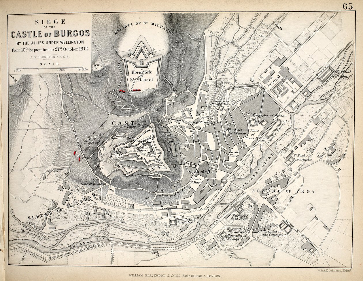
Map of the Siege of the Castle of Burgos, published by William Blackwood and Sons, Edinburgh and London, 1848 by Alexander Keith Johnston

Map of the Siege of the Castle of Burgos, published by William Blackwood and Sons, Edinburgh and London, 1848

(Map of the Siege of the Castle of Burgos, published by William Blackwood and Sons, Edinburgh und London, 1848 (hand-coloured engraving))


Alexander Keith Johnston

€ 121.41
Tax-free
   Configure art print
1848  ·  hand-coloured engraving  ·  Image ID: 144719

Nonclassified artists  ·  Cartography

Map of the Siege of the Castle of Burgos, published by William Blackwood and Sons, Edinburgh and London, 1848 by Alexander Keith Johnston. Available as an art print on canvas, photo paper, watercolor board, natural paper, or Japanese paper.
Private Collection / Bridgeman Images
AR/3D   View in 3D / AR zu Favoriten hinzufügen   Add to favorites    Change wall color    View picture in a room
0 Reviews

Configure art print

Picture Frame

Medium & Stretcher

Glass & Passepartout

Miscellaneous & Extras

 Save / compare configuration
Preview Icon

Summary

Gemälde
Veredelung
Keilrahmen
Museumslizenz

€ 121.41
(inkl. 20% MwSt)
   Add to cart

Bildschärfe: PERFEKT

If you'd like us to adjust the brightness, colors, or crop the image, we're happy to do this for you at no extra cost. Just get in touch!

Similar artworks selected for you

Map of Paris and Its Environs, Published by William Blackwood and Sons, Edinburgh & London Kingstown Harbour, East Coast of Ireland Plan of the Battle of Culloden, April 16th, 1746 Map of the Siege of Saragossa Plan for the Construction of the Coast Batteries for the Defence of Breton Harbour in 1848 Plan of the Town of Sydney, from Voyage Autour du Monde, published 1822-24 Map of the city of Lutetia, Lutetia Parisiorum, today Paris, and its surroundings, made in 1882 Map of Petersburg Map of Berlin and Cölln, 1652 Plan of the City of Lucknow, from Cassell Paris and its Environs, to illustrate the Battle of Paris, 30th March 1814 Plan of the Defence of Seetabuldee Hill, illustration from Cassell Paris and its Environs, to illustrate the Battle of Paris, 30th March, 1814, published c.1830s Map of Dusseldorf and fortified encampments Draft for Regulation of Akerselven and Loelven with Adjacent Districts Map of combat at the Battle of Lübeck, showing positions of the French, Prussian, Swedish and Danish armies Atlas 131 H. Fol. 72, Plan of Noirmoutier-en-l’Île, c. 1700 Map of the Acropolis of the 2nd city at Troy, 1884 Speculum Romanae Magnificentiae: Ancient Rome, and its Hills, from the West, 1582 Antietam Sharpsburg and vicinity. Constructed and engraved to illustrate "The war with the South" The Map is Published in (1839) and Shows Hamburg Map of Berlin, 1802 Barrackpore Park and Cantonment Plan of Jacmel Town with Fortifications Kensington in 1764 Latest Ground Plan of Berlin Statistical Description and History of the Chuguev Uhlan Regiment Plan of Delhi, 1883 Map of Petersburg
Show more similar artworks

Similar artworks selected for you

Map of Paris and Its Environs, Published by William Blackwood and Sons, Edinburgh & London Kingstown Harbour, East Coast of Ireland Plan of the Battle of Culloden, April 16th, 1746 Map of the Siege of Saragossa Plan for the Construction of the Coast Batteries for the Defence of Breton Harbour in 1848 Plan of the Town of Sydney, from Voyage Autour du Monde, published 1822-24 Map of the city of Lutetia, Lutetia Parisiorum, today Paris, and its surroundings, made in 1882 Map of Petersburg Map of Berlin and Cölln, 1652 Plan of the City of Lucknow, from Cassell Paris and its Environs, to illustrate the Battle of Paris, 30th March 1814 Plan of the Defence of Seetabuldee Hill, illustration from Cassell Paris and its Environs, to illustrate the Battle of Paris, 30th March, 1814, published c.1830s Map of Dusseldorf and fortified encampments Draft for Regulation of Akerselven and Loelven with Adjacent Districts Map of combat at the Battle of Lübeck, showing positions of the French, Prussian, Swedish and Danish armies Atlas 131 H. Fol. 72, Plan of Noirmoutier-en-l’Île, c. 1700 Map of the Acropolis of the 2nd city at Troy, 1884 Speculum Romanae Magnificentiae: Ancient Rome, and its Hills, from the West, 1582 Antietam Sharpsburg and vicinity. Constructed and engraved to illustrate "The war with the South" The Map is Published in (1839) and Shows Hamburg Map of Berlin, 1802 Barrackpore Park and Cantonment Plan of Jacmel Town with Fortifications Kensington in 1764 Latest Ground Plan of Berlin Statistical Description and History of the Chuguev Uhlan Regiment Plan of Delhi, 1883 Map of Petersburg
Show more similar artworks

More art prints by Alexander Keith Johnston

Map of the Battle of Trafalgar, published by William Blackwood and Sons, Edinburgh and London, 1848 Map of the Battle of Copenhagen, published by William Blackwood and Sons, Edinburgh and London, 1848 Map of Paris at the Outbreak of the French Revolution, 1789, published by William Blackwood and Sons, Edinburgh and London, 1848 Plan of the Battle of Cape St. Vincent, 14th February 1797, c.1830s Map of the Battle of Jena, published by William Blackwood and Sons, Edinburgh and London, 1848 Map of the Battle of Trafalgar, published by William Blackwood and Sons, Edinburgh and London, 1848 Map of the Battle of the Nile, published by William Blackwood and Sons, Edinburgh and London, 1848 Map of the Battle of Hohenlinden, published by William Blackwood and Sons, Edinburgh and London, 1848 Map of the Battle of Hanau, published by William Blackwood and Sons, Edinburgh and London, 1848 Map of the Battle of Pułtusk, published by William Blackwood and Sons, Edinburgh and London, 1848 Battle of Waterloo, 18th June 1815, Sheet 2nd, Crisis of the Battle The Battle of Trafalgar, 21st October 1805, Positions in the Battle, c.1830s Map of the Battle of Preussisch-Eylau, published by William Blackwood and Sons, Edinburgh and London, 1848 Map of the Battle of Talavera, published by William Blackwood and Sons, Edinburgh and London, 1848 (hand-coloured engraving) Map of the Battles of Smolensk and Valtellina, published by William Blackwood and Sons, Edinburgh and London, 1848
Show more works by Alexander Keith Johnston

More art prints by Alexander Keith Johnston

Map of the Battle of Trafalgar, published by William Blackwood and Sons, Edinburgh and London, 1848 Map of the Battle of Copenhagen, published by William Blackwood and Sons, Edinburgh and London, 1848 Map of Paris at the Outbreak of the French Revolution, 1789, published by William Blackwood and Sons, Edinburgh and London, 1848 Plan of the Battle of Cape St. Vincent, 14th February 1797, c.1830s Map of the Battle of Jena, published by William Blackwood and Sons, Edinburgh and London, 1848 Map of the Battle of Trafalgar, published by William Blackwood and Sons, Edinburgh and London, 1848 Map of the Battle of the Nile, published by William Blackwood and Sons, Edinburgh and London, 1848 Map of the Battle of Hohenlinden, published by William Blackwood and Sons, Edinburgh and London, 1848 Map of the Battle of Hanau, published by William Blackwood and Sons, Edinburgh and London, 1848 Map of the Battle of Pułtusk, published by William Blackwood and Sons, Edinburgh and London, 1848 Battle of Waterloo, 18th June 1815, Sheet 2nd, Crisis of the Battle The Battle of Trafalgar, 21st October 1805, Positions in the Battle, c.1830s Map of the Battle of Preussisch-Eylau, published by William Blackwood and Sons, Edinburgh and London, 1848 Map of the Battle of Talavera, published by William Blackwood and Sons, Edinburgh and London, 1848 (hand-coloured engraving) Map of the Battles of Smolensk and Valtellina, published by William Blackwood and Sons, Edinburgh and London, 1848
Show more works by Alexander Keith Johnston

More motifs from the category Cartography

Fol. 7v: Map of the North Pole, from Map of Asia, Tartaria, Japan, the Philippines and the East Indies, engraved by G. van Gouwen, c. 1690 Map of Germany, Germania Antiqua, from Map of the Island of Santo Domingo, from “Santo Domingo Past and Present” by Samuel Hazard, published 1873 Coast of North Carolina (detail) Map of Yorkshire, engraved by William Web, published 1645 A New Map of the Roman Empire, from "A Prospect of the Most Famous Parts of the World", published by Bassett and Chiswell, 1676 Map of Lisbon, from Map of the Ottoman Empire, from the ‘Atlas Novus’ Map of New France dedicated to Colbert by Duchesneau, Intendant, 1681 (detail) Map of the Battle of Trafalgar, published by William Blackwood and Sons, Edinburgh and London, 1848 Renaissance map of Europe, Jacopo Russo (after), 1528 Map of Vilnius, Lithuania, from Ayer MS 1801 Map 1: Map of lands in the Tultepec and Jaltocan regions adjacent to the Hacienda de Santa Ines, Mexico, published 1569 Map of Eastern North America: Florida to Chesapeake Bay
View More from "Cartography"

More motifs from the category Cartography

Fol. 7v: Map of the North Pole, from Map of Asia, Tartaria, Japan, the Philippines and the East Indies, engraved by G. van Gouwen, c. 1690 Map of Germany, Germania Antiqua, from Map of the Island of Santo Domingo, from “Santo Domingo Past and Present” by Samuel Hazard, published 1873 Coast of North Carolina (detail) Map of Yorkshire, engraved by William Web, published 1645 A New Map of the Roman Empire, from "A Prospect of the Most Famous Parts of the World", published by Bassett and Chiswell, 1676 Map of Lisbon, from Map of the Ottoman Empire, from the ‘Atlas Novus’ Map of New France dedicated to Colbert by Duchesneau, Intendant, 1681 (detail) Map of the Battle of Trafalgar, published by William Blackwood and Sons, Edinburgh and London, 1848 Renaissance map of Europe, Jacopo Russo (after), 1528 Map of Vilnius, Lithuania, from Ayer MS 1801 Map 1: Map of lands in the Tultepec and Jaltocan regions adjacent to the Hacienda de Santa Ines, Mexico, published 1569 Map of Eastern North America: Florida to Chesapeake Bay
View More from "Cartography"

A selection of our top sellers

Actaeon surprises the goddess Artemis (Diana) bathing with her companions The Harvesters Le Lavandou Murnau, Burggraben Street Playful Forms Girl with a Rake in Fjord Landscape The Attic Room A luncheon. The artist, his wife and the writer Otto Benzon School of Athens, from the Stanza della Segnatura, 1510-11 Ploughing in Nivernais, 1849 Cat Meadows near Greifswald Schlemmer, Oskar Chalk Paths The Stadtbahn Pavilion of the Vienna Underground Railway, design showing the exterior and a view of the railway platform, c.1894-97
Show more artworks

A selection of our top sellers

Actaeon surprises the goddess Artemis (Diana) bathing with her companions The Harvesters Le Lavandou Murnau, Burggraben Street Playful Forms Girl with a Rake in Fjord Landscape The Attic Room A luncheon. The artist, his wife and the writer Otto Benzon School of Athens, from the Stanza della Segnatura, 1510-11 Ploughing in Nivernais, 1849 Cat Meadows near Greifswald Schlemmer, Oskar Chalk Paths The Stadtbahn Pavilion of the Vienna Underground Railway, design showing the exterior and a view of the railway platform, c.1894-97
Show more artworks


What our customers think about us


Frequently Asked Questions about Meisterdrucke


Personalizing your art print at Meisterdrucke is simple and intuitive: Choose a frame, set the image size, pick a printing medium, and add suitable glazing or a stretcher frame. We also offer additional customization options like mats, fillets, and spacers. If you have any questions, our customer service team is ready to help you create your perfect artwork.

At Meisterdrucke, you can visualize your configured artwork directly in your own room. Simply upload a photo of your space and see how the artwork looks in it. If you're visiting us on a mobile device — phone or tablet — our augmented reality feature brings the picture to life and projects it right into your room. A unique experience that combines art and technology.

Choosing the right medium is often a matter of personal taste. To give you a better idea, we've provided some images for each medium. We also offer a sample set of all paper variants, so you can decide not just visually but by touch as well. You can order the sample set free of charge — only shipping costs apply.

Don't worry! At Meisterdrucke, we don't just process orders mechanically. Every order is manually reviewed by our team. If we spot any inconsistencies or issues with your configuration, we'll get in touch with you right away. And of course, our friendly and patient support team is always here to help you with your configuration. We'll work with you by phone or email to adjust your image so the final result is exactly what you had in mind.


Still have questions?

Are you interested in an art print from our manufactory but still unsure? Do you need advice on choosing the medium or help with the order?

Our experts are happy to assist you.

+43 4257 29415
support@meisterdrucke.com
Mo-Do: 7:00 - 16:00 | Fr: 7:00 - 13:00

Still have questions?

Are you interested in an art print from our manufactory but still unsure? Do you need advice on choosing the medium or help with the order?

Our experts are happy to assist you.

+43 4257 29415
support@meisterdrucke.com
Mo-Do: 7:00 - 16:00 | Fr: 7:00 - 13:00


Meisterdrucke

   Kärntner Strasse 46
        9586 Finkenstein am Faaker See
        Austria
        +43 4257 29415
        support@meisterdrucke.com
Other languages

                   
Erfahrungen & Bewertungen zu Meisterdrucke
Post.at DHL Express Quehenberger Cargoboard
Kaiser Franz Joseph

Meisterdrucke
Kärntner Strasse 46
9586 Finkenstein am Faaker See · Austria
+43 4257 29415 · support@meisterdrucke.com
Post.at DHL Express Quehenberger Cargoboard


(c) 2026 meisterdrucke.uk