support@meisterdrucke.com  ·  0043 4257 29415

Deutsch English Italiano Español Français Nederlands Português Svenska Polski Dansk
Search by artist, work title or style – e.g. Monet, Starry Night, Impressionism, Hokusai wave, nude. Describe the scene – e.g. green meadow, abstract with lots of red, dark oil painting, standing nude next to a tree.

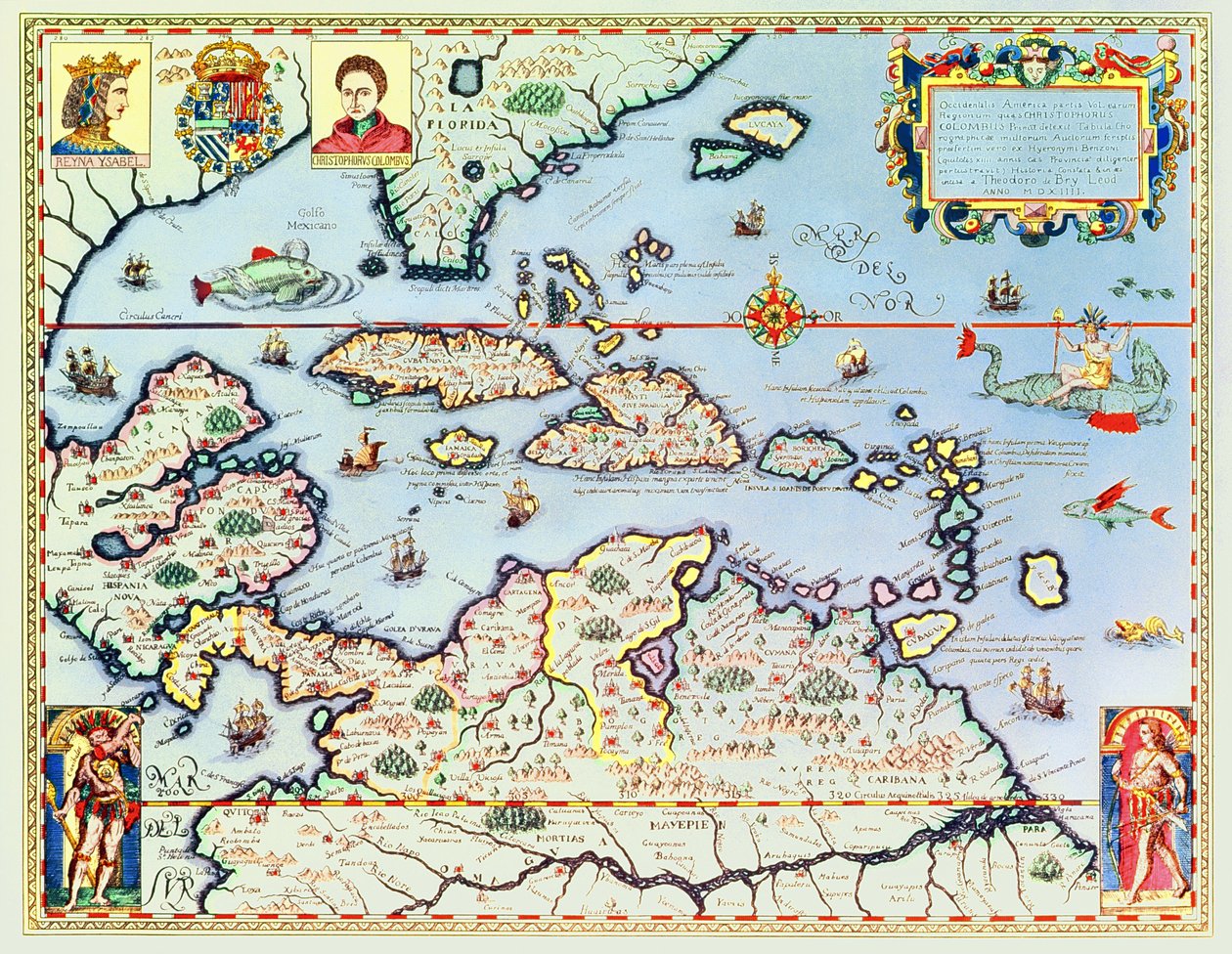
Map of the Caribbean islands and the American state of Florida by Theodore de Bry

Map of the Caribbean islands and the American state of Florida

(Map of the Caribbean islands and the American state of Florida )


Theodore de Bry

€ 121.41
Tax-free
   Configure art print
Undated  ·  coloured engraving  ·  Image ID: 101030

Nonclassified artists  ·  Cartography

Map of the Caribbean islands and the American state of Florida by Theodore de Bry. Available as an art print on canvas, photo paper, watercolor board, natural paper, or Japanese paper.
gulf of mexico · south america · central · north · island · west indies · christopher columbus · discoverer · explorer · portrait · queen isabella · spanish · jamaica · cuba · floride · amerique du sud · antilles · Private Collection / Bridgeman Images
AR/3D   View in 3D / AR zu Favoriten hinzufügen   Add to favorites    Change wall color    View picture in a room
0 Reviews

Configure art print

Picture Frame

Medium & Stretcher

Glass & Passepartout

Miscellaneous & Extras

 Save / compare configuration
Preview Icon

Summary

Gemälde
Veredelung
Keilrahmen
Museumslizenz

€ 121.41
(inkl. 20% MwSt)
   Add to cart

Bildschärfe: PERFEKT

If you'd like us to adjust the brightness, colors, or crop the image, we're happy to do this for you at no extra cost. Just get in touch!

Similar artworks selected for you

DeBry Map of Caribbean & Florida 1594 Slide of Consultation and Public Access Information Investigated from a Book and/or Review Copy Kept in the Bibliographic and Cartographic Collections Northern Europe, from Atlas of the World in thirty-three Maps Map of Zeeland, c. 1560 The famous West Indian voyage made by the English Fleet of 23 ships and barks wherein were gotten the towns of St. Iago, Sto Domingo, Cartagena and St. Augustines World map Map of India to New Guinea, c. 1570-1603 Fol. 30v Map of the Sea of Maluku, from the A faithful reproduction of Carta marina (a wall map of Scandinavia by Olaus Magnus published in 1539) Malta Eastern India with Borneo and Philippine (engraving) Map of the island of Malta Carta Marina, Original Pakistan, India, Sri Lanka, Nepal, Bhutan, Bangladesh, South China, Burma, Thailand, Laos, Vietnam, Cambodia, Malaysia, Brunei, Indonesia, The Philippines, Taiwan, South Japan Indiae Orientalis Insularumque Adiacientium Typus. Geographical map of East India and Southeast Asian territory from “Theatrum Orbis Terrarum” by Abraham Ortelius (Oertel, Ortell or Ortel). Map of Northern Europe, from Scandinavia, detail from the Carta Marina by Olaus Magnus, 1572 Geography Map of the Tartar Territory from Theatrum Orbis Terrarum by Abraham Ortelius Scandinavia, detail from the Carta Marina by Olaus Magnus, 1572 Mainland Southeast Asia, detail from a world atlas The Famous West Indian Voyage Made by the English Fleet of 23 Ships and Barks Chart of the English Channel Chart of the Mediterranean, Showing Italy and the North African Coast Dutch Trade Map of the Baltic Sea Map of Livonia Map of Livonia Die custe va Lijfflandt met de eijlanden daer beneffens Map of the Indies, from Theatrum Orbis Terrarum Map of the East Indies, published 1635 in Amsterdam From East Africa to the Tip of Ceylon
Show more similar artworks

Similar artworks selected for you

DeBry Map of Caribbean & Florida 1594 Slide of Consultation and Public Access Information Investigated from a Book and/or Review Copy Kept in the Bibliographic and Cartographic Collections Northern Europe, from Atlas of the World in thirty-three Maps Map of Zeeland, c. 1560 The famous West Indian voyage made by the English Fleet of 23 ships and barks wherein were gotten the towns of St. Iago, Sto Domingo, Cartagena and St. Augustines World map Map of India to New Guinea, c. 1570-1603 Fol. 30v Map of the Sea of Maluku, from the A faithful reproduction of Carta marina (a wall map of Scandinavia by Olaus Magnus published in 1539) Malta Eastern India with Borneo and Philippine (engraving) Map of the island of Malta Carta Marina, Original Pakistan, India, Sri Lanka, Nepal, Bhutan, Bangladesh, South China, Burma, Thailand, Laos, Vietnam, Cambodia, Malaysia, Brunei, Indonesia, The Philippines, Taiwan, South Japan Indiae Orientalis Insularumque Adiacientium Typus. Geographical map of East India and Southeast Asian territory from “Theatrum Orbis Terrarum” by Abraham Ortelius (Oertel, Ortell or Ortel). Map of Northern Europe, from Scandinavia, detail from the Carta Marina by Olaus Magnus, 1572 Geography Map of the Tartar Territory from Theatrum Orbis Terrarum by Abraham Ortelius Scandinavia, detail from the Carta Marina by Olaus Magnus, 1572 Mainland Southeast Asia, detail from a world atlas The Famous West Indian Voyage Made by the English Fleet of 23 Ships and Barks Chart of the English Channel Chart of the Mediterranean, Showing Italy and the North African Coast Dutch Trade Map of the Baltic Sea Map of Livonia Map of Livonia Die custe va Lijfflandt met de eijlanden daer beneffens Map of the Indies, from Theatrum Orbis Terrarum Map of the East Indies, published 1635 in Amsterdam From East Africa to the Tip of Ceylon
Show more similar artworks

More art prints by Theodore de Bry

Nicolaus Copernicus, Renaissance-era polymath. Interior of William Barents Admiranta Narratio.... Frontispiece (page 1), 1585-1588 Sir Walter Raleigh: The Discovery of the Large, Rich and Beautiful Empire of Guiana, from “Newe Weld un Americanische Historien”, by Johann Ludwig Gottfried, 1631 The French Help the Natives to Get Food Navigation of the French in South America in the 16th century. A whale is represented. Engraving from History of America by Theodore De Bry History of America: the explorer Christopher Columbus (1451-1506) is welcomed by the Indians on his arrival in the New World. Engraving by Théodore de Bry (1528-1598). Engraving of the 16th century Description of crimes inflicted on Indians by Spanish settlers - Scene of torture of Indians by Spanish Conquistadors. Torture on a grill, amputation of hands - Engraving by Theodore de Bry in “Narratio regionum indicarum per Hispanos quosdam devastatarum” Columbus at Hispaniola, from “The Narrative and Critical History of America”, edited by Justin Winsor, London, 1886 (later colouration) Scene of Cannibalism, from “Americae Tertia Pars...”, 1592 (colour engraving) Indian Market at Cartagena, Colombia, from ’Americae Tertia Pars V’ Description of crimes inflicted on Indians by Spanish settlers - Spaniards torturing Indians - Engraving by Theodore de Bry in “Brevísima relación de la destrucción de las Indias” by Bartolomé de las Casas (1484-1566) Gold mine in Potosi, Bolivia Cannibalism of tribes in interior of Brazil, engraving from American History by Theodore de Bry (1528-1598), Frankfurt, South America History of America: Spaniards exploit gold mines. The Indians work before the eyes of the settlers. Engraving by Theodore de Bry (1528-1598). 16th century. Private collection
Show more works by Theodore de Bry

More art prints by Theodore de Bry

Nicolaus Copernicus, Renaissance-era polymath. Interior of William Barents Admiranta Narratio.... Frontispiece (page 1), 1585-1588 Sir Walter Raleigh: The Discovery of the Large, Rich and Beautiful Empire of Guiana, from “Newe Weld un Americanische Historien”, by Johann Ludwig Gottfried, 1631 The French Help the Natives to Get Food Navigation of the French in South America in the 16th century. A whale is represented. Engraving from History of America by Theodore De Bry History of America: the explorer Christopher Columbus (1451-1506) is welcomed by the Indians on his arrival in the New World. Engraving by Théodore de Bry (1528-1598). Engraving of the 16th century Description of crimes inflicted on Indians by Spanish settlers - Scene of torture of Indians by Spanish Conquistadors. Torture on a grill, amputation of hands - Engraving by Theodore de Bry in “Narratio regionum indicarum per Hispanos quosdam devastatarum” Columbus at Hispaniola, from “The Narrative and Critical History of America”, edited by Justin Winsor, London, 1886 (later colouration) Scene of Cannibalism, from “Americae Tertia Pars...”, 1592 (colour engraving) Indian Market at Cartagena, Colombia, from ’Americae Tertia Pars V’ Description of crimes inflicted on Indians by Spanish settlers - Spaniards torturing Indians - Engraving by Theodore de Bry in “Brevísima relación de la destrucción de las Indias” by Bartolomé de las Casas (1484-1566) Gold mine in Potosi, Bolivia Cannibalism of tribes in interior of Brazil, engraving from American History by Theodore de Bry (1528-1598), Frankfurt, South America History of America: Spaniards exploit gold mines. The Indians work before the eyes of the settlers. Engraving by Theodore de Bry (1528-1598). 16th century. Private collection
Show more works by Theodore de Bry

More motifs from the category Cartography

Loggan Ms. 1288, fol. 1: The Polar Aurora, Detail of England, Ireland and Norway, from a Collection of Dutch Marine Maps, Engraving Ms. Ital. 550.0.3.15, fol. 4v-5r. Map of the Eastern Mediterranean Coast and Islands, from the „Carte Geografiche“ A New Map of the Roman Empire, from "A Prospect of the Most Famous Parts of the World", published by Bassett and Chiswell, 1676 An imaginary map of Czartorysk Ms. 988, Volume 3, fol. 39: Map of the town and citadel of Saint-Martin, Île de Ré, from the „Atlas Louis XIV“, 1683-88 Map of the Kingdom of Scotland, 17th Century, Scotia Regnum Map showing the localities of the Indian tribes of the US in 1833, illustration from India Quae Orientalis Dicitur, Et Insulae Adiacentes, map showing South-East Asia and the East Indies, published in Amsterdam, c.1635 Map of the Strait of Magellan Map of British Southern India, 1872 Map of Ireland Showing the Provinces of Ulster, Munster, Connaught and Leinster, by Johann B. Homann, c. 1730 Map of Luxembourg, from ’Civitates Orbis Terrarum’ by Georg Braun (1541-1622) and Frans Hogenberg (1535-90), c. 1572-1617 India and Malaysia, from an Atlas of the World in 33 Maps, Venice, 1st September 1553 (detail from 330955) Fol. 54v Map of Florida, from “Cosmographie Universelle”, 1555
View More from "Cartography"

More motifs from the category Cartography

Loggan Ms. 1288, fol. 1: The Polar Aurora, Detail of England, Ireland and Norway, from a Collection of Dutch Marine Maps, Engraving Ms. Ital. 550.0.3.15, fol. 4v-5r. Map of the Eastern Mediterranean Coast and Islands, from the „Carte Geografiche“ A New Map of the Roman Empire, from "A Prospect of the Most Famous Parts of the World", published by Bassett and Chiswell, 1676 An imaginary map of Czartorysk Ms. 988, Volume 3, fol. 39: Map of the town and citadel of Saint-Martin, Île de Ré, from the „Atlas Louis XIV“, 1683-88 Map of the Kingdom of Scotland, 17th Century, Scotia Regnum Map showing the localities of the Indian tribes of the US in 1833, illustration from India Quae Orientalis Dicitur, Et Insulae Adiacentes, map showing South-East Asia and the East Indies, published in Amsterdam, c.1635 Map of the Strait of Magellan Map of British Southern India, 1872 Map of Ireland Showing the Provinces of Ulster, Munster, Connaught and Leinster, by Johann B. Homann, c. 1730 Map of Luxembourg, from ’Civitates Orbis Terrarum’ by Georg Braun (1541-1622) and Frans Hogenberg (1535-90), c. 1572-1617 India and Malaysia, from an Atlas of the World in 33 Maps, Venice, 1st September 1553 (detail from 330955) Fol. 54v Map of Florida, from “Cosmographie Universelle”, 1555
View More from "Cartography"

A selection of our top sellers

The Chasseur in the Forest (A Snow-Covered Fir Forest) The Singing Man, 1928 Alpine Landscape at Sunset The Piri Reis World Map, 1513 Autumn Tree in Moving Air ("Winter Tree") Colorful in the triangle The Apple Tree The Last Supper The Terrace, Annecy Chalk Cliffs on Rügen Manuscript 69 f. 48r, Birth of Jesus, from the Book of Hours of the "Master of Jacques de Besançon" Shichiri Beach in Sagami Province Fish Magic View of El Castillo, 1844 Tulip Fields with the Rijnsburg Windmill, 1886
Show more artworks

A selection of our top sellers

The Chasseur in the Forest (A Snow-Covered Fir Forest) The Singing Man, 1928 Alpine Landscape at Sunset The Piri Reis World Map, 1513 Autumn Tree in Moving Air ("Winter Tree") Colorful in the triangle The Apple Tree The Last Supper The Terrace, Annecy Chalk Cliffs on Rügen Manuscript 69 f. 48r, Birth of Jesus, from the Book of Hours of the "Master of Jacques de Besançon" Shichiri Beach in Sagami Province Fish Magic View of El Castillo, 1844 Tulip Fields with the Rijnsburg Windmill, 1886
Show more artworks


What our customers think about us


Frequently Asked Questions about Meisterdrucke


Personalizing your art print at Meisterdrucke is simple and intuitive: Choose a frame, set the image size, pick a printing medium, and add suitable glazing or a stretcher frame. We also offer additional customization options like mats, fillets, and spacers. If you have any questions, our customer service team is ready to help you create your perfect artwork.

At Meisterdrucke, you can visualize your configured artwork directly in your own room. Simply upload a photo of your space and see how the artwork looks in it. If you're visiting us on a mobile device — phone or tablet — our augmented reality feature brings the picture to life and projects it right into your room. A unique experience that combines art and technology.

Choosing the right medium is often a matter of personal taste. To give you a better idea, we've provided some images for each medium. We also offer a sample set of all paper variants, so you can decide not just visually but by touch as well. You can order the sample set free of charge — only shipping costs apply.

Don't worry! At Meisterdrucke, we don't just process orders mechanically. Every order is manually reviewed by our team. If we spot any inconsistencies or issues with your configuration, we'll get in touch with you right away. And of course, our friendly and patient support team is always here to help you with your configuration. We'll work with you by phone or email to adjust your image so the final result is exactly what you had in mind.


Still have questions?

Are you interested in an art print from our manufactory but still unsure? Do you need advice on choosing the medium or help with the order?

Our experts are happy to assist you.

+43 4257 29415
support@meisterdrucke.com
Mo-Do: 7:00 - 16:00 | Fr: 7:00 - 13:00

Still have questions?

Are you interested in an art print from our manufactory but still unsure? Do you need advice on choosing the medium or help with the order?

Our experts are happy to assist you.

+43 4257 29415
support@meisterdrucke.com
Mo-Do: 7:00 - 16:00 | Fr: 7:00 - 13:00


Meisterdrucke

   Kärntner Strasse 46
        9586 Finkenstein am Faaker See
        Austria
        +43 4257 29415
        support@meisterdrucke.com
Other languages

                   
Erfahrungen & Bewertungen zu Meisterdrucke
Post.at DHL Express Quehenberger Cargoboard
Kaiser Franz Joseph

Meisterdrucke
Kärntner Strasse 46
9586 Finkenstein am Faaker See · Austria
+43 4257 29415 · support@meisterdrucke.com
Post.at DHL Express Quehenberger Cargoboard


(c) 2026 meisterdrucke.uk