support@meisterdrucke.com  ·  0043 4257 29415

Deutsch English Italiano Español Français Nederlands Português Svenska Polski Dansk
Search by artist, work title or style – e.g. Monet, Starry Night, Impressionism, Hokusai wave, nude. Describe the scene – e.g. green meadow, abstract with lots of red, dark oil painting, standing nude next to a tree.

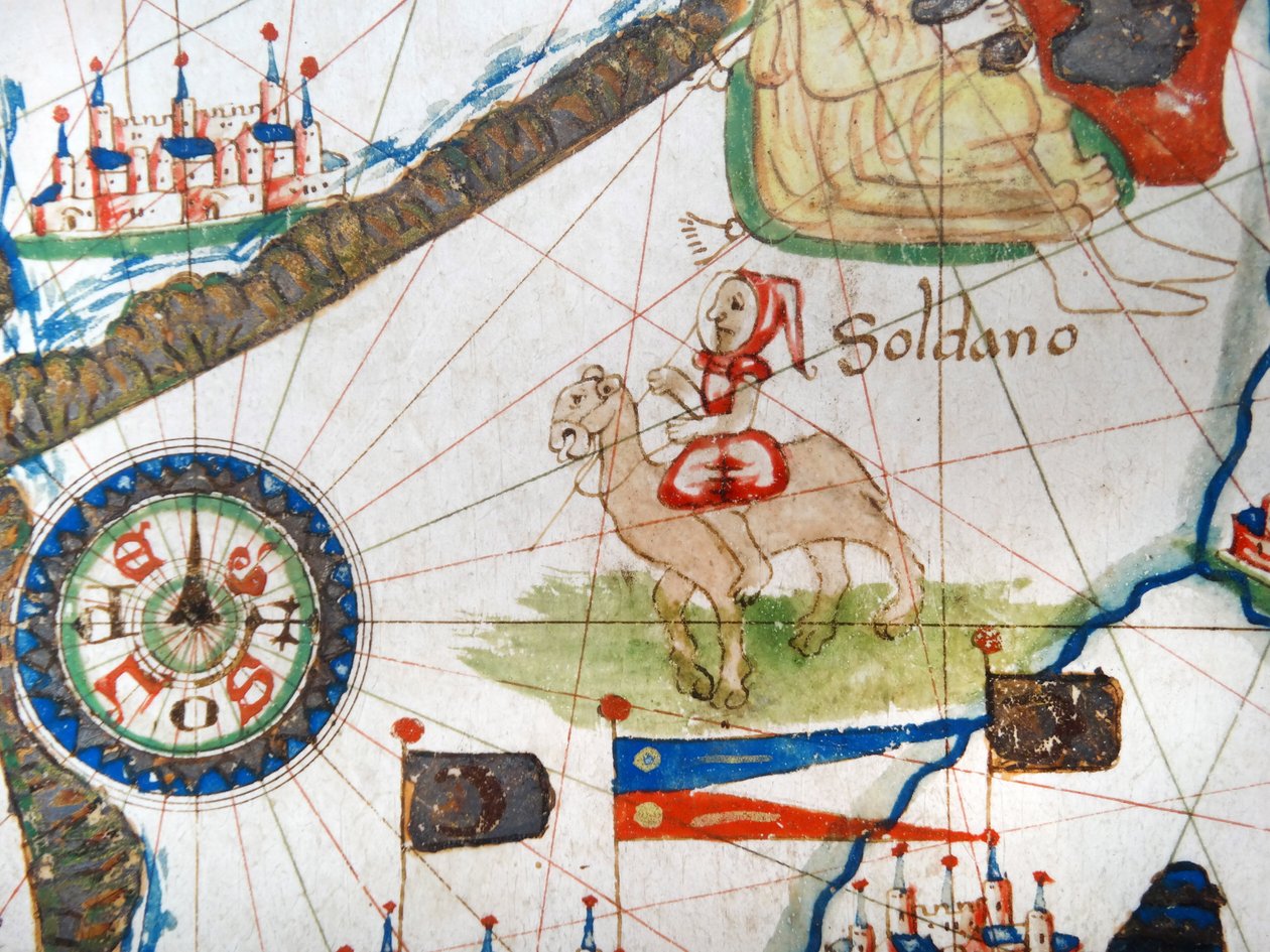
An Arab Trader on a Camel, detail from a Renaissance map of Europe, after Jacopo Russo, 1528 by Jacopo Russo

An Arab Trader on a Camel, detail from a Renaissance map of Europe, after Jacopo Russo, 1528

(An Arab Trader on a Camel, detail from a Renaissance map of Europe, Jacopo Russo (after) 1528)


Jacopo Russo

€ 127.04
Tax-free
   Configure art print
1528  ·  Image ID: 393973

Nonclassified artists  ·  Cartography

An Arab Trader on a Camel, detail from a Renaissance map of Europe, after Jacopo Russo, 1528 by Jacopo Russo. Available as an art print on canvas, photo paper, watercolor board, natural paper, or Japanese paper.
renaissance · europe · jacopo russo · detail · cartography · geography · arab · trader · camel · merchant · animal · 1520s · 16th century · - / Bridgeman Images
AR/3D   View in 3D / AR zu Favoriten hinzufügen   Add to favorites    Change wall color    View picture in a room
0 Reviews

Configure art print

Picture Frame

Medium & Stretcher

Glass & Passepartout

Miscellaneous & Extras

 Save / compare configuration
Preview Icon

Summary

Gemälde
Veredelung
Keilrahmen
Museumslizenz

€ 127.04
(inkl. 20% MwSt)
   Add to cart

Bildschärfe: PERFEKT

If you'd like us to adjust the brightness, colors, or crop the image, we're happy to do this for you at no extra cost. Just get in touch!

Similar artworks selected for you

The Balkans, from a nautical atlas of the Mediterranean and Middle East The North Coast of Africa, from a nautical atlas, 1651 (detail) Renaissance map of Europe, Jacopo Russo (after), 1528 The Maritime Cities of Genoa and Venice, from a Nautical Atlas of the Mediterranean and Middle East Representation of the King of Spain and the coasts of Europe and North Africa (portulan) Egypt and the Red Sea (detail) from a Renaissance map of Europe, 1528 The Strait of Gibraltar and North Africa marked with the flags of the Moors; to the right, the King of Mali Kanga Moussa (Kankou Moussa, or Kankan Moussa or Mansa Moussa), showing the Golden Globe. Detail of the Catalan Atlas (Catalan map), illuminated by The Cities of Marseille and Genoa with their ports, from a nautical atlas, 1651 (detail) The North African Coast, from a nautical atlas, 1651 (detail) Detail from the Catalan Atlas, Sheet 6, Showing the Western Sahara and Mansa Musa Holy Roman Emperor (detail) The Kingdom of France, from a Nautical Atlas, 1646 A Nautical Map, detail of the Gran Turco, 1564 Renaissance map of Europe, Jacopo Russo (after) 1528 Detail from the Catalan Atlas, 1375 (detail of 151844) Kingdom of France, from Portolan Atlas Consisting of Six Charts Marseille, Genoa and Venice, from a Nautical Atlas (detail) Renaissance Map of Europe, after Jacopo Russo, 1528 Renaissance map of Europe (after Jacopo Russo), 1528 The Coast of Turkey and Cyprus, from a Nautical Atlas of the Mediterranean and Middle East Provence and Northern Italy, from a Nautical Atlas Renaissance map of Europe, Jacopo Russo (after) 1528 Detail of Copy of a Catalan Map of Europe and North Africa, presented to Charles V of France in 1381 Nautical chart of the Mediterranean Sea and the Black Sea, 1440s Detail of a Catalan nautical chart (portulan) representing Asia of the 13th century Unknown Image The Coast of Tunisia and the Gulf of Gabes Nautical chart of the Mediterranean Sea and the Black Sea The Coast of Turkey and Cyprus, from a Nautical Atlas of the Mediterranean and Middle East
Show more similar artworks

More art prints by Jacopo Russo

Ms Ital 550.0.3.15 fol.2r Map of Europe, from Ms. Ital. 550.0.3.15, fol. 4v-5r. Map of the Eastern Mediterranean Coast and Islands, from the „Carte Geografiche“ Renaissance map of Europe, after Jacopo Russo, 1528 Ms Ital 550.0.3.15 fol. 6r Map of Egypt, from the „Carte Geografiche“ Detail from a Renaissance map of Europe, after Jacopo Russo, 1528 Renaissance map of Europe, after Jacopo Russo, 1528 Renaissance map of Europe, Jacopo Russo (after), 1528 England, Wales and Scotland, from a Renaissance map of Europe, after Jacopo Russo, 1528 Compass point, Renaissance map of Europe, Jacopo Russo (after), 1528 King of Poland (detail) Cyprus, Renaissance map of Europe, after Jacopo Russo, 1528 Egypt and the Red Sea, detail from a Renaissance map of Europe, Jacopo Russo (after), 1528 Ms. Ital. 550.0.3.15, fol. 4v-5r, Map of Africa and the Cape of Good Hope, from the Italy and Sicily from a Renaissance map of Europe, Jacopo Russo (after), 1528 Detail showing an African ruler from a Renaissance map of Europe, Jacopo Russo (after) 1528
Show more works by Jacopo Russo

More motifs from the category Cartography

Map of Chinese Turkestan, from “On Ancient Central-Asian Tracks” by Stein, published 1933 Map depicting plantations on the Mississippi River from Natchez to New Orleans, 1858 Map of Genoa and Florence, from Map of Aegyptus Antiqua (Ancient Egypt), drawn and engraved by Sydney Hall, c. 1826 Map of Berlin, printed by C.L. Keller, Berlin, 1890 Map showing the extent of work during the Haussmann period of development in Paris from 1854-71, 1871 Map of Visby, from ‘Civitates Orbis Terrarum’ by Georg Braun (1541-1622) and Frans Hogenberg (1535-90), c.1572-1617 Map of Candia and Corfu, from Map of Florence, 1843 and 1866 (for detail see 100311) Map of the mouth of the Chicago River, Illinois with the plan of the proposed piers for improving the harbour, 1830 The Continent of Europe, from an Atlas of the World in 33 Maps, Venice, 1st September 1553 Map showing the geography of the Hebrews and exhibiting the dispersion of the descendants of Noah Plan of the enclosed gardens and Château de Gaillon, from Map of Orléans and Bourges, from „Civitates Orbis Terrarum“ by Georg Braun (1541-1622) and Frans Hogenberg (1535-90), c. 1572 Compass point, Renaissance map of Europe, Jacopo Russo (after), 1528
View More from "Cartography"

A selection of our top sellers

After the Bath Limits of Reason, 1927. Jockey on a galloping horse, plate 627 from Animal Locomotion, 1887 Circles in a Circle, 1923 Painting from the Tomb of the Diver from the southern cemetery at Paestum, 480-470 BC One of the Family The Boxer The Harvesters Church in Cassone View of L The Embrace, 1917 Midsummer Eve Nude in an Interior Napoleon I Bonaparte (1769-1821) studying at the Royal Military School of Brienne (a school run by the Minimes in Aube, Champagne-Ardenne). His shadow falls on the geographical map of Europe. Illustration by Jacques Marie Gaston Onfray de Breville, known The Garden of Earthly Delights, 1490-1500
Show more artworks


What our customers think about us


Frequently Asked Questions about Meisterdrucke


Personalizing your art print at Meisterdrucke is simple and intuitive: Choose a frame, set the image size, pick a printing medium, and add suitable glazing or a stretcher frame. We also offer additional customization options like mats, fillets, and spacers. If you have any questions, our customer service team is ready to help you create your perfect artwork.

At Meisterdrucke, you can visualize your configured artwork directly in your own room. Simply upload a photo of your space and see how the artwork looks in it. If you're visiting us on a mobile device — phone or tablet — our augmented reality feature brings the picture to life and projects it right into your room. A unique experience that combines art and technology.

Choosing the right medium is often a matter of personal taste. To give you a better idea, we've provided some images for each medium. We also offer a sample set of all paper variants, so you can decide not just visually but by touch as well. You can order the sample set free of charge — only shipping costs apply.

Don't worry! At Meisterdrucke, we don't just process orders mechanically. Every order is manually reviewed by our team. If we spot any inconsistencies or issues with your configuration, we'll get in touch with you right away. And of course, our friendly and patient support team is always here to help you with your configuration. We'll work with you by phone or email to adjust your image so the final result is exactly what you had in mind.


Still have questions?

Are you interested in an art print from our manufactory but still unsure? Do you need advice on choosing the medium or help with the order?

Our experts are happy to assist you.

+43 4257 29415
support@meisterdrucke.com
Mo-Do: 7:00 - 16:00 | Fr: 7:00 - 13:00

Still have questions?

Are you interested in an art print from our manufactory but still unsure? Do you need advice on choosing the medium or help with the order?

Our experts are happy to assist you.

+43 4257 29415
support@meisterdrucke.com
Mo-Do: 7:00 - 16:00 | Fr: 7:00 - 13:00


Meisterdrucke

   Kärntner Strasse 46
        9586 Finkenstein am Faaker See
        Austria
        +43 4257 29415
        support@meisterdrucke.com
Other languages

                   
Erfahrungen & Bewertungen zu Meisterdrucke
Post.at DHL Express Quehenberger Cargoboard
Kaiser Franz Joseph

Meisterdrucke
Kärntner Strasse 46
9586 Finkenstein am Faaker See · Austria
+43 4257 29415 · support@meisterdrucke.com
Post.at DHL Express Quehenberger Cargoboard


(c) 2026 meisterdrucke.uk