Search by artist, work title or style – e.g. Monet, Starry Night, Impressionism, Hokusai wave, nude. Describe the scene – e.g. green meadow, abstract with lots of red, dark oil painting, standing nude next to a tree.

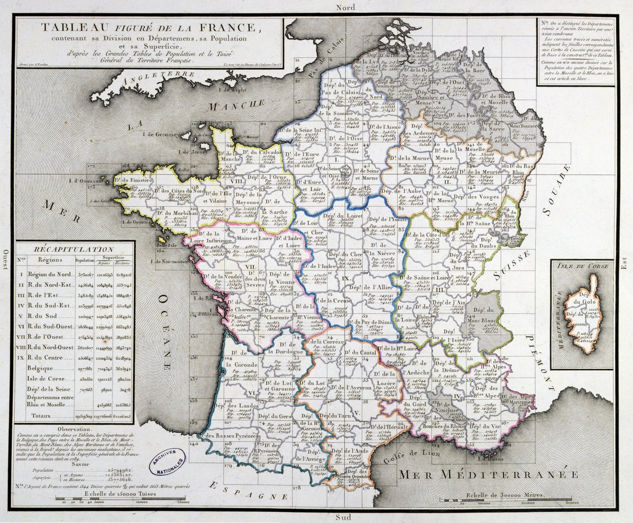
Map of France depicting the departmental divisions, 1798 by DHoudan

Map of France depicting the departmental divisions, 1798

(Map of France depicting the departmental divisions, 1798 )


DHoudan

€ 110.72
Enthält 0% MwSt.
   Configure art print
1798  ·  coloured engraving  ·  Picture ID: 362863

Nonclassified artists  ·  Cartography

Map of France depicting the departmental divisions, 1798 by DHoudan. Available as an art print on canvas, photo paper, watercolor board, uncoated paper or Japanese paper.
area · department · divided · corsica · regions · provinces · cartography · cartographical · plan · Centre Historique des Archives Nationales, Paris, France / Bridgeman Images
AR/3D   View in 3D / AR zu Favoriten hinzufügen   Add to favorites    Select wall color    View painting in a room
0 Reviews

Configure art print

Picture Frame

Medium & Stretcher

Glass & Passepartout

Miscellaneous & Extras

 Save / compare configuration
Preview Icon

Summary

Gemälde
Veredelung
Keilrahmen
Museumslizenz

€ 110.72
(inkl. 20% MwSt)
   Add to cart

Bildschärfe: PERFEKT

Should you desire adjustments to brightness and color, or a custom crop of the motif, we are happy to make these changes at no additional cost to you. Please do not hesitate to contact us.

Similar artworks selected for you

A New Geographical Pastime Exhibiting a Complete Tour Through France Respectfully Dedicated with Permission to the Right Honorable Lady Georgiana Cavendish Map of France showing plans to divide Departments, 1789 Map of France divided into Provinces Map of France as Divided into 58 Provinces Gaul divided into Roman provinces - Plate extracted from Map of the Kingdom of France France Map of France, Gallia Antique, from Map of France Fan depicting the Map of France as Divided into 9 regions, 10 metropolis and 83 departments Map of France, by Giovanni Domenico Maraldi (1709-1788) and Cesar-Francois Cassini de Thury or Cassini III (1714-1784), France Map of France on the death of Louis XIV in 1715 - engraving in Map of France at the Time of Joan of Arc Map of France under the Reign of King Louis XVI from 1774 to 1793 (Plate from Map: France Departments. Atlas of the 1950s Map of Spain and Portugal France divided into 83 departments following the decrees of the National Assembly of 1791 Map of France - in France divided into 84 departments following the decrees of the National Assembly of 1793 Kingdom of France divided into its governances New Map of France Ancient Gaul Map Map of Roads and Posts of Germany Ancient Spain Divided into Three Distinct Areas, Namely Terraconensis, Lusitania and Baetica, Engraving by G. Zuliani from Tome I of the "Newest Atlas" Map of the Iberic Peninsula, Kingdom of Portugal and Spain France by Regions, from Belgium, Netherlands, Germany, Poland (Pomeranian, West Pomeranian, Lubusz, Lower Silesian), Czech Republic (Olomouc, South Moravia, Prague, Central Bohemian, South Bohemian, Plzeň, Karlovy Vary, Ústí nad Labem, Liberec, Hradec Králové) Map of France at the times of King Charles VII and after the expulsion of the English between 1422 and 1461 (Plate from Houze Map of France
Show more similar artworks

Other motives from the category Cartography

Map of Flissinga, from Map of the known world, from Map of Atlantis, from Map of the County of Middlesex, published 1819 Map of the New Discoveries to the North of the South Seas, 1750 Map of Lower Egypt, Showing the Lines of Railway and Projected Isthmus of Suez Canal Receipt for Maple & Company Ltd Map of the Battle of Borodino, Published by William Blackwood and Sons, Edinburgh and London, 1848 Map of the Christian Constellations as Depicted by Julius Schiller, from The Celestial Atlas Map of the Christian Constellations as Depicted by Julius Schiller, from Map of the Island of Puerto Rico, 1599 Map of Virginia, discovered and described by Captain John Smith, 1606, engraved by William Hole, published 1612 Map of Venice, first half of 17th century Map of the Country between Auckland and the River Waikato, New Zealand, illustrating the War with the Natives Map of Lubeck and Hamburg, from
View More from "Cartography"

Excerpt from our top sellers

Winter, 1573 Circles in a Circle Empress Eugenie Surrounded by her Ladies-in-Waiting, 1855 Castle and Sun Venus and Mars The Pink Peach Tree, 1888 Melancholia The Waterlilies - The Clouds (right side), 1914-18 Sistine Chapel Ceiling: Creation of Adam (detail of the outstretched arms, post restoration) Sunset Over the Lake The Greifswald Market Mowing Mountain Farmers The Art of Painting Circles in a Circle Thalia, the Muse of Comedy
Show More Artworks


What our customers think about us


Frequently Asked Questions about Meisterdrucke


Personalizing your art print at Meisterdrucke is a simple and intuitive process that allows you to design an artwork exactly to your specifications: Choose a frame, determine the image size, decide on a printing medium, and add suitable glazing or a stretcher frame. We also offer customization options such as mats, fillets, and spacers. Our customer service is available to help you design your perfect artwork.

At Meisterdrucke, you have the fascinating option to visualize the artwork you configured directly in your own space. For a tailored preview, simply upload a photo of your room and let the artwork appear on it. If you visit us via a mobile device, be it a phone or tablet, our augmented reality feature brings the image to life and seamlessly projects it into your space. An experience that uniquely combines art and technology.

Choosing the medium is often a matter of personal taste. To give you a clearer idea, we have provided some images for each medium. For a holistic experience, we also offer you a sample set of all paper variants so you can make a decision not just visually but also haptically. You can take advantage of the sample set free of charge – only the shipping costs will apply. You can order the sample set directly.

Do not worry. At Meisterdrucke, we do not proceed mechanically. We manually review each order. If there are any inconsistencies or peculiarities in the configuration, we will immediately contact you. Of course, our courteous and patient support is always at your side to assist you with the configuration. Together with you, we adjust your image by phone or email so that the final result exactly meets your expectations.


Do you have any questions?

Are you interested in an art print from our manufactory but still unsure? Do you need advice on choosing the medium or help with the order?

Our experts are happy to assist you.

+43 4257 29415
support@meisterdrucke.com
Mo-Do: 7:00 - 16:00 | Fr: 7:00 - 13:00

Do you have any questions?

Are you interested in an art print from our manufactory but still unsure? Do you need advice on choosing the medium or help with the order?

Our experts are happy to assist you.

+43 4257 29415
support@meisterdrucke.com
Mo-Do: 7:00 - 16:00 | Fr: 7:00 - 13:00


Meisterdrucke

   Kärntner Strasse 46
        9586 Finkenstein am Faaker See
        Austria
        +43 4257 29415
        support@meisterdrucke.com
Other languages

                   
Erfahrungen & Bewertungen zu Meisterdrucke
Post.at DHL Express Quehenberger Cargoboard
Kaiser Franz Joseph

Meisterdrucke
Kärntner Strasse 46
9586 Finkenstein am Faaker See · Austria
+43 4257 29415 · office@meisterdrucke.com
Post.at DHL Express Quehenberger Cargoboard


Meisterdrucke 2745 Bewertungen auf ProvenExpert.com

(c) 2025 meisterdrucke.uk