support@meisterdrucke.com  ·  0043 4257 29415

Deutsch English Italiano Español Français Nederlands Português Svenska Polski Dansk
Search by artist, work title or style – e.g. Monet, Starry Night, Impressionism, Hokusai wave, nude. Describe the scene – e.g. green meadow, abstract with lots of red, dark oil painting, standing nude next to a tree.

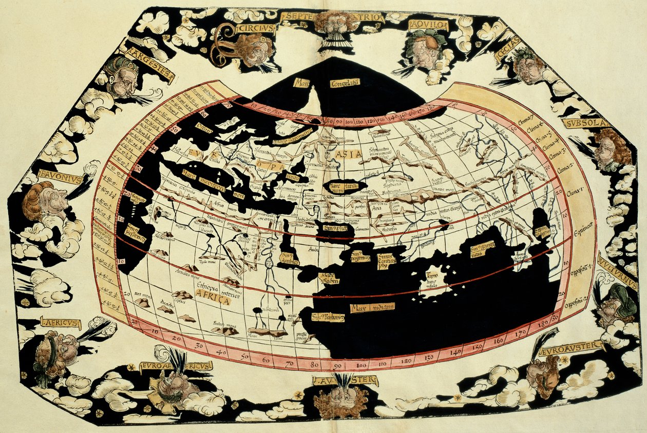
Map of the World, Based on Descriptions and Coordinates Given in “Geographia”, by Ptolemy (Claudius Ptolemaeus of Alexandria) (c. 90-168 AD) by Unbekannt Unbekannt

Map of the World, Based on Descriptions and Coordinates Given in “Geographia”, by Ptolemy (Claudius Ptolemaeus of Alexandria) (c. 90-168 AD)

(Map of the world, based on descriptions and co-ordinates given in 'Geographia', by Ptolemy (Claudius Ptolemaeus of Alexandria) (c.90-168 AD))


Unbekannt Unbekannt

€ 136.07
Tax-free
   Configure art print
Undated  ·  Image ID: 65091

Nonclassified artists  ·  Cartography

Map of the World, Based on Descriptions and Coordinates Given in “Geographia”, by Ptolemy (Claudius Ptolemaeus of Alexandria) (c. 90-168 AD) by Unbekannt Unbekannt. Available as an art print on canvas, photo paper, watercolor board, natural paper, or Japanese paper.
c02nd · chart · early cartography · geographer · cartographer · O'Shea Gallery, London, UK / Bridgeman Images
Other color versions of this image  
AR/3D   View in 3D / AR zu Favoriten hinzufügen   Add to favorites    Change wall color    View picture in a room

Note: Only reviews with comments are displayed. Reviews can be submitted directly after purchase in your customer account.

Configure art print

Picture Frame

Medium & Stretcher

Glass & Passepartout

Miscellaneous & Extras

 Save / compare configuration
Preview Icon

Summary

Gemälde
Veredelung
Keilrahmen
Museumslizenz

€ 136.07
(inkl. 20% MwSt)
   Add to cart

Bildschärfe: PERFEKT

If you'd like us to adjust the brightness, colors, or crop the image, we're happy to do this for you at no extra cost. Just get in touch!

Similar artworks selected for you

A World Map as Written Down by Ptolemy (Typus Orbis Descriptione Ptolemaei) by Laurent Fries from Gaspar Trechsel The First Edition of Ptolemy Printed in Germany, and the First with Woodcut Maps. Original Binding. Map of the world, based on descriptions and coordinates given in Map of the world Map of the World, Based on Descriptions and Co-ordinates Given in Map of the world, based on descriptions and co-ordinates given in World map of Claudius Ptolemy. The human heads blowing air represent the different winds, whose names are indicated. In «Latin Geographia. Beatissimo Patri Paulo Secundo Pontifici Maximo. Donis Nicolaus». Geography manuscript dedicated to Pope Paul II. Atlas of Borso d A Map of the World, 1511 Map of the world, 1486 Ms Lat 463 Fol.75v-76r Map of the World with the Twelve Winds Map of the World Claudii Ptholemaei Alexandrini Liber Geographiae cum Tabulis et Universali Figura et cum Additione Locorum Quae a Recentioribus Reperta Sunt Diligenti Cura Emendatus et Impressus World map by Johannes Stabius Ptolemaic World Map, 1550 Map of Ptolemy published in 1482. World map of the navigator Sebastiano Caboto (Sébastien Cabot) (1476-1557), 1544. Paris, B.N. This is Probably the Earliest Perspective Representation of the Earth as a Globe World map 1540 Map of the World by Giovanni Andrea Vavassore Map of North and South America Showing the Connection of the Two Continents by an Isthmus. Published in Map tracing Magellan World Map, Mundu [sic] Spericum... Cognosces Diligentia Joani Mathei Contareni, by Contarini, Giovanni and Francesco Rosselli Map of the World 1553 Map - Charta Cosmographica, With the Nature and Operation of Winds 1544 Map - Charta Cosmographica, With the Nature and Operation of Winds Ptolemy of Alexandria
Show more similar artworks

Similar artworks selected for you

A World Map as Written Down by Ptolemy (Typus Orbis Descriptione Ptolemaei) by Laurent Fries from Gaspar Trechsel The First Edition of Ptolemy Printed in Germany, and the First with Woodcut Maps. Original Binding. Map of the world, based on descriptions and coordinates given in Map of the world Map of the World, Based on Descriptions and Co-ordinates Given in Map of the world, based on descriptions and co-ordinates given in World map of Claudius Ptolemy. The human heads blowing air represent the different winds, whose names are indicated. In «Latin Geographia. Beatissimo Patri Paulo Secundo Pontifici Maximo. Donis Nicolaus». Geography manuscript dedicated to Pope Paul II. Atlas of Borso d A Map of the World, 1511 Map of the world, 1486 Ms Lat 463 Fol.75v-76r Map of the World with the Twelve Winds Map of the World Claudii Ptholemaei Alexandrini Liber Geographiae cum Tabulis et Universali Figura et cum Additione Locorum Quae a Recentioribus Reperta Sunt Diligenti Cura Emendatus et Impressus World map by Johannes Stabius Ptolemaic World Map, 1550 Map of Ptolemy published in 1482. World map of the navigator Sebastiano Caboto (Sébastien Cabot) (1476-1557), 1544. Paris, B.N. This is Probably the Earliest Perspective Representation of the Earth as a Globe World map 1540 Map of the World by Giovanni Andrea Vavassore Map of North and South America Showing the Connection of the Two Continents by an Isthmus. Published in Map tracing Magellan World Map, Mundu [sic] Spericum... Cognosces Diligentia Joani Mathei Contareni, by Contarini, Giovanni and Francesco Rosselli Map of the World 1553 Map - Charta Cosmographica, With the Nature and Operation of Winds 1544 Map - Charta Cosmographica, With the Nature and Operation of Winds Ptolemy of Alexandria
Show more similar artworks

More art prints by Unbekannt Unbekannt

Lascaux Cave Painting, Bordeaux, France Wall painting of a bird in a garden, Pompeii, 1st century AD Garden Paintings from the so-called Villa of Livia, Primaporta, Rome, c. 20 BC Photographic reproduction of the Great Isaiah Scroll, the best preserved of the biblical scrolls found at Qumran. It contains the entire Book of Isaiah in Hebrew, apart from some small damaged parts. This manuscript was probably written by a scribe of the Faust and Mephisto Playing Chess Night Parade of a Hundred Demons Archer, cave painting, Tassili n Death comes for the Unbelieving Woman, from “Der Todten Tanz”, published Basel, 1843 Oscar Wilde and Lord Alfred Douglas, 1894 Early light bulbs: left: first commercial light bulb, right: electric filament lamp made by Thomas Alva Edison Bison Painting in the Altamira Caves, Upper Paleolithic Museum, Santander, Cantabria, Spain Examples of Ionic and Corinthian orders in Greek architecture, from The National Encyclopaedia, published c.1890 Sidewall (5492476) The Unicorn in Captivity Guhyasamaja, Akshobhyavajra
Show more works by Unbekannt Unbekannt

More art prints by Unbekannt Unbekannt

Lascaux Cave Painting, Bordeaux, France Wall painting of a bird in a garden, Pompeii, 1st century AD Garden Paintings from the so-called Villa of Livia, Primaporta, Rome, c. 20 BC Photographic reproduction of the Great Isaiah Scroll, the best preserved of the biblical scrolls found at Qumran. It contains the entire Book of Isaiah in Hebrew, apart from some small damaged parts. This manuscript was probably written by a scribe of the Faust and Mephisto Playing Chess Night Parade of a Hundred Demons Archer, cave painting, Tassili n Death comes for the Unbelieving Woman, from “Der Todten Tanz”, published Basel, 1843 Oscar Wilde and Lord Alfred Douglas, 1894 Early light bulbs: left: first commercial light bulb, right: electric filament lamp made by Thomas Alva Edison Bison Painting in the Altamira Caves, Upper Paleolithic Museum, Santander, Cantabria, Spain Examples of Ionic and Corinthian orders in Greek architecture, from The National Encyclopaedia, published c.1890 Sidewall (5492476) The Unicorn in Captivity Guhyasamaja, Akshobhyavajra
Show more works by Unbekannt Unbekannt

More motifs from the category Cartography

Map of the Island of Tinos with the Venetian fleet, 17th century Map of Rostock, from ’Civitates Orbis Terrarum’ by Georg Braun (1541-1622) and Frans Hogenberg (1535-90), c. 1572-1617 Map of the world with possessions of the British Empire coloured red, c. 1870 Zodiac Calendar, from an Atlas of the World in 33 Maps, Venice, 1st September 1553 Map of the Kingdom of Siam, Paris, 1686 Map of Central America Map of the New World, c. 1532 Map of Leipzig, from „Civitates Orbis Terrarum“ by Georg Braun (1541-1622) and Frans Hogenberg (1535-90), c. 1572 Map of the Battle of Neerwinden, published by William Blackwood and Sons, Edinburgh and London, 1848 Map of Africa, 1821 Map of Cutch and Kathiawar, published under the direction of Colonel G.C. de Pree, S.C., Surveyor General of India, 1885 Map of the Holy Land, published in Amsterdam, 1629 Map of China and Burma, 1851 Insurance Map of the City of Philadelphia; volume 2, plate 15, 1887 Map of the World using the Mercator Projection, from
View More from "Cartography"

More motifs from the category Cartography

Map of the Island of Tinos with the Venetian fleet, 17th century Map of Rostock, from ’Civitates Orbis Terrarum’ by Georg Braun (1541-1622) and Frans Hogenberg (1535-90), c. 1572-1617 Map of the world with possessions of the British Empire coloured red, c. 1870 Zodiac Calendar, from an Atlas of the World in 33 Maps, Venice, 1st September 1553 Map of the Kingdom of Siam, Paris, 1686 Map of Central America Map of the New World, c. 1532 Map of Leipzig, from „Civitates Orbis Terrarum“ by Georg Braun (1541-1622) and Frans Hogenberg (1535-90), c. 1572 Map of the Battle of Neerwinden, published by William Blackwood and Sons, Edinburgh and London, 1848 Map of Africa, 1821 Map of Cutch and Kathiawar, published under the direction of Colonel G.C. de Pree, S.C., Surveyor General of India, 1885 Map of the Holy Land, published in Amsterdam, 1629 Map of China and Burma, 1851 Insurance Map of the City of Philadelphia; volume 2, plate 15, 1887 Map of the World using the Mercator Projection, from
View More from "Cartography"

A selection of our top sellers

Duria antiquior (Ancient Dorset), an imaginative reconstruction of the life of the Jurassic seas, engraved by George Scharf (1820-95), printed by Charles Joseph Hullmandel (1789-1850) The garden of the magician Klingsor, from the Parzival cycle, Great Music Room, c. 1883-84 Wisteria, 1919-20 Striped Jug with Spring Flowers, 1992 Landscapes, Flowers and Birds: Plum, Qing Dynasty, 1780 View of Houses in Delft, Known as The Little Street Blue Picture, 1924 Anguish The Gare Saint-Lazare: Arrival of a Train, 1877 Soft Hard Judith with the Head of Holofernes Whaling in the Polar Sea The Art of Painting Yacht Approaching the Coast Female Lute Player
Show more artworks

A selection of our top sellers

Duria antiquior (Ancient Dorset), an imaginative reconstruction of the life of the Jurassic seas, engraved by George Scharf (1820-95), printed by Charles Joseph Hullmandel (1789-1850) The garden of the magician Klingsor, from the Parzival cycle, Great Music Room, c. 1883-84 Wisteria, 1919-20 Striped Jug with Spring Flowers, 1992 Landscapes, Flowers and Birds: Plum, Qing Dynasty, 1780 View of Houses in Delft, Known as The Little Street Blue Picture, 1924 Anguish The Gare Saint-Lazare: Arrival of a Train, 1877 Soft Hard Judith with the Head of Holofernes Whaling in the Polar Sea The Art of Painting Yacht Approaching the Coast Female Lute Player
Show more artworks


What our customers think about us


Frequently Asked Questions about Meisterdrucke


Personalizing your art print at Meisterdrucke is simple and intuitive: Choose a frame, set the image size, pick a printing medium, and add suitable glazing or a stretcher frame. We also offer additional customization options like mats, fillets, and spacers. If you have any questions, our customer service team is ready to help you create your perfect artwork.

At Meisterdrucke, you can visualize your configured artwork directly in your own room. Simply upload a photo of your space and see how the artwork looks in it. If you're visiting us on a mobile device — phone or tablet — our augmented reality feature brings the picture to life and projects it right into your room. A unique experience that combines art and technology.

Choosing the right medium is often a matter of personal taste. To give you a better idea, we've provided some images for each medium. We also offer a sample set of all paper variants, so you can decide not just visually but by touch as well. You can order the sample set free of charge — only shipping costs apply.

Don't worry! At Meisterdrucke, we don't just process orders mechanically. Every order is manually reviewed by our team. If we spot any inconsistencies or issues with your configuration, we'll get in touch with you right away. And of course, our friendly and patient support team is always here to help you with your configuration. We'll work with you by phone or email to adjust your image so the final result is exactly what you had in mind.


Still have questions?

Are you interested in an art print from our manufactory but still unsure? Do you need advice on choosing the medium or help with the order?

Our experts are happy to assist you.

+43 4257 29415
support@meisterdrucke.com
Mo-Do: 7:00 - 16:00 | Fr: 7:00 - 13:00

Still have questions?

Are you interested in an art print from our manufactory but still unsure? Do you need advice on choosing the medium or help with the order?

Our experts are happy to assist you.

+43 4257 29415
support@meisterdrucke.com
Mo-Do: 7:00 - 16:00 | Fr: 7:00 - 13:00


Meisterdrucke

   Kärntner Strasse 46
        9586 Finkenstein am Faaker See
        Austria
        +43 4257 29415
        support@meisterdrucke.com
Other languages

                   
Erfahrungen & Bewertungen zu Meisterdrucke
Post.at DHL Express Quehenberger Cargoboard
Kaiser Franz Joseph

Meisterdrucke
Kärntner Strasse 46
9586 Finkenstein am Faaker See · Austria
+43 4257 29415 · support@meisterdrucke.com
Post.at DHL Express Quehenberger Cargoboard


(c) 2026 meisterdrucke.uk