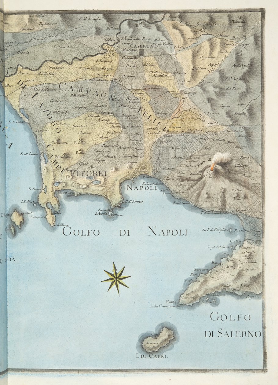
Map of the Gulf of Naples and Surrounding Area from

Map of the Gulf of Naples and Surrounding Area from 'Campi Phlegraei: Observations on the Volcanoes of the Two Sicilies', by Sir William Hamilton, Published 1776

(Map of the Gulf of Naples and surrounding area from 'Campi Phlegraei: Observations on the Volcanoes of the Two Sicilies', by Sir William Hamilton (1730-1803), published 1776 (hand coloured engraving))


Pietro Fabris

€ 119.98
Enthält 0% MwSt.
   Configure art print
1776  ·  hand coloured engraving  ·  Picture ID: 187836

Nonclassified artists  ·  Cartography

Map of the Gulf of Naples and Surrounding Area from 'Campi Phlegraei: Observations on the Volcanoes of the Two Sicilies', by Sir William Hamilton, Published 1776 by Pietro Fabris. Available as an art print on canvas, photo paper, watercolor board, uncoated paper or Japanese paper.
Private Collection / Bridgeman Images
AR/3D   View in 3D / AR zu Favoriten hinzufügen   Add to favorites    Select wall color    View painting in a room
0 Reviews

Configure art print

Picture Frame

Medium & Stretcher

Glass & Passepartout

Miscellaneous & Extras

 Save / compare configuration
Preview Icon

Summary

Gemälde
Veredelung
Keilrahmen
Museumslizenz

€ 119.98
(inkl. 20% MwSt)
   Add to cart

Bildschärfe: PERFEKT

Should you desire adjustments to brightness and color, or a custom crop of the motif, we are happy to make these changes at no additional cost to you. Please do not hesitate to contact us.

Similar artworks selected for you

1794 map of the Gulf of Naples Detail of a geography map representing Southern Italy (Campania, Calabria, Sicily, Puglia, Molise Abruzzo regions). 19th century Map of Rhode Island at the time of its occupation 1780-81 by the French Army on the orders of Jean-Baptiste de Vimeur Count of Rochambeau Roy Military Survey of Scotland Sardinia, Italy Wonder Atlas - Sicily S. Phelipe de Porto Bello Map of Gulf of Gaeta from Ipswich Bay and Cape Ann Roy Military Survey of Scotland Plano del Puerto y Rio Guayaquil en el Mar de el Sur Map of the Surroundings of Villefranche in the Count of Nice Levee in October 1748 Cartography: Comparative Heights of the Main Mountains of Italy, Synoptic Table with Reliefs, Volcanoes, Cities of Milan and Rome, Sea Level Center of Italy - by A Sicily Map of the bay and city of S. Phelipe de Portobelo Map of Mauritius, illustration from Altnaharra, Roy Military Survey of Scotland The Island of Martinique, from View of the Rock of Gibraltar and a Map of the Strait of Gibraltar Map containing the island and kingdom of Sicily, with a part of Naples, and other adjacent coasts including the Tyrrhenean Sea Map of France, Spain and North-West Africa, from the Map of the Island of Martinique, 1599 The Island of Jamaica Corsica, France Detail of Heligoland from a map of Denmark, 1730 Patagonia, from a Series of World Maps published by John Tallis und Co., New York and London, 1850s Map of the Peloponnesus A new and accurate Map of the Island of Carriacou in the West Indies
Show more similar artworks

Other art prints by Pietro Fabris

Eruption of Vesuvius, Monday 9th August 1779, Plate 3, Published as a Supplement to The Bay of Naples on the Day of the Departure of Charles III View of the Italian Coast from Near Puzzoli, Plate 26 from Specimens of Tufa found in and around Herculaneum, Plate XXXXV, from Minuet at Baia, by Pietro Fabris Stones of Crystals Called Gems of Mount Vesuvius, Plate LIIII, from Crater of Mount Vesuvius from an original drawing executed at the scene in 1756, plate 10 from View of the great eruption of Vesuvius from the mole of Naples in the night of 20 October 1767, Plate 6 from Noble dance and feast scene in Naples Early Excavations at Herculaneum, from Dance scene and popular party in Naples (detail) Scenes of Everyday Life in a Cave in Posillipo, near Naples View of Mount Vesuvius from the sea shore, from Interior of the Cone of Vesuvius Before the 1767 Eruption (plate 9 from Bay of Naples from Sea Shore Near the Maddalena Bridge, Plate 4 from
Discover more works by Pietro Fabris

Other motives from the category Cartography

Map of Seville, from Map of India, Showing the Railways Finished, in Progress and Intended, the Cotton and Coal Districts Map of Rotterdam and Gouda, from Map of Oxford Map of the City of New York [as far north as East 53rd Street], 1885 Map of Australia and Magellan Island from Map of Barbados Map of Paris and its Surroundings, from Detail showing an African ruler from a Renaissance map of Europe, Jacopo Russo (after) 1528 Map Showing the route of the Armada fleet, engraved by Augustine Ryther Map of the Battle of Friedland, Published by William Blackwood and Sons, Edinburgh and London, 1848 Map No.5 Showing the route of the Armada fleet, engraved by Augustine Ryther Feudal France at the time of the Accession of Hugues Capet in 987, map illustrated in a Histoire de France c.1880 Map of North-East China, Showing the Gulf of Pechili, the Tien-Tsin (Peiho) River, and the Approaches to Pekin Map of Australia and New Zealand
View More from "Cartography"

Excerpt from our top sellers

Tulip Fields with the Rijnsburg Windmill The Plague Comes Carnival Evening Portrait of Joan of Arc with flag and lilies on the background of Notre Dame Cathedral Beethoven Frieze Road at La Cavée, Pourville Terrace of the Café on the Place du Forum in Arles in the Evening The Quarrel of Oberon and Titania The White and the Black Salvator Mundi The Butterfly Hunter Cafe Terrace, Place du Forum, Arles, 1888 Apple Tree The Great Day of His Wrath Munich Beer Garden
Show More Artworks


What our customers think about us


Frequently Asked Questions about Meisterdrucke


Personalizing your art print at Meisterdrucke is a simple and intuitive process that allows you to design an artwork exactly to your specifications: Choose a frame, determine the image size, decide on a printing medium, and add suitable glazing or a stretcher frame. We also offer customization options such as mats, fillets, and spacers. Our customer service is available to help you design your perfect artwork.

At Meisterdrucke, you have the fascinating option to visualize the artwork you configured directly in your own space. For a tailored preview, simply upload a photo of your room and let the artwork appear on it. If you visit us via a mobile device, be it a phone or tablet, our augmented reality feature brings the image to life and seamlessly projects it into your space. An experience that uniquely combines art and technology.

Choosing the medium is often a matter of personal taste. To give you a clearer idea, we have provided some images for each medium. For a holistic experience, we also offer you a sample set of all paper variants so you can make a decision not just visually but also haptically. You can take advantage of the sample set free of charge – only the shipping costs will apply. You can order the sample set directly.

Do not worry. At Meisterdrucke, we do not proceed mechanically. We manually review each order. If there are any inconsistencies or peculiarities in the configuration, we will immediately contact you. Of course, our courteous and patient support is always at your side to assist you with the configuration. Together with you, we adjust your image by phone or email so that the final result exactly meets your expectations.


Do you have any questions?

Are you interested in an art print from our manufactory but still unsure? Do you need advice on choosing the medium or help with the order?

Our experts are happy to assist you.

+43 4257 29415
support@meisterdrucke.com
Mo-Do: 7:00 - 16:00 | Fr: 7:00 - 13:00

Do you have any questions?

Are you interested in an art print from our manufactory but still unsure? Do you need advice on choosing the medium or help with the order?

Our experts are happy to assist you.

+43 4257 29415
support@meisterdrucke.com
Mo-Do: 7:00 - 16:00 | Fr: 7:00 - 13:00


Meisterdrucke

   Kärntner Strasse 46
        9586 Finkenstein am Faaker See
        Austria
        +43 4257 29415
        support@meisterdrucke.com
Other languages

                   
Erfahrungen & Bewertungen zu Meisterdrucke
Post.at DHL Express Quehenberger Cargoboard
Kaiser Franz Joseph

Meisterdrucke
Kärntner Strasse 46
9586 Finkenstein am Faaker See · Austria
+43 4257 29415 · office@meisterdrucke.com
Post.at DHL Express Quehenberger Cargoboard


Meisterdrucke 2717 Bewertungen auf ProvenExpert.com

(c) 2025 meisterdrucke.uk