Search by artist, work title or style – e.g. Monet, Starry Night, Impressionism, Hokusai wave, nude. Describe the scene – e.g. green meadow, abstract with lots of red, dark oil painting, standing nude next to a tree.

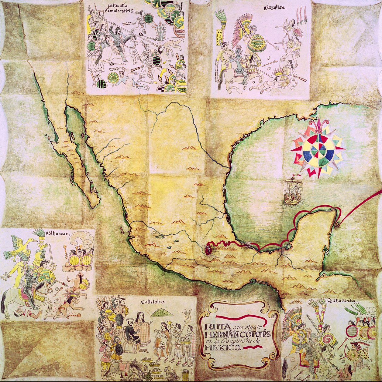
Map of the route followed by Hernando Cortes during the conquest of Mexico by Mexican School

Map of the route followed by Hernando Cortes during the conquest of Mexico

(Map of the route followed by Hernando Cortes (1485-1547) during the conquest of Mexico)


Mexican School

€ 101.12
Enthält 0% MwSt.
   Configure art print
Undated  ·  Picture ID: 36067

Cultural Circles  ·  Cartography

Map of the route followed by Hernando Cortes during the conquest of Mexico by Mexican School. Available as an art print on canvas, photo paper, watercolor board, uncoated paper or Japanese paper.
latin american · plan · carte de la conquete · conqueror · route · spanish · america · cortez · # 178 · Museo Nacional de Historia, Castillo de Chapultepec, Mexico / Bridgeman Images
AR/3D   View in 3D / AR zu Favoriten hinzufügen   Add to favorites    Select wall color    View painting in a room
0 Reviews

Configure art print

Picture Frame

Medium & Stretcher

Glass & Passepartout

Miscellaneous & Extras

 Save / compare configuration
Preview Icon

Summary

Gemälde
Veredelung
Keilrahmen
Museumslizenz

€ 101.12
(inkl. 20% MwSt)
   Add to cart

Bildschärfe: PERFEKT

Should you desire adjustments to brightness and color, or a custom crop of the motif, we are happy to make these changes at no additional cost to you. Please do not hesitate to contact us.

Similar artworks selected for you

Map of New Spain (North America) Atlas by Diego Homem of South America, showing Indians in their settlements, Spanish Expeditionary Force Camp and Men in Armour Part of Mexico and South America Detail of Roman Gaul from the Peutinger map copy Detail of Marco Polo Africa (Nubia and Egypt) Map by Stefano Bonsignori Marco Polo Ireland between Londonderry and Dublin French Map of Central and South America Pascatway River in New England, c.1660-85 Sudan Sudan The Coast of the Mediterranean from the Straits of Gibraltar to the Morea with the Adriatic Map of the Russian empire in the sixteenth century, copy of an original of 1571 Unknown Image The Continent of Africa, from an Atlas of the World in 33 Maps, Venice, 1st September 1553 Mar del Zur Africa: Egypt and Saudi Arabia, from Atlas of the World in Thirty-Three Maps Europe, from a 19th century copy of the nautical planisphere Picturesque and Historical Atlas of the United Mexican States Geography Map of the Territory of Russia from Theatrum Orbis Terrarum by Abraham Ortelius Ethiopia, the Red Sea and Saudi Arabia, from an Atlas of the World in 33 Maps, Venice, 1st September 1553 (Detail) Map of the Coast of Africa and the River Gambia Map of Florida and the Antilles, from View of the western coast of Mexico, and southern California - Map West Africa (Congo and Angola) Map Made by Stefano Bonsignori West Russia, south-east Turkey, Armenia, Azerbaijan, north Iran, Turkmenistan, Uzbekistan, west Kazakhstan Game of the Star-Spangled Banner or Emigrants to the United States Africa, from Atlas of the World in thirty-three Maps
Show more similar artworks

Other art prints by Mexican School

Representation of the Virgin of Guadalupe, Patron Saint of Mexico La Malinche Acting as Interpreter during the Presentation of Women and Gold by Montezuma to Hernando Cortes, Illustration from a Facsimile of a Mexican Indian Picture History Map of the route followed by Hernando Cortes during the conquest of Mexico White Spanish man, Black woman and mixed race son (mulatto), Painting on theme of miscegenation Portrait of Benito Juarez Mexican codex showing the genealogy of the Aztec civilisation A Half-Breed and his Lobo Indian Wife and their Child, from a series on mixed race marriages in Mexico The Templo Mayor at Tenochtitlan (from Battle of Michoacan between the Spanish and the Aztecs, illustration from a facsimile of a Mexican Indian picture history Lienzo de Tlaxcala of c.1550, 1892 Devil mask used in a Pastorela from the Guerrero region of Mexico Map of the Alamo area in San Antonio based on Santa Anna Conquest of Mexico: Battle Between Hernando Cortes and the Indians of Tabasco in 1519 Caciques Receiving Communion from a Priest in the House of Hernando Cortes, Illustration from a Facsimile of a Mexican Indian Picture History Lienzo de Tlaxcala of c.1550, 1892 Funeral of Atahualpa, August 1533 St. Diego of Alcala (1463-1588)
Discover more works by Mexican School

Other motives from the category Cartography

Map of South America Map of Fredericksburg, December 1862 Map of the Polar Region Map of Westmorland Map of Cochin, India Map of Paris at the Outbreak of the French Revolution, published by William Blackwood and Sons Map of Antwerp Map of Rovigo, from Detail of Copy of a Catalan Map of Europe and North Africa, presented to Charles V of France in 1381 Map for the Battle of Austerlitz, December 2nd, 1805 Map of Bosnia with Details of the Areas Occupied by Minority Ethnic Groups, 1910 Abraham Ortel Oretelius and his world map of 1569, illustration from Panoramic View of the Baltic Sea and the Route of the Fleet from Spithead to St. Petersburg, from Government Maps and Charts Made Under the Supervision of an Officer in the Expedition Under Sir Charle Map of the Sea of Maluku, from the Cosmographie Universelle Map of the Dominions of the Angevins, from
View More from "Cartography"

Excerpt from our top sellers

After a Gale, 1903 Allegorical Frontispiece of Rome and Its History The Open Window Joan of Arc, 1865 Lake Geneva with Mont-Blanc in Morning Red Breakfast of the Rowers Rosa Damascena, from Les Roses, 1817-24 Standing Girl Four Foxes Pine Trees Red Balloon The Magpie The Japanese Footbridge and the Water Lily Pool, Giverny Bear In Snow Woman in a Yellow Dress
Show More Artworks


What our customers think about us


Frequently Asked Questions about Meisterdrucke


Personalizing your art print at Meisterdrucke is a simple and intuitive process that allows you to design an artwork exactly to your specifications: Choose a frame, determine the image size, decide on a printing medium, and add suitable glazing or a stretcher frame. We also offer customization options such as mats, fillets, and spacers. Our customer service is available to help you design your perfect artwork.

At Meisterdrucke, you have the fascinating option to visualize the artwork you configured directly in your own space. For a tailored preview, simply upload a photo of your room and let the artwork appear on it. If you visit us via a mobile device, be it a phone or tablet, our augmented reality feature brings the image to life and seamlessly projects it into your space. An experience that uniquely combines art and technology.

Choosing the medium is often a matter of personal taste. To give you a clearer idea, we have provided some images for each medium. For a holistic experience, we also offer you a sample set of all paper variants so you can make a decision not just visually but also haptically. You can take advantage of the sample set free of charge – only the shipping costs will apply. You can order the sample set directly.

Do not worry. At Meisterdrucke, we do not proceed mechanically. We manually review each order. If there are any inconsistencies or peculiarities in the configuration, we will immediately contact you. Of course, our courteous and patient support is always at your side to assist you with the configuration. Together with you, we adjust your image by phone or email so that the final result exactly meets your expectations.


Do you have any questions?

Are you interested in an art print from our manufactory but still unsure? Do you need advice on choosing the medium or help with the order?

Our experts are happy to assist you.

+43 4257 29415
support@meisterdrucke.com
Mo-Do: 7:00 - 16:00 | Fr: 7:00 - 13:00

Do you have any questions?

Are you interested in an art print from our manufactory but still unsure? Do you need advice on choosing the medium or help with the order?

Our experts are happy to assist you.

+43 4257 29415
support@meisterdrucke.com
Mo-Do: 7:00 - 16:00 | Fr: 7:00 - 13:00


Meisterdrucke

   Kärntner Strasse 46
        9586 Finkenstein am Faaker See
        Austria
        +43 4257 29415
        support@meisterdrucke.com
Other languages

                   
Erfahrungen & Bewertungen zu Meisterdrucke
Post.at DHL Express Quehenberger Cargoboard
Kaiser Franz Joseph

Meisterdrucke
Kärntner Strasse 46
9586 Finkenstein am Faaker See · Austria
+43 4257 29415 · office@meisterdrucke.com
Post.at DHL Express Quehenberger Cargoboard


Meisterdrucke 2734 Bewertungen auf ProvenExpert.com

(c) 2025 meisterdrucke.uk