support@meisterdrucke.com  ·  0043 4257 29415

Deutsch English Italiano Español Français Nederlands Português Svenska Polski Dansk
Search by artist, work title or style – e.g. Monet, Starry Night, Impressionism, Hokusai wave, nude. Describe the scene – e.g. green meadow, abstract with lots of red, dark oil painting, standing nude next to a tree.

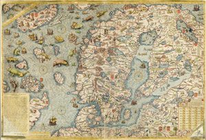
Map of Northern Europe, from 'Civitates Orbis Terrarum' by Georg Braun (1541-1622) and Frans Hogenberg (1535-90), c. 1572-1617 by Joris Hoefnagel

Map of Northern Europe, from 'Civitates Orbis Terrarum' by Georg Braun (1541-1622) and Frans Hogenberg (1535-90), c. 1572-1617

(Map of Northern Europe, from 'Civitates Orbis Terrarum' by Georg Braun (1541-1622) and Frans Hogenberg (1535-90) c.1572-1617 )


Joris Hoefnagel

€ 115.18
Tax-free
   Configure art print
Undated  ·  coloured engraving  ·  Image ID: 265610

Flemish painting  ·  Cartography

Map of Northern Europe, from 'Civitates Orbis Terrarum' by Georg Braun (1541-1622) and Frans Hogenberg (1535-90), c. 1572-1617 by Joris Hoefnagel. Available as an art print on canvas, photo paper, watercolor board, natural paper, or Japanese paper.
cities of the world · netherlands · finland · sweden · denmark · crest · coat of arms · Private Collection / Bridgeman Images
AR/3D   View in 3D / AR zu Favoriten hinzufügen   Add to favorites    Change wall color    View picture in a room
0 Reviews

Configure art print

Picture Frame

Medium & Stretcher

Glass & Passepartout

Miscellaneous & Extras

 Save / compare configuration
Preview Icon

Summary

Gemälde
Veredelung
Keilrahmen
Museumslizenz

€ 115.18
(inkl. 20% MwSt)
   Add to cart

Bildschärfe: PERFEKT

If you'd like us to adjust the brightness, colors, or crop the image, we're happy to do this for you at no extra cost. Just get in touch!

Similar artworks selected for you

Denmark - in Jutland, Denmark Map of Zeeland, c. 1560 Scandinavia, detail from the Carta Marina by Olaus Magnus, 1572 1593 Map of Northern Europe DeBry Map of Caribbean & Florida 1594 Map of Northern Europe Northern Europe, from Atlas of the World in thirty-three Maps Map of Scandinavia Central Ireland, Dublin to Sligo Northern Europe, from an Atlas of the World in 33 Maps, Venice, 1st September 1553 A General Card and Description of the Sea Coasts of Europe, and Navigation Contained in This Book Map of the East Indies, published 1635 in Amsterdam A Map of Iceland circa 1588 Fol. 30v Map of the Sea of Maluku, from the Carta Marina, Original A Map of Great Britain Isle of Rugen, Germany (engraving) New and Accurate Map of the Lands and Kingdoms of California, New Spain, Mexico, and Peru Scandinavia, detail from the Carta Marina by Olaus Magnus, 1572 Map of the Caribbean islands and the American state of Florida Map of the Sea (Carta marina) by Olaus Magnus (1490-1557) Slide of Consultation and Public Access Information Investigated from a Book and/or Review Copy Kept in the Bibliographic and Cartographic Collections Geography map of Scandinavia and Northern Europe from Map of Denmark, from Theatrum Orbis Terrarum Map of the Kingdom of Denmark Map of Northern Europe, from Theatrum Orbis Terrarum by Abraham Ortelius A Map of Iceland Around 1588 Chart of the Mediterranean, Showing Italy and the North African Coast
Show more similar artworks

Similar artworks selected for you

Denmark - in Jutland, Denmark Map of Zeeland, c. 1560 Scandinavia, detail from the Carta Marina by Olaus Magnus, 1572 1593 Map of Northern Europe DeBry Map of Caribbean & Florida 1594 Map of Northern Europe Northern Europe, from Atlas of the World in thirty-three Maps Map of Scandinavia Central Ireland, Dublin to Sligo Northern Europe, from an Atlas of the World in 33 Maps, Venice, 1st September 1553 A General Card and Description of the Sea Coasts of Europe, and Navigation Contained in This Book Map of the East Indies, published 1635 in Amsterdam A Map of Iceland circa 1588 Fol. 30v Map of the Sea of Maluku, from the Carta Marina, Original A Map of Great Britain Isle of Rugen, Germany (engraving) New and Accurate Map of the Lands and Kingdoms of California, New Spain, Mexico, and Peru Scandinavia, detail from the Carta Marina by Olaus Magnus, 1572 Map of the Caribbean islands and the American state of Florida Map of the Sea (Carta marina) by Olaus Magnus (1490-1557) Slide of Consultation and Public Access Information Investigated from a Book and/or Review Copy Kept in the Bibliographic and Cartographic Collections Geography map of Scandinavia and Northern Europe from Map of Denmark, from Theatrum Orbis Terrarum Map of the Kingdom of Denmark Map of Northern Europe, from Theatrum Orbis Terrarum by Abraham Ortelius A Map of Iceland Around 1588 Chart of the Mediterranean, Showing Italy and the North African Coast
Show more similar artworks

More art prints by Joris Hoefnagel

Map of London, from Snail, c.1575-80 Plate 17: White Heron(?) and Black Stork Killing a Snake with a Dragon Plate 17: Brimstone and Meadow Brown(?) Butterflies, a Dragonfly, and Two Small Insects Plate 65: Blackbird, Starling (?), and Other Birds Plate 54: Hairy Dragonfly and Two Darters Scarab beetle, c.1575-80 Map of Leipzig, from „Civitates Orbis Terrarum“ by Georg Braun (1541-1622) and Frans Hogenberg (1535-90), c. 1572 Dragonfly, c. 1575-80 Map of Rome, from Map of Lisbon, from Plate 56: Two Heads of Cabbage Plate 23: Hawk Moth, Butterflies, and Other Insects around a Snowberry Sprig Map of Cambridge, from Map of Regensburg, from
Show more works by Joris Hoefnagel

More art prints by Joris Hoefnagel

Map of London, from Snail, c.1575-80 Plate 17: White Heron(?) and Black Stork Killing a Snake with a Dragon Plate 17: Brimstone and Meadow Brown(?) Butterflies, a Dragonfly, and Two Small Insects Plate 65: Blackbird, Starling (?), and Other Birds Plate 54: Hairy Dragonfly and Two Darters Scarab beetle, c.1575-80 Map of Leipzig, from „Civitates Orbis Terrarum“ by Georg Braun (1541-1622) and Frans Hogenberg (1535-90), c. 1572 Dragonfly, c. 1575-80 Map of Rome, from Map of Lisbon, from Plate 56: Two Heads of Cabbage Plate 23: Hawk Moth, Butterflies, and Other Insects around a Snowberry Sprig Map of Cambridge, from Map of Regensburg, from
Show more works by Joris Hoefnagel

More motifs from the category Cartography

Map of Tenochtitlan and the Gulf of Mexico, from Praeclara Ferdinadi Cortesii de Nova maris Oceani Hyspania Narratio by Hernando Cortés (1485-1547), 1524 Map of Lilliput and Blefuscu, from the first edition of Van Diemen’s Island or Tasmania, from a Series of World Maps published by John Tallis and Co., London and New York, 1850s A new and correct map of the trading part of the West Indies, 1741 Map of Map of Zamość, from Map of the Eastern Part of the Roman Empire, from Map showing the localities of the Indian tribes of the US in 1833, illustration from General map including Arabia, Japan, the Korean peninsula and the greater part of the Indonesian archipelago, 1631 Map of Britain, 1631 Detail of the Right Bank, from the map of Paris c. 1540, known as the Plan de la Tapisserie, made as a tapestry c. 1570, 1818 colour engraving Map of the City and Portuguese Port of Goa, India, 1595 A map showing the journey of the Israelites out of Egypt and into Canaan, facsimile of an image from the Geneva Bible of 1560 Panoramic view of the Baltic Sea and the Route of the Fleet from Spithead to St. Petersburg, from government maps and charts made under the supervision of an officer in the expedition under Sir Charles Map of Namur, from ’Civitates Orbis Terrarum’ by Georg Braun (1541-1622) and Frans Hogenberg (1535-90), c. 1572-1617
View More from "Cartography"

More motifs from the category Cartography

Map of Tenochtitlan and the Gulf of Mexico, from Praeclara Ferdinadi Cortesii de Nova maris Oceani Hyspania Narratio by Hernando Cortés (1485-1547), 1524 Map of Lilliput and Blefuscu, from the first edition of Van Diemen’s Island or Tasmania, from a Series of World Maps published by John Tallis and Co., London and New York, 1850s A new and correct map of the trading part of the West Indies, 1741 Map of Map of Zamość, from Map of the Eastern Part of the Roman Empire, from Map showing the localities of the Indian tribes of the US in 1833, illustration from General map including Arabia, Japan, the Korean peninsula and the greater part of the Indonesian archipelago, 1631 Map of Britain, 1631 Detail of the Right Bank, from the map of Paris c. 1540, known as the Plan de la Tapisserie, made as a tapestry c. 1570, 1818 colour engraving Map of the City and Portuguese Port of Goa, India, 1595 A map showing the journey of the Israelites out of Egypt and into Canaan, facsimile of an image from the Geneva Bible of 1560 Panoramic view of the Baltic Sea and the Route of the Fleet from Spithead to St. Petersburg, from government maps and charts made under the supervision of an officer in the expedition under Sir Charles Map of Namur, from ’Civitates Orbis Terrarum’ by Georg Braun (1541-1622) and Frans Hogenberg (1535-90), c. 1572-1617
View More from "Cartography"

A selection of our top sellers

Trail in the woods, c. 1874-77 Alpine Hut in Rainy Weather, 1850 Reflection in the Surface of the Water, Misaka, Kai Province from the series Thirty-Six Views of Mt Fuji, 1830-1833 Family Picnic Melancholia, 1514 The Quiet Room Landscape on Saint-Martin Island, 1881 Mountain farmers mowing Orchard with roses Summer Night by the Beach Girl with a Pearl Earring, c. 1665-6 Luncheon of the Boating Party The School Walk, 1872 Wintry Full Moon Landscape Red Vineyard at Arles
Show more artworks

A selection of our top sellers

Trail in the woods, c. 1874-77 Alpine Hut in Rainy Weather, 1850 Reflection in the Surface of the Water, Misaka, Kai Province from the series Thirty-Six Views of Mt Fuji, 1830-1833 Family Picnic Melancholia, 1514 The Quiet Room Landscape on Saint-Martin Island, 1881 Mountain farmers mowing Orchard with roses Summer Night by the Beach Girl with a Pearl Earring, c. 1665-6 Luncheon of the Boating Party The School Walk, 1872 Wintry Full Moon Landscape Red Vineyard at Arles
Show more artworks


What our customers think about us


Frequently Asked Questions about Meisterdrucke


Personalizing your art print at Meisterdrucke is simple and intuitive: Choose a frame, set the image size, pick a printing medium, and add suitable glazing or a stretcher frame. We also offer additional customization options like mats, fillets, and spacers. If you have any questions, our customer service team is ready to help you create your perfect artwork.

At Meisterdrucke, you can visualize your configured artwork directly in your own room. Simply upload a photo of your space and see how the artwork looks in it. If you're visiting us on a mobile device — phone or tablet — our augmented reality feature brings the picture to life and projects it right into your room. A unique experience that combines art and technology.

Choosing the right medium is often a matter of personal taste. To give you a better idea, we've provided some images for each medium. We also offer a sample set of all paper variants, so you can decide not just visually but by touch as well. You can order the sample set free of charge — only shipping costs apply.

Don't worry! At Meisterdrucke, we don't just process orders mechanically. Every order is manually reviewed by our team. If we spot any inconsistencies or issues with your configuration, we'll get in touch with you right away. And of course, our friendly and patient support team is always here to help you with your configuration. We'll work with you by phone or email to adjust your image so the final result is exactly what you had in mind.


Still have questions?

Are you interested in an art print from our manufactory but still unsure? Do you need advice on choosing the medium or help with the order?

Our experts are happy to assist you.

+43 4257 29415
support@meisterdrucke.com
Mo-Do: 7:00 - 16:00 | Fr: 7:00 - 13:00

Still have questions?

Are you interested in an art print from our manufactory but still unsure? Do you need advice on choosing the medium or help with the order?

Our experts are happy to assist you.

+43 4257 29415
support@meisterdrucke.com
Mo-Do: 7:00 - 16:00 | Fr: 7:00 - 13:00


Meisterdrucke

   Kärntner Strasse 46
        9586 Finkenstein am Faaker See
        Austria
        +43 4257 29415
        support@meisterdrucke.com
Other languages

                   
Erfahrungen & Bewertungen zu Meisterdrucke
Post.at DHL Express Quehenberger Cargoboard
Kaiser Franz Joseph

Meisterdrucke
Kärntner Strasse 46
9586 Finkenstein am Faaker See · Austria
+43 4257 29415 · support@meisterdrucke.com
Post.at DHL Express Quehenberger Cargoboard


(c) 2026 meisterdrucke.uk