support@meisterdrucke.com  ·  0043 4257 29415

Deutsch English Italiano Español Français Nederlands Português Svenska Polski Dansk
Search by artist, work title or style – e.g. Monet, Starry Night, Impressionism, Hokusai wave, nude. Describe the scene – e.g. green meadow, abstract with lots of red, dark oil painting, standing nude next to a tree.

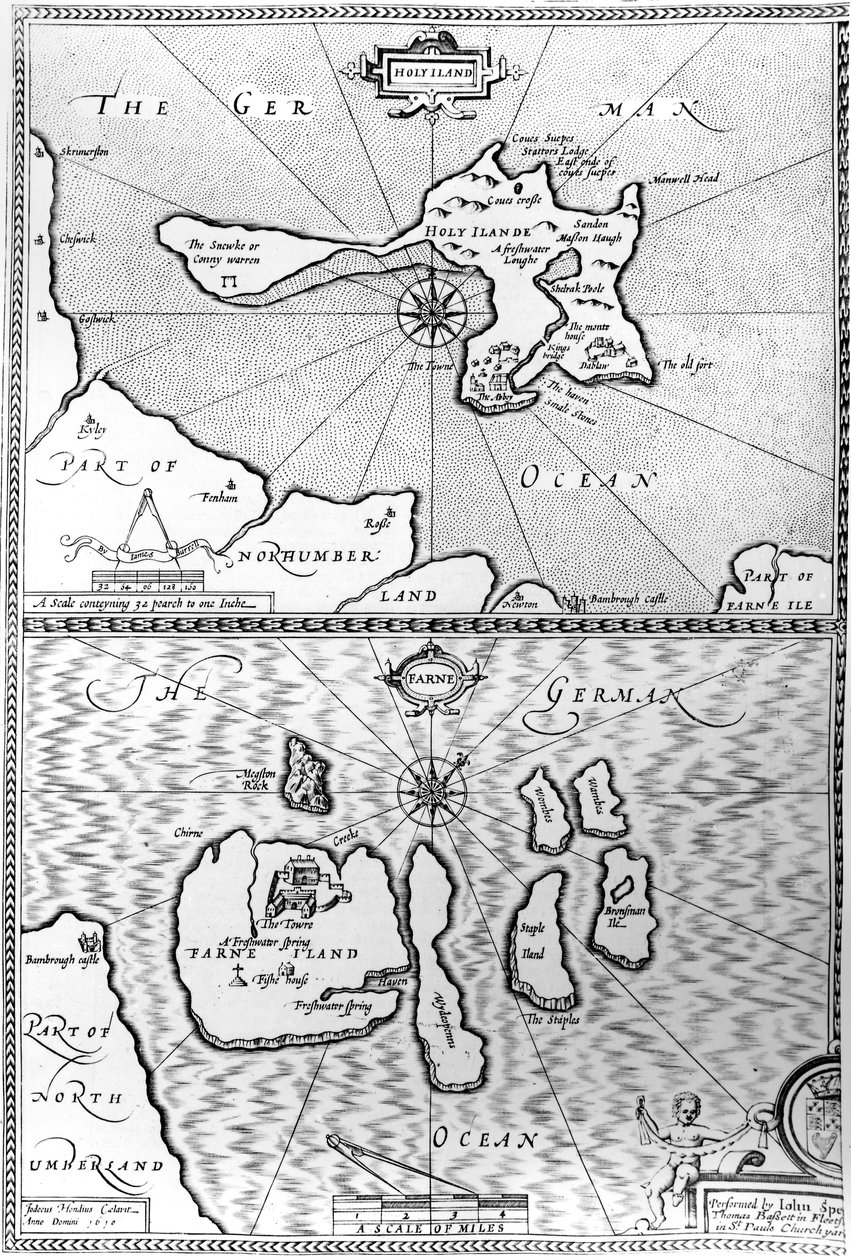
Maps of Holy Island and Farne Island, Northumberland, from 'The Theatre of the Empire of Great Britaine' by John Speed, 1676 by John Speed

Maps of Holy Island and Farne Island, Northumberland, from 'The Theatre of the Empire of Great Britaine' by John Speed, 1676

(Maps of Holy Island and Farne Island, Northumberland, from 'The Theatre of the Empire of Great Britaine' by John Speed, 1676 )


John Speed

€ 136.07
Tax-free
   Configure art print
1676  ·  engraving  ·  Image ID: 77185

Nonclassified artists  ·  Cartography

Maps of Holy Island and Farne Island, Northumberland, from 'The Theatre of the Empire of Great Britaine' by John Speed, 1676 by John Speed. Available as an art print on canvas, photo paper, watercolor board, natural paper, or Japanese paper.
Private Collection / Bridgeman Images
AR/3D   View in 3D / AR zu Favoriten hinzufügen   Add to favorites    Change wall color    View picture in a room
0 Reviews

Configure art print

Picture Frame

Medium & Stretcher

Glass & Passepartout

Miscellaneous & Extras

 Save / compare configuration
Preview Icon

Summary

Gemälde
Veredelung
Keilrahmen
Museumslizenz

€ 136.07
(inkl. 20% MwSt)
   Add to cart

Bildschärfe: PERFEKT

If you'd like us to adjust the brightness, colors, or crop the image, we're happy to do this for you at no extra cost. Just get in touch!

Similar artworks selected for you

Plan Showing the Strait of Constantinople (now the Strait of Bosphorus) - in Map including Massachusetts Bay Map of Atlantis, from South Part of New England as it is Planted this Year 1634 Map of Lake Ontario with the English and French fleets The Thames Estuary from The Sea-Mirrour atlas by Willem Janszoon Blaeu, published in Amsterdam in 1633 Connecticut Map No. 6 showing the route of the Armada fleet, engraved by Augustine Ryther, 1588 Map of Atlantis, from Map of countries first discovered by Christopher Columbus (1451-1506), 1500 The Islands of Samoa and Maouna, from the itinerary of La Pérouse Legendary Island of Atlantis Map of the Corsica from the Map of Atlantis, from Bristol Channel Turtle Island and Santo Domingo from a 17th century map by Pierre Vandier The South Pole, detail from the ’Mappamonde à Projection Cordiforme’, 1531 Island of Cuba, Florida and Gulf of Mexico, engraving from Map of an Island in the Treasure (Pirates?) Map of the Island of Zante, a Venetian Stronghold Against the Turks Map of Laputa, Balnibari, Luggnagg, Glubbdubdrib and Japan, illustration from the first edition of Map showing location of the Houyhnhnms Land from first edition of Gulliver Map No. 3 Showing the Route of the Armada Fleet, engraved by Augustine Ryther, 1588 Map from Easter Island, from Travel Atlas by James Cook The Arrival of Vice-Admiral Wybrandt Van Warwijck Map No. 9 showing the route of the Armada fleet, engraved by Augustine Ryther, 1588 Map of the Isthmus of Darien and the Gulf of Panama in
Show more similar artworks

Similar artworks selected for you

Plan Showing the Strait of Constantinople (now the Strait of Bosphorus) - in Map including Massachusetts Bay Map of Atlantis, from South Part of New England as it is Planted this Year 1634 Map of Lake Ontario with the English and French fleets The Thames Estuary from The Sea-Mirrour atlas by Willem Janszoon Blaeu, published in Amsterdam in 1633 Connecticut Map No. 6 showing the route of the Armada fleet, engraved by Augustine Ryther, 1588 Map of Atlantis, from Map of countries first discovered by Christopher Columbus (1451-1506), 1500 The Islands of Samoa and Maouna, from the itinerary of La Pérouse Legendary Island of Atlantis Map of the Corsica from the Map of Atlantis, from Bristol Channel Turtle Island and Santo Domingo from a 17th century map by Pierre Vandier The South Pole, detail from the ’Mappamonde à Projection Cordiforme’, 1531 Island of Cuba, Florida and Gulf of Mexico, engraving from Map of an Island in the Treasure (Pirates?) Map of the Island of Zante, a Venetian Stronghold Against the Turks Map of Laputa, Balnibari, Luggnagg, Glubbdubdrib and Japan, illustration from the first edition of Map showing location of the Houyhnhnms Land from first edition of Gulliver Map No. 3 Showing the Route of the Armada Fleet, engraved by Augustine Ryther, 1588 Map from Easter Island, from Travel Atlas by James Cook The Arrival of Vice-Admiral Wybrandt Van Warwijck Map No. 9 showing the route of the Armada fleet, engraved by Augustine Ryther, 1588 Map of the Isthmus of Darien and the Gulf of Panama in
Show more similar artworks

More art prints by John Speed

A new and accurate map of the world, 1676 The Turkish Empire, 1626 Maps of Holy Island and Farne Island, Northumberland, from Map of Tartary by John Speed The Bishoprick and City of Durham, engraved by Jodocus Hondius (1563-1612) from John Speed’s “Theatre of the Empire of Great Britain”, published by John Sudbury and George Humble, 1611-12 (hand-coloured) Britain as It Was Divided in the Time of the English Saxons, 1616 A New Map of the Roman Empire, from "A Prospect of the Most Famous Parts of the World", published by Bassett and Chiswell, 1676 The County of Warwick, the Shire Town and the City of Coventry, engraved by Jodocus Hondius (1563-1612), from John Speed’s ’Theatre of the Empire of Great Britain’, published by John Sudbury and George Humb The Kingdome of Scotland, engraved by Jodocus Hondius (1563-1612) from ‘Theatre of the Empire of Great Britain’, published by John Sudbury and George Humble, 1611-12 Worcestershire, engraved by Jodocus Hondius (1563-1612) from John Speed’s ’Theatre of the Empire of Great Britain’, published by John Sudbury and George Humble 1611-12 Middlesex described with the most famous cities of London and Westminster, from Speed Lancashire in 1610, from John Speed’s ’Theatre of the Empire of Great Britaine’, first edition, published 1611-12 Hull, detail from the map of the North and East Ridings of Yorkshire, engraved by Jodocus Hondius (1563-1612) from John Speed’s ’Theatre of the Empire of Great Britain’, published by John Sudbury and Georg Wales, engraved by Jodocus Hondius (1563-1612) from John Speed’s ’Theatre of the Empire of Great Britain’, published by John Sudbury and George Humble, 1611-12 Map of Cornwall from the
Show more works by John Speed

More art prints by John Speed

A new and accurate map of the world, 1676 The Turkish Empire, 1626 Maps of Holy Island and Farne Island, Northumberland, from Map of Tartary by John Speed The Bishoprick and City of Durham, engraved by Jodocus Hondius (1563-1612) from John Speed’s “Theatre of the Empire of Great Britain”, published by John Sudbury and George Humble, 1611-12 (hand-coloured) Britain as It Was Divided in the Time of the English Saxons, 1616 A New Map of the Roman Empire, from "A Prospect of the Most Famous Parts of the World", published by Bassett and Chiswell, 1676 The County of Warwick, the Shire Town and the City of Coventry, engraved by Jodocus Hondius (1563-1612), from John Speed’s ’Theatre of the Empire of Great Britain’, published by John Sudbury and George Humb The Kingdome of Scotland, engraved by Jodocus Hondius (1563-1612) from ‘Theatre of the Empire of Great Britain’, published by John Sudbury and George Humble, 1611-12 Worcestershire, engraved by Jodocus Hondius (1563-1612) from John Speed’s ’Theatre of the Empire of Great Britain’, published by John Sudbury and George Humble 1611-12 Middlesex described with the most famous cities of London and Westminster, from Speed Lancashire in 1610, from John Speed’s ’Theatre of the Empire of Great Britaine’, first edition, published 1611-12 Hull, detail from the map of the North and East Ridings of Yorkshire, engraved by Jodocus Hondius (1563-1612) from John Speed’s ’Theatre of the Empire of Great Britain’, published by John Sudbury and Georg Wales, engraved by Jodocus Hondius (1563-1612) from John Speed’s ’Theatre of the Empire of Great Britain’, published by John Sudbury and George Humble, 1611-12 Map of Cornwall from the
Show more works by John Speed

More motifs from the category Cartography

Map of Seville, from Map of Cutch and Kathiawar, published under the direction of Colonel G.C. de Pree, S.C., Surveyor General of India, 1885 Map of Paris in 1789, 1887 Septentrionalium terrarum descriptio, map of the Arctic, 1595 Map of Trento, from Les Villes de Venetie, 1704, published by Pierre Mortier in Amsterdam Map No. 1 showing the route of the Armada fleet, engraved by Augustine Ryther, 1588 Map of India, published under the direction of Colonel H.R. Thuillier, R.E., Surveyor General of India, 1877 Map of Canada, published Paris, 1703 World map tracing Magellan Map of China Map of Sussex Map of Africa, plate 18 from an Atlas of the World, 1486 Map of Paris showing Île de la Cité, from L’Atlas de Paris by Jean de la Caille, 1714 Atlas 131 H f.1, Map of Bas-Poitou, Pays d A Map of Tyburn, 1746 (detail of 438496)
View More from "Cartography"

More motifs from the category Cartography

Map of Seville, from Map of Cutch and Kathiawar, published under the direction of Colonel G.C. de Pree, S.C., Surveyor General of India, 1885 Map of Paris in 1789, 1887 Septentrionalium terrarum descriptio, map of the Arctic, 1595 Map of Trento, from Les Villes de Venetie, 1704, published by Pierre Mortier in Amsterdam Map No. 1 showing the route of the Armada fleet, engraved by Augustine Ryther, 1588 Map of India, published under the direction of Colonel H.R. Thuillier, R.E., Surveyor General of India, 1877 Map of Canada, published Paris, 1703 World map tracing Magellan Map of China Map of Sussex Map of Africa, plate 18 from an Atlas of the World, 1486 Map of Paris showing Île de la Cité, from L’Atlas de Paris by Jean de la Caille, 1714 Atlas 131 H f.1, Map of Bas-Poitou, Pays d A Map of Tyburn, 1746 (detail of 438496)
View More from "Cartography"

A selection of our top sellers

Avenue in Overveen Reflection in the Surface of the Water, Misaka, Kai Province from the series Thirty-Six Views of Mt Fuji, 1830-1833 The Stages of Life Dance from the series The Arts, 1898 Wintry Full Moon Landscape View of L Spring, maiden gathering flowers, from the villa of Varano in Stabiae, c. 15 BC-60 AD The Waterlily Pond with the Japanese Bridge Wyk on Föhr, advertising poster for the Wyk Steam Shipping Company, 1897 Portrait of a Woman, 1909 The Gull Starry Night, c. 1850-65 The Tower of Babel (Rotterdam) The Hay Wain The Attic Room
Show more artworks

A selection of our top sellers

Avenue in Overveen Reflection in the Surface of the Water, Misaka, Kai Province from the series Thirty-Six Views of Mt Fuji, 1830-1833 The Stages of Life Dance from the series The Arts, 1898 Wintry Full Moon Landscape View of L Spring, maiden gathering flowers, from the villa of Varano in Stabiae, c. 15 BC-60 AD The Waterlily Pond with the Japanese Bridge Wyk on Föhr, advertising poster for the Wyk Steam Shipping Company, 1897 Portrait of a Woman, 1909 The Gull Starry Night, c. 1850-65 The Tower of Babel (Rotterdam) The Hay Wain The Attic Room
Show more artworks


What our customers think about us


Frequently Asked Questions about Meisterdrucke


Personalizing your art print at Meisterdrucke is simple and intuitive: Choose a frame, set the image size, pick a printing medium, and add suitable glazing or a stretcher frame. We also offer additional customization options like mats, fillets, and spacers. If you have any questions, our customer service team is ready to help you create your perfect artwork.

At Meisterdrucke, you can visualize your configured artwork directly in your own room. Simply upload a photo of your space and see how the artwork looks in it. If you're visiting us on a mobile device — phone or tablet — our augmented reality feature brings the picture to life and projects it right into your room. A unique experience that combines art and technology.

Choosing the right medium is often a matter of personal taste. To give you a better idea, we've provided some images for each medium. We also offer a sample set of all paper variants, so you can decide not just visually but by touch as well. You can order the sample set free of charge — only shipping costs apply.

Don't worry! At Meisterdrucke, we don't just process orders mechanically. Every order is manually reviewed by our team. If we spot any inconsistencies or issues with your configuration, we'll get in touch with you right away. And of course, our friendly and patient support team is always here to help you with your configuration. We'll work with you by phone or email to adjust your image so the final result is exactly what you had in mind.


Still have questions?

Are you interested in an art print from our manufactory but still unsure? Do you need advice on choosing the medium or help with the order?

Our experts are happy to assist you.

+43 4257 29415
support@meisterdrucke.com
Mo-Do: 7:00 - 16:00 | Fr: 7:00 - 13:00

Still have questions?

Are you interested in an art print from our manufactory but still unsure? Do you need advice on choosing the medium or help with the order?

Our experts are happy to assist you.

+43 4257 29415
support@meisterdrucke.com
Mo-Do: 7:00 - 16:00 | Fr: 7:00 - 13:00


Meisterdrucke

   Kärntner Strasse 46
        9586 Finkenstein am Faaker See
        Austria
        +43 4257 29415
        support@meisterdrucke.com
Other languages

                   
Erfahrungen & Bewertungen zu Meisterdrucke
Post.at DHL Express Quehenberger Cargoboard
Kaiser Franz Joseph

Meisterdrucke
Kärntner Strasse 46
9586 Finkenstein am Faaker See · Austria
+43 4257 29415 · support@meisterdrucke.com
Post.at DHL Express Quehenberger Cargoboard


(c) 2026 meisterdrucke.uk