support@meisterdrucke.com  ·  0043 4257 29415

Deutsch English Italiano Español Français Nederlands Português Svenska Polski Dansk
Search by artist, work title or style – e.g. Monet, Starry Night, Impressionism, Hokusai wave, nude. Describe the scene – e.g. green meadow, abstract with lots of red, dark oil painting, standing nude next to a tree.

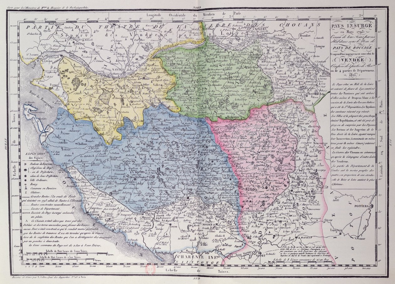
Map of the Vendée depicting the area of the Vendée Revolt (1793-96) in March 1793, c. 1815 by F. Colliu

Map of the Vendée depicting the area of the Vendée Revolt (1793-96) in March 1793, c. 1815

(Map of the Vendee depicting the area of the Vendean Revolt (1793-96) in March 1793,c.1815 (colour engraving))


F. Colliu

€ 128.2
Tax-free
   Configure art print
1815  ·  colour engraving  ·  Image ID: 362520

Nonclassified artists  ·  Cartography

Map of the Vendée depicting the area of the Vendée Revolt (1793-96) in March 1793, c. 1815 by F. Colliu. Available as an art print on canvas, photo paper, watercolor board, natural paper, or Japanese paper.
royalist · insurgency · boccage · Bibliotheque Nationale de Cartes et Plans, Paris, France / Bridgeman Images
AR/3D   View in 3D / AR zu Favoriten hinzufügen   Add to favorites    Change wall color    View picture in a room
0 Reviews

Configure art print

Picture Frame

Medium & Stretcher

Glass & Passepartout

Miscellaneous & Extras

 Save / compare configuration
Preview Icon

Summary

Gemälde
Veredelung
Keilrahmen
Museumslizenz

€ 128.2
(inkl. 20% MwSt)
   Add to cart

Bildschärfe: PERFEKT

If you'd like us to adjust the brightness, colors, or crop the image, we're happy to do this for you at no extra cost. Just get in touch!

Similar artworks selected for you

Swabian Circle Including All Subdivided States Trans-Island Territory by Barthold Wicheringe Map of Persia South-West Turkmenistan, Iran, West Afghanistan, West Pakistan A New Map of Turkey in Asia Map of the Flanders Campaign Between French Army and Austrian Army Map of the Kingdom of Hungary and the States which are United to its Crown, published by Jan Barend Elwe, Amsterdam, 1742 General Government of the Duchy of Burgundy, County of Bresse, Lands of Bugey, Valromey, and Gex, etc. Map of the Kingdom of Hungary (etching) Gaul divided into Roman provinces - Plate extracted from Land Map of the Electorate of Brandenburg with Royal Prussian Privilege Map of Silesia, from an Atlas Map of the Byzantine Empire during the occupation of Bulgarians and Italy during the reign of Otto I, Otto II and Otto III Map of Persia Turkey in Asia Clivia Ducatus Cliuia Ducatus et Rauestein Dominium Map of Germany, Germania Antiqua, from The Kingdom of Bohemia, the Duchy of Silesia, the Margraviates of Moravia and Lusatia Map of Independent Tartary, comprising the land of the Kalmyks, that of the Uzbeks, and Turkestan Map of France, Gallia Antiqua, from Large part of Croatia except the north, Bosnia and Herzegovina, Serbia and Montenegro, large part of Bulgaria except the south, southern Ukraine, Moldova, Romania, southern Slovakia, Hungary Alsatia, Germany (engraving) Geographical Map of the Theatre of War, Showing the Kingdom of Hungary in the Main, 1771 Map of the Swiss Federation (etching) Electorate of Hanover Hungarian War Theatre Map of Armenia, Colchis, Iberia and Albania, from Switzerland
Show more similar artworks

More motifs from the category Cartography

Ms. 988 Vol. 3, fol. 61 Map of the United States, 1816 Map of India, published under the direction of Colonel H.R. Thuillier, R.E., Surveyor General of India, 1877 Patagonia, from a Series of World Maps published by John Tallis and Co., New York and London, 1850s Map of the West Indies, Florida and South America Nova Scotia and Newfoundland, from a series of world maps published by John Tallis and Co., New York and London, in the 1850s Fol. 10v Map of Scandinavia and Northern Russia, from Maps of Holy Island and Farne Island, Northumberland, from Map of Warsaw, from ’Civitates Orbis Terrarum’ by Georg Braun (1541-1622) and Frans Hogenberg (1535-90), c. 1572-1617 A Map of Tyburn, 1746 (detail of 438496) German Map Showing the Extent of Surface Area and Population of the Principal Countries of Europe, c. 1785 Celestial Map of the Planets City Map of Jerusalem in the 1890s, from Map of Palestine, from Theatrum Orbis Terrarum, 1570 Map of British Southern India, 1872
View More from "Cartography"

A selection of our top sellers

Pergola on Capri with a View of Vesuvius What Freedom! 1903 Poster for the 14th Exhibition of Vienna Secession, 1902 P. Modersohn-Becker, Girl Salvator Mundi, c. 1500 Farm Garden Cartoon by Daumier: Series “Les Gens de justice”, published in “Charivari” of 15/08/1845. A lawyer pleading in court while sleeping. A stroll on the beach Landscape from Saint-Rémy Woman in White Stockings, c. 1861 Self-Portrait with Physalis The Japanese Bridge Solitary Tree The School of Athens, from the Stanza della Segnatura, 1509-10 The Great Wave off the Coast of Kanagawa, c. 1829-c. 1831
Show more artworks


What our customers think about us


Frequently Asked Questions about Meisterdrucke


Personalizing your art print at Meisterdrucke is simple and intuitive: Choose a frame, set the image size, pick a printing medium, and add suitable glazing or a stretcher frame. We also offer additional customization options like mats, fillets, and spacers. If you have any questions, our customer service team is ready to help you create your perfect artwork.

At Meisterdrucke, you can visualize your configured artwork directly in your own room. Simply upload a photo of your space and see how the artwork looks in it. If you're visiting us on a mobile device — phone or tablet — our augmented reality feature brings the picture to life and projects it right into your room. A unique experience that combines art and technology.

Choosing the right medium is often a matter of personal taste. To give you a better idea, we've provided some images for each medium. We also offer a sample set of all paper variants, so you can decide not just visually but by touch as well. You can order the sample set free of charge — only shipping costs apply.

Don't worry! At Meisterdrucke, we don't just process orders mechanically. Every order is manually reviewed by our team. If we spot any inconsistencies or issues with your configuration, we'll get in touch with you right away. And of course, our friendly and patient support team is always here to help you with your configuration. We'll work with you by phone or email to adjust your image so the final result is exactly what you had in mind.


Still have questions?

Are you interested in an art print from our manufactory but still unsure? Do you need advice on choosing the medium or help with the order?

Our experts are happy to assist you.

+43 4257 29415
support@meisterdrucke.com
Mo-Do: 7:00 - 16:00 | Fr: 7:00 - 13:00

Still have questions?

Are you interested in an art print from our manufactory but still unsure? Do you need advice on choosing the medium or help with the order?

Our experts are happy to assist you.

+43 4257 29415
support@meisterdrucke.com
Mo-Do: 7:00 - 16:00 | Fr: 7:00 - 13:00


Meisterdrucke

   Kärntner Strasse 46
        9586 Finkenstein am Faaker See
        Austria
        +43 4257 29415
        support@meisterdrucke.com
Other languages

                   
Erfahrungen & Bewertungen zu Meisterdrucke
Post.at DHL Express Quehenberger Cargoboard
Kaiser Franz Joseph

Meisterdrucke
Kärntner Strasse 46
9586 Finkenstein am Faaker See · Austria
+43 4257 29415 · support@meisterdrucke.com
Post.at DHL Express Quehenberger Cargoboard


(c) 2026 meisterdrucke.uk