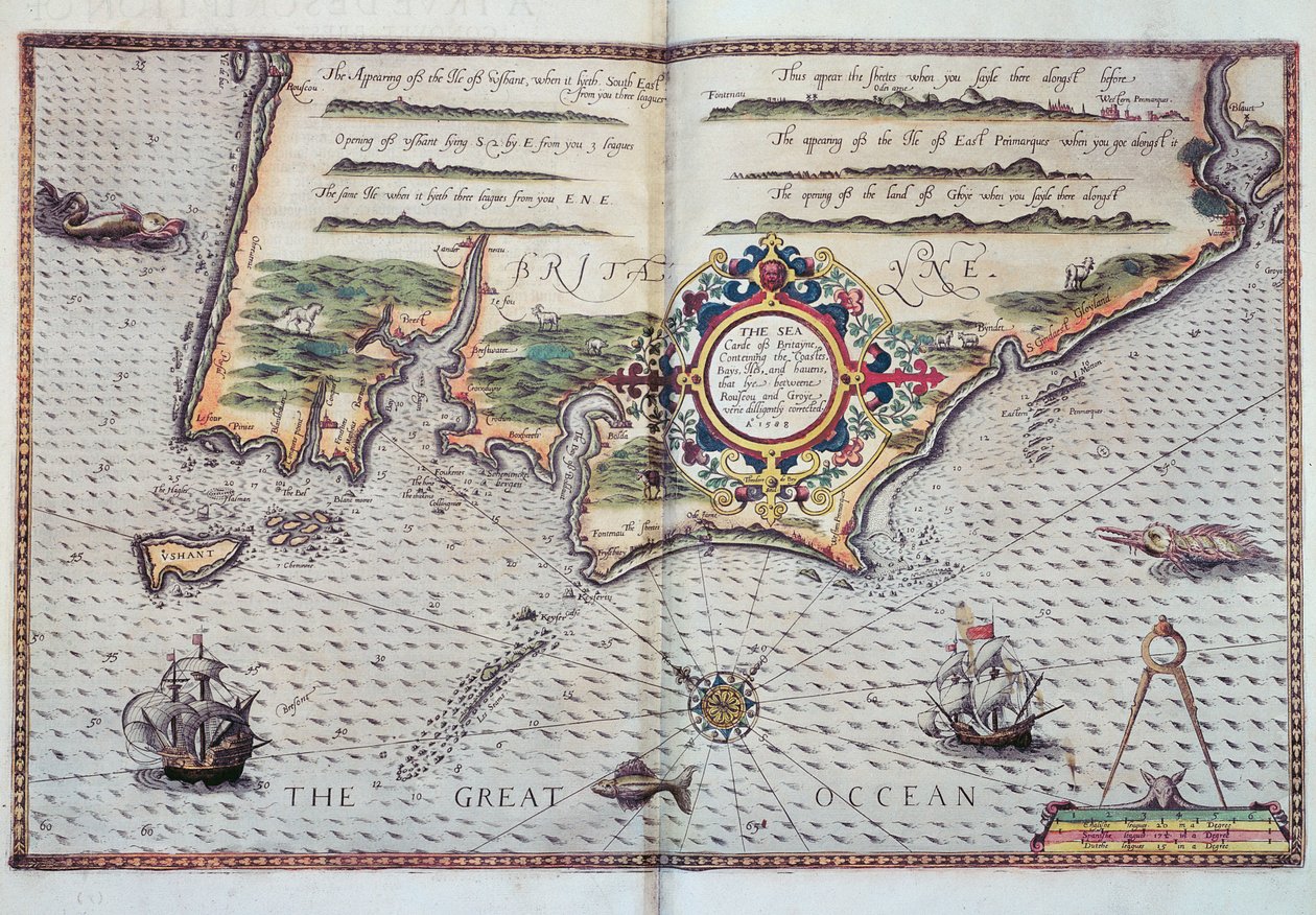
A Map of the Coastline of Brittany by European School

A Map of the Coastline of Brittany

(A Map of the coastline of Brittany, 1588)


European School

€ 124.11
Enthält 0% MwSt.
   Configure art print
1588  ·  Picture ID: 82564

Cultural Circles  ·  Cartography

A Map of the Coastline of Brittany by European School. Available as an art print on canvas, photo paper, watercolor board, uncoated paper or Japanese paper.
mapping · cartography · french · coast · breton · bretagne · northern france · atlantic ocean · great · chart · coastline · cartouche · Private Collection / Bridgeman Images
zu Favoriten hinzufügen   Add to favorites    Select wall color    View painting in a room AR/3D   View in 3D / AR
0 Reviews

Configure art print

Picture Frame

Medium & Stretcher

Glass & Passepartout

Miscellaneous & Extras

 Save / compare configuration
Preview Icon

Summary

Gemälde
Veredelung
Keilrahmen
Museumslizenz

€ 124.11
(inkl. 20% MwSt)
   Add to cart

Bildschärfe: PERFEKT

Should you desire adjustments to brightness and color, or a custom crop of the motif, we are happy to make these changes at no additional cost to you. Please do not hesitate to contact us.

Similar artworks selected for you

A Description of the Sea Coasts, of the Land of Algarve, and a Part of the County with Their Show & Opening, c.1588 The Sea Coasts of England Between the Isle of Wight and Dover, with the Principal Havens Thereof According to Their Situation and Appearing The Sea Coasts Between Dover & Orfordness: Including the Most Famous River of Thames with All the Sands, Banks, Flats, & Shoals Thereabouts According to Their True Situation and Appearance Theatrum Orbis Terrarum Coast of Prussia with all the havens and rivers from Memel to Heel Map of Livonia Straits of Magellan (engraving) Description of the Sea Coasts of Eyder Ditmers and Part of Jeverland Map of Livonia Die custe va Lijfflandt met de eijlanden daer beneffens The south coast of England Oversize Atlas Titled Theatrum Orbis Terrarum Southeast, in Dutch Trade Map of the Baltic Sea Bristol Channel Chart of the English Channel Map of North-eastern Brazil Map of the Coast of Flanders, Normandy and England The Republic of Genoa, Map by Jan Baptist Vrients from Theatrum Orbis Terrarum by Abraham Ortelius The Battle off the Isle of Wight on 4 August Map of the Coasts of Flanders, Normandy, and England St Augustine Map of the North Coast of England near Newcastle upon Tyne The English engage the Spanish fleet near Plymouth on 31 July Ischia, 1642 Chart of the Coast of England with the Sea Decorated with Ships and Monster Cape Finisterre after the portulan of Luca J. Waghenaer tresoor de zeevaert, Leiden 1592 Map of the English Coast between the Isle of Wight and Dover The English and Spanish Fleets on 1 - 2 August
Show more similar artworks

Other art prints by European School

Title page of The Tree of Science, or Arbre de la ciència or Arbor Scientiae or Arborxscientiae, by Ramon Llull c.1295, 1505 Romeo and Juliet, The Balcony Scene Prometheus released from his chains by Hercules Steller Scene from Beethoven Beethoven Monte Pincio in Rome People worshipping the seven-headed beast out of the sea Tea, 1899 Daniel in the Lions Silk production in the South of France Victoria Hotel, Amsterdam Beer, 1899 The Kingfisher Park Cattle
Discover more works by European School

Other motives from the category Cartography

Map of the Battle of Bautzen, published by William Blackwood and Sons, Edinburgh and London, 1848 Map of Gaul, Belgium, Lyon and Aquitaine Map of Philadelphia Lead Works, 1889 Map of Lime Street Ward, London India and Malaysia, from an Atlas of the World in 33 Maps, Venice, 1st September 1553 (detail) The Indian Ocean, from an Atlas of the World in 33 Maps, Venice Map of Africa, Published in 1700, Paris Reproduction of Map of Routes of St. James of Compostel, Originally Engraved by D. Serveaux 1648 German Map Showing the Extent of Surface Area and Population of the Principal Countries of Europe, c.1785 Map illustrating General Lee Map of the Eastern Part of the Roman Empire, from Septentrionalium terrarum descriptio, map of the Arctic, 1595 Renaissance map of Europe, Jacopo Russo (after) 1528 Map of West African coastline, 1596 Map of Regent
View More from "Cartography"

Excerpt from our top sellers

Ejiri in Suruga Province Two Reclining Figures Composition VIII The Sleeping Jesus, or Madonna Holding the Sleeping Child, Accompanied by Three Angels The Cliff, Étretat, Sunset Lensing Galaxy Cluster (Webb Rock at Jávea Circe Le Lavandou Quince, Cabbage, Melon, and Cucumber, c.1602 Villa by the Sea The Zaporozhye Cossacks Writing a Letter to the Turkish Sultan Witches Ghost of a Genius The Great Wave off Kanagawa
Show More Artworks


What our customers think about us


Frequently Asked Questions about Meisterdrucke


Personalizing your art print at Meisterdrucke is a simple and intuitive process that allows you to design an artwork exactly to your specifications: Choose a frame, determine the image size, decide on a printing medium, and add suitable glazing or a stretcher frame. We also offer customization options such as mats, fillets, and spacers. Our customer service is available to help you design your perfect artwork.

At Meisterdrucke, you have the fascinating option to visualize the artwork you configured directly in your own space. For a tailored preview, simply upload a photo of your room and let the artwork appear on it. If you visit us via a mobile device, be it a phone or tablet, our augmented reality feature brings the image to life and seamlessly projects it into your space. An experience that uniquely combines art and technology.

Choosing the medium is often a matter of personal taste. To give you a clearer idea, we have provided some images for each medium. For a holistic experience, we also offer you a sample set of all paper variants so you can make a decision not just visually but also haptically. You can take advantage of the sample set free of charge – only the shipping costs will apply. You can order the sample set directly.

Do not worry. At Meisterdrucke, we do not proceed mechanically. We manually review each order. If there are any inconsistencies or peculiarities in the configuration, we will immediately contact you. Of course, our courteous and patient support is always at your side to assist you with the configuration. Together with you, we adjust your image by phone or email so that the final result exactly meets your expectations.


Do you have any questions?

Are you interested in an art print from our manufactory but still unsure? Do you need advice on choosing the medium or help with the order?

Our experts are happy to assist you.

+43 4257 29415
support@meisterdrucke.com
Mo-Do: 7:00 - 16:00 | Fr: 7:00 - 13:00

Do you have any questions?

Are you interested in an art print from our manufactory but still unsure? Do you need advice on choosing the medium or help with the order?

Our experts are happy to assist you.

+43 4257 29415
support@meisterdrucke.com
Mo-Do: 7:00 - 16:00 | Fr: 7:00 - 13:00


Meisterdrucke

   Kärntner Strasse 46
        9586 Finkenstein am Faaker See
        Austria
        +43 4257 29415
        support@meisterdrucke.com
Other languages

                   
Erfahrungen & Bewertungen zu Meisterdrucke
Partner Logos

Kaiser Franz Joseph

Meisterdrucke
Kärntner Strasse 46
9586 Finkenstein am Faaker See · Austria
+43 4257 29415 · office@meisterdrucke.com
Partner Logos


(c) 2025 meisterdrucke.uk