support@meisterdrucke.com  ·  0043 4257 29415

Deutsch English Italiano Español Français Nederlands Português Svenska Polski Dansk
Search by artist, work title or style – e.g. Monet, Starry Night, Impressionism, Hokusai wave, nude. Describe the scene – e.g. green meadow, abstract with lots of red, dark oil painting, standing nude next to a tree.

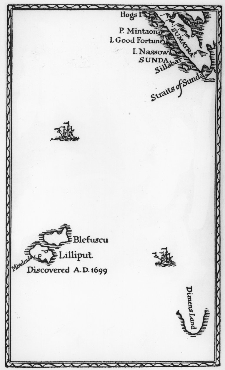
Map of Lilliput and Blefuscu, from the first edition of 'Gulliver's Travels' by Jonathan Swift, 1726 by English School

Map of Lilliput and Blefuscu, from the first edition of 'Gulliver's Travels' by Jonathan Swift, 1726

(Map of Lilliput and Blefuscu, from the first edition of 'Gulliver's Travels' by Jonathan Swift, 1726 (print))


English School

€ 120.98
Tax-free
   Configure art print
1726  ·  print  ·  Image ID: 63265

Cultural Circles  ·  Cartography

Map of Lilliput and Blefuscu, from the first edition of 'Gulliver's Travels' by Jonathan Swift, 1726 by English School. Available as an art print on canvas, photo paper, watercolor board, natural paper, or Japanese paper.
island · islands · sumatra · straits of sunda · dimens land · maps · imaginary · fictional place · places · country · countries · Private Collection / Bridgeman Images
AR/3D   View in 3D / AR zu Favoriten hinzufügen   Add to favorites    Change wall color    View picture in a room
0 Reviews

Configure art print

Picture Frame

Medium & Stretcher

Glass & Passepartout

Miscellaneous & Extras

 Save / compare configuration
Preview Icon

Summary

Gemälde
Veredelung
Keilrahmen
Museumslizenz

€ 120.98
(inkl. 20% MwSt)
   Add to cart

Bildschärfe: PERFEKT

If you'd like us to adjust the brightness, colors, or crop the image, we're happy to do this for you at no extra cost. Just get in touch!

Similar artworks selected for you

Map showing location of Lilliput from first edition of Gulliver Map of Laputa, Balnibari, Luggnagg, Glubbdubdrib and Japan, illustration from the first edition of Map showing location of the Houyhnhnms Land from first edition of Gulliver Map of Atlantis, from Map No.9 showing the route of the Armada fleet, engraved by Augustine Ryther, 1588 Map including Massachusetts Bay Map from Map of Atlantis, from Legendary Island of Atlantis Map No.10 showing the route of the Armada fleet, engraved by Augustine Ryther Map of Atlantis, from Map of Brobdingnag, illustration from the first edition of The Harbour of Cape Cod, from Voyages de Sieur Champlain by Samuel de Champlain, Published in Paris, 1613 Map No. 3 Showing the Route of the Armada Fleet, engraved by Augustine Ryther, 1588 Lewes Castle, in Sussex, Late 18th Century Map of the Galapagos Archipelago Map showing location of Brobdingnag from first edition of Gulliver Map No.6 showing the route of the Armada fleet, engraved by Augustine Ryther, 1588 Description of Isla Escudo de Veraguas by Francis Drake Map No. 5 Showing the route of the Armada fleet, engraved by Augustine Ryther, 1588 Map of an Island in the Treasure (Pirates?) Plan of Rhodes (Rodos) - in Plan of the Battle of Tamai, March 13, 1884 Map of Treasure Island, from Treasure Island by Robert Louis Stevenson, published 1883 Battle of Cape St Vincent, 1797 Chart showing the track of His Majesty Maps of Holy Island and Farne Island, Northumberland, from Map No. 2 Showing the Route of the Armada Fleet, engraved by Augustine Ryther, 1588 Easter Island, from Travel Atlas by James Cook
Show more similar artworks

Similar artworks selected for you

Map showing location of Lilliput from first edition of Gulliver Map of Laputa, Balnibari, Luggnagg, Glubbdubdrib and Japan, illustration from the first edition of Map showing location of the Houyhnhnms Land from first edition of Gulliver Map of Atlantis, from Map No.9 showing the route of the Armada fleet, engraved by Augustine Ryther, 1588 Map including Massachusetts Bay Map from Map of Atlantis, from Legendary Island of Atlantis Map No.10 showing the route of the Armada fleet, engraved by Augustine Ryther Map of Atlantis, from Map of Brobdingnag, illustration from the first edition of The Harbour of Cape Cod, from Voyages de Sieur Champlain by Samuel de Champlain, Published in Paris, 1613 Map No. 3 Showing the Route of the Armada Fleet, engraved by Augustine Ryther, 1588 Lewes Castle, in Sussex, Late 18th Century Map of the Galapagos Archipelago Map showing location of Brobdingnag from first edition of Gulliver Map No.6 showing the route of the Armada fleet, engraved by Augustine Ryther, 1588 Description of Isla Escudo de Veraguas by Francis Drake Map No. 5 Showing the route of the Armada fleet, engraved by Augustine Ryther, 1588 Map of an Island in the Treasure (Pirates?) Plan of Rhodes (Rodos) - in Plan of the Battle of Tamai, March 13, 1884 Map of Treasure Island, from Treasure Island by Robert Louis Stevenson, published 1883 Battle of Cape St Vincent, 1797 Chart showing the track of His Majesty Maps of Holy Island and Farne Island, Northumberland, from Map No. 2 Showing the Route of the Armada Fleet, engraved by Augustine Ryther, 1588 Easter Island, from Travel Atlas by James Cook
Show more similar artworks

More art prints by English School

Church and Cottage with Lighted Windows Portrait of a bodybuilder, c. 1898 The Portrait of King Richard III Kidbrooke Park, Kent, formerly attributed to George Lambert (1700-65) c.1740-50 Map of Europe in 1910 Portrait of the Greek philosopher Socrates (469-399 BC) - From the series “Leaders of Men” - Chromolithography - English School, 20th century Venice, 1338, after a manuscript in the Bodleian Library, from Map of Ireland from ’The History of Ireland’ by Thomas Wright, published c.1854 Detailed Map of Gallipoli Peninsula and the Dardanelles, Turkey, 1915, from Ever-flowering Rose (Rosa semperflorens), plate 284 from William Curtis Poster advertising ‘A Midsummer Night Romeo buys poison from the apothecary, illustration from Romeo and Juliet, from "The Illustrated Library Shakespeare", published in London 1890 Map of the world with possessions of the British Empire coloured red, c. 1870 Portrait of Queen Elizabeth I of England (1533-1603). Painting of the English School. 17th century. Canvas, 0.56 x 0.77 m. Pau, Musée du Château
Show more works by English School

More art prints by English School

Church and Cottage with Lighted Windows Portrait of a bodybuilder, c. 1898 The Portrait of King Richard III Kidbrooke Park, Kent, formerly attributed to George Lambert (1700-65) c.1740-50 Map of Europe in 1910 Portrait of the Greek philosopher Socrates (469-399 BC) - From the series “Leaders of Men” - Chromolithography - English School, 20th century Venice, 1338, after a manuscript in the Bodleian Library, from Map of Ireland from ’The History of Ireland’ by Thomas Wright, published c.1854 Detailed Map of Gallipoli Peninsula and the Dardanelles, Turkey, 1915, from Ever-flowering Rose (Rosa semperflorens), plate 284 from William Curtis Poster advertising ‘A Midsummer Night Romeo buys poison from the apothecary, illustration from Romeo and Juliet, from "The Illustrated Library Shakespeare", published in London 1890 Map of the world with possessions of the British Empire coloured red, c. 1870 Portrait of Queen Elizabeth I of England (1533-1603). Painting of the English School. 17th century. Canvas, 0.56 x 0.77 m. Pau, Musée du Château
Show more works by English School

More motifs from the category Cartography

Map of New Belgium and New England, published in Amsterdam c.1640 Map of Heilsberg, published by William Blackwood and Sons, Edinburgh and London, 1848 Iceland, from an Atlas of the World in 33 maps, Venice, 1st September 1553 (detail from 330951) Map describing the islands of Salvador, Española, Fernanda, Isabella and Conception, 1493 Map of Flissinga, from Civitates Orbis Terrarum by Georg Braun (1541-1622) and Frans Hogenberg (1535-90), c. 1572-1617 Ms. 988, Vol. 3, fol. 7 Plan and Map of the Town, Citadel and Surroundings of Amiens, from the ’Atlas Louis XIV’, 1683-88 Map of Louvain, from ’Civitates Orbis Terrarum’ by Georg Braun (1541-1622) and Frans Hogenberg (1535-90) c.1572-1617 Map of Venice, first half of 17th century (panel) (detail of 64062) Map of Suresnes and its annexe, Puteaux, 1669 Map of Florida, c. 1584 Map of Marseilles, from World map tracing Magellan Fan with maple design A Map of Samaria, from The First Western Atlas Map of China, from the Ortelius Theatrum Atlas, 1584
View More from "Cartography"

More motifs from the category Cartography

Map of New Belgium and New England, published in Amsterdam c.1640 Map of Heilsberg, published by William Blackwood and Sons, Edinburgh and London, 1848 Iceland, from an Atlas of the World in 33 maps, Venice, 1st September 1553 (detail from 330951) Map describing the islands of Salvador, Española, Fernanda, Isabella and Conception, 1493 Map of Flissinga, from Civitates Orbis Terrarum by Georg Braun (1541-1622) and Frans Hogenberg (1535-90), c. 1572-1617 Ms. 988, Vol. 3, fol. 7 Plan and Map of the Town, Citadel and Surroundings of Amiens, from the ’Atlas Louis XIV’, 1683-88 Map of Louvain, from ’Civitates Orbis Terrarum’ by Georg Braun (1541-1622) and Frans Hogenberg (1535-90) c.1572-1617 Map of Venice, first half of 17th century (panel) (detail of 64062) Map of Suresnes and its annexe, Puteaux, 1669 Map of Florida, c. 1584 Map of Marseilles, from World map tracing Magellan Fan with maple design A Map of Samaria, from The First Western Atlas Map of China, from the Ortelius Theatrum Atlas, 1584
View More from "Cartography"

A selection of our top sellers

The Harvest The Parquet Planers View from a Window, 1988 Antibes, The Fort, 1888 The Youth of Bacchus, 1884. Princess Tuvstarr Is Still Sitting There Wistfully Looking into the Water, 1913 Winter, 1573 The Entrance to the Grand Canal, Venice, ca 1730 The Buddha Pine Forest, left screen Dog The Forest of Pines Lavender Fields in Old Provence Wheatfield Study for “Passage of Humaitá”
Show more artworks

A selection of our top sellers

The Harvest The Parquet Planers View from a Window, 1988 Antibes, The Fort, 1888 The Youth of Bacchus, 1884. Princess Tuvstarr Is Still Sitting There Wistfully Looking into the Water, 1913 Winter, 1573 The Entrance to the Grand Canal, Venice, ca 1730 The Buddha Pine Forest, left screen Dog The Forest of Pines Lavender Fields in Old Provence Wheatfield Study for “Passage of Humaitá”
Show more artworks


What our customers think about us


Frequently Asked Questions about Meisterdrucke


Personalizing your art print at Meisterdrucke is simple and intuitive: Choose a frame, set the image size, pick a printing medium, and add suitable glazing or a stretcher frame. We also offer additional customization options like mats, fillets, and spacers. If you have any questions, our customer service team is ready to help you create your perfect artwork.

At Meisterdrucke, you can visualize your configured artwork directly in your own room. Simply upload a photo of your space and see how the artwork looks in it. If you're visiting us on a mobile device — phone or tablet — our augmented reality feature brings the picture to life and projects it right into your room. A unique experience that combines art and technology.

Choosing the right medium is often a matter of personal taste. To give you a better idea, we've provided some images for each medium. We also offer a sample set of all paper variants, so you can decide not just visually but by touch as well. You can order the sample set free of charge — only shipping costs apply.

Don't worry! At Meisterdrucke, we don't just process orders mechanically. Every order is manually reviewed by our team. If we spot any inconsistencies or issues with your configuration, we'll get in touch with you right away. And of course, our friendly and patient support team is always here to help you with your configuration. We'll work with you by phone or email to adjust your image so the final result is exactly what you had in mind.


Still have questions?

Are you interested in an art print from our manufactory but still unsure? Do you need advice on choosing the medium or help with the order?

Our experts are happy to assist you.

+43 4257 29415
support@meisterdrucke.com
Mo-Do: 7:00 - 16:00 | Fr: 7:00 - 13:00

Still have questions?

Are you interested in an art print from our manufactory but still unsure? Do you need advice on choosing the medium or help with the order?

Our experts are happy to assist you.

+43 4257 29415
support@meisterdrucke.com
Mo-Do: 7:00 - 16:00 | Fr: 7:00 - 13:00


Meisterdrucke

   Kärntner Strasse 46
        9586 Finkenstein am Faaker See
        Austria
        +43 4257 29415
        support@meisterdrucke.com
Other languages

                   
Erfahrungen & Bewertungen zu Meisterdrucke
Post.at DHL Express Quehenberger Cargoboard
Kaiser Franz Joseph

Meisterdrucke
Kärntner Strasse 46
9586 Finkenstein am Faaker See · Austria
+43 4257 29415 · support@meisterdrucke.com
Post.at DHL Express Quehenberger Cargoboard


(c) 2026 meisterdrucke.uk