support@meisterdrucke.com  ·  0043 4257 29415

Deutsch English Italiano Español Français Nederlands Português Svenska Polski Dansk
Search by artist, work title or style – e.g. Monet, Starry Night, Impressionism, Hokusai wave, nude. Describe the scene – e.g. green meadow, abstract with lots of red, dark oil painting, standing nude next to a tree.

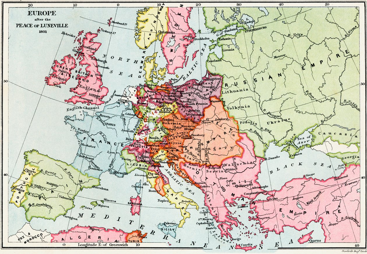
Map of Europe after the Peace of Lunéville, 1801, from 'A Short History of the English People' by J. R. Green, published 1893 by English School

Map of Europe after the Peace of Lunéville, 1801, from 'A Short History of the English People' by J. R. Green, published 1893

(Map of Europe after the Peace of Luneville, 1801, from 'A Short History of the English People' by J. R. Green, published 1893 )


English School

€ 133.83
Tax-free
   Configure art print
1893  ·  colour lithograph  ·  Image ID: 54662

Cultural Circles  ·  Cartography

Map of Europe after the Peace of Lunéville, 1801, from 'A Short History of the English People' by J. R. Green, published 1893 by English School. Available as an art print on canvas, photo paper, watercolor board, natural paper, or Japanese paper.
cartography · historical · european · treaty · country · countries · region · regions · territories · territory · empire · empires · diagram · illustration · borders · frontiers · Private Collection / Bridgeman Images
Other color versions of this image  
AR/3D   View in 3D / AR zu Favoriten hinzufügen   Add to favorites    Change wall color    View picture in a room
0 Reviews

Configure art print

Picture Frame

Medium & Stretcher

Glass & Passepartout

Miscellaneous & Extras

 Save / compare configuration
Preview Icon

Summary

Gemälde
Veredelung
Keilrahmen
Museumslizenz

€ 133.83
(inkl. 20% MwSt)
   Add to cart

Bildschärfe: PERFEKT

If you'd like us to adjust the brightness, colors, or crop the image, we're happy to do this for you at no extra cost. Just get in touch!

Similar artworks selected for you

Map of Central Europe, c. 1914 Map of the extent of the Hanseatic League in about 1400 Map of the Extent of the Hanseatic League in About 1400 Map of Europe in 1910 Central Europe and the Mediterranean Central Europe showing the historic sites and battlefields of 1792-1813 - engraving in Europe in 814 - Empires of the West and the East - Plate extracted from Atlas of Europe in 814: Empires of the West and the East. From Volkerkarte von Russland. 1881 A Europe and the Orient at the time of the 3rd Great Crusade at the end of the 13th century - Map prepared by M. J.-H. Schnitzler, Historical and Picturesque Atlas, 1858 Map of Physical Europe Map of the dominions of the Angevins, c. 1170, from The Empire of Charlemagne, from Atlas Historique et Pittoresque, by M J-H Schnitzler, 1857 The Dominions of the Angevins, 1892 Map of Europe, 1902 Modern Europe Europe, from Johnson Map of Great Britain showing the dominions of William the Conqueror, c. 1087, from Historical Atlas, published 1923 Map of Central Europe, Showing the Principal Theatre of War, 1919 Europe Map of Russia, 1902 Europe After the Invasion of the Barbarians in the 6th Century - Plate Extracted from Geographic map of Europe at the time of Napoleon I. In “Atlante Storico Geografico” by K. von Sruner Geographic Map of Europe in the 1870s. 19th-Century Colour Lithography England during the Civil War, 1642-1649 Map of Ancient Greece, 1902
Show more similar artworks

Similar artworks selected for you

Map of Central Europe, c. 1914 Map of the extent of the Hanseatic League in about 1400 Map of the Extent of the Hanseatic League in About 1400 Map of Europe in 1910 Central Europe and the Mediterranean Central Europe showing the historic sites and battlefields of 1792-1813 - engraving in Europe in 814 - Empires of the West and the East - Plate extracted from Atlas of Europe in 814: Empires of the West and the East. From Volkerkarte von Russland. 1881 A Europe and the Orient at the time of the 3rd Great Crusade at the end of the 13th century - Map prepared by M. J.-H. Schnitzler, Historical and Picturesque Atlas, 1858 Map of Physical Europe Map of the dominions of the Angevins, c. 1170, from The Empire of Charlemagne, from Atlas Historique et Pittoresque, by M J-H Schnitzler, 1857 The Dominions of the Angevins, 1892 Map of Europe, 1902 Modern Europe Europe, from Johnson Map of Great Britain showing the dominions of William the Conqueror, c. 1087, from Historical Atlas, published 1923 Map of Central Europe, Showing the Principal Theatre of War, 1919 Europe Map of Russia, 1902 Europe After the Invasion of the Barbarians in the 6th Century - Plate Extracted from Geographic map of Europe at the time of Napoleon I. In “Atlante Storico Geografico” by K. von Sruner Geographic Map of Europe in the 1870s. 19th-Century Colour Lithography England during the Civil War, 1642-1649 Map of Ancient Greece, 1902
Show more similar artworks

More art prints by English School

Church and Cottage with Lighted Windows Portrait of a bodybuilder, c. 1898 The Portrait of King Richard III Kidbrooke Park, Kent, formerly attributed to George Lambert (1700-65) c.1740-50 Map of Europe in 1910 Portrait of the Greek philosopher Socrates (469-399 BC) - From the series “Leaders of Men” - Chromolithography - English School, 20th century Map of Ireland from ’The History of Ireland’ by Thomas Wright, published c.1854 Map of the world with possessions of the British Empire coloured red, c. 1870 Poster advertising ‘A Midsummer Night Venice, 1338, after a manuscript in the Bodleian Library, from Detailed Map of Gallipoli Peninsula and the Dardanelles, Turkey, 1915, from Winston Churchill on horseback in Bangalore, India in 1897, from ’A Roving Commission by Winston S. Churchill’, published by Scribner’s, 1930 Romeo buys poison from the apothecary, illustration from Romeo and Juliet, from "The Illustrated Library Shakespeare", published in London 1890 Portrait of King James II, c. 1690
Show more works by English School

More art prints by English School

Church and Cottage with Lighted Windows Portrait of a bodybuilder, c. 1898 The Portrait of King Richard III Kidbrooke Park, Kent, formerly attributed to George Lambert (1700-65) c.1740-50 Map of Europe in 1910 Portrait of the Greek philosopher Socrates (469-399 BC) - From the series “Leaders of Men” - Chromolithography - English School, 20th century Map of Ireland from ’The History of Ireland’ by Thomas Wright, published c.1854 Map of the world with possessions of the British Empire coloured red, c. 1870 Poster advertising ‘A Midsummer Night Venice, 1338, after a manuscript in the Bodleian Library, from Detailed Map of Gallipoli Peninsula and the Dardanelles, Turkey, 1915, from Winston Churchill on horseback in Bangalore, India in 1897, from ’A Roving Commission by Winston S. Churchill’, published by Scribner’s, 1930 Romeo buys poison from the apothecary, illustration from Romeo and Juliet, from "The Illustrated Library Shakespeare", published in London 1890 Portrait of King James II, c. 1690
Show more works by English School

More motifs from the category Cartography

Atlas 131 fol. 13, Map of Saintes, capital of Saintonge, from Map of the Old and New Worlds, c. 1500 Map of Florence, 1843 and 1866 (for detail see 100311) Map of Paris, 1723 Map showing the route of the Armada fleet, engraved by Augustine Ryther, 1588 Map of Russia and Eastern Europe from Atlas Minor, 1745 Inc. 425 Map of the Holy Land, based on descriptions and co-ordinates given in Cosmographica, by Ptolemy (Claudius Ptolemaeus of Alexandria) (c. 90-168 AD), published in Ulm, Germany, by Johann Reger fo A New and Correct Map of the World Laid Down According to the Newest Discoveries and from the Most Exact Observations, 1736 A Map of Limehouse and Rotherhithe, London, 1746 Map of the Indian Peninsula, 1733 Ms. 1288, fol. 1: The Polar Aurora, Detail of England, Ireland and Norway, from a Collection of Dutch Marine Maps, Engraving World Map, early 18th century Map of Europe after the Peace of Lunéville, 1801, from Map of Silesia, from an Atlas Map of Britain in 640, from “The Northumbrian Kingdom” in “A Short History of the English People” by J. R. Green, published 1893
View More from "Cartography"

More motifs from the category Cartography

Atlas 131 fol. 13, Map of Saintes, capital of Saintonge, from Map of the Old and New Worlds, c. 1500 Map of Florence, 1843 and 1866 (for detail see 100311) Map of Paris, 1723 Map showing the route of the Armada fleet, engraved by Augustine Ryther, 1588 Map of Russia and Eastern Europe from Atlas Minor, 1745 Inc. 425 Map of the Holy Land, based on descriptions and co-ordinates given in Cosmographica, by Ptolemy (Claudius Ptolemaeus of Alexandria) (c. 90-168 AD), published in Ulm, Germany, by Johann Reger fo A New and Correct Map of the World Laid Down According to the Newest Discoveries and from the Most Exact Observations, 1736 A Map of Limehouse and Rotherhithe, London, 1746 Map of the Indian Peninsula, 1733 Ms. 1288, fol. 1: The Polar Aurora, Detail of England, Ireland and Norway, from a Collection of Dutch Marine Maps, Engraving World Map, early 18th century Map of Europe after the Peace of Lunéville, 1801, from Map of Silesia, from an Atlas Map of Britain in 640, from “The Northumbrian Kingdom” in “A Short History of the English People” by J. R. Green, published 1893
View More from "Cartography"

A selection of our top sellers

Girl by a Birch Trunk (also: Girl at a Tree) Animal Fable: Tiger and Snake in Combat in a Primeval Forest The Accolade, 1901. The Great Wave off Kanagawa, c.1830 Psyche entering Cupid Impression: Sunrise, 1872 Wintry Full Moon Landscape The Seasons: Summer, 1896 Portrait of Joan of Arc with flag and lilies against the background of Notre-Dame Cathedral Resting Figure, 1930 The Divine Comedy, Paradiso, Canto 31: The saintly throng form a rose in the empyrean (celestial rose) - by Dante Alighieri (1265-1321) View of Delft The Resurrection of Christ, from the right wing of the Isenheim Altarpiece, c.1512-16, detail of 17677 Childhood Friends Coffee Garden at Lake Ammer
Show more artworks

A selection of our top sellers

Girl by a Birch Trunk (also: Girl at a Tree) Animal Fable: Tiger and Snake in Combat in a Primeval Forest The Accolade, 1901. The Great Wave off Kanagawa, c.1830 Psyche entering Cupid Impression: Sunrise, 1872 Wintry Full Moon Landscape The Seasons: Summer, 1896 Portrait of Joan of Arc with flag and lilies against the background of Notre-Dame Cathedral Resting Figure, 1930 The Divine Comedy, Paradiso, Canto 31: The saintly throng form a rose in the empyrean (celestial rose) - by Dante Alighieri (1265-1321) View of Delft The Resurrection of Christ, from the right wing of the Isenheim Altarpiece, c.1512-16, detail of 17677 Childhood Friends Coffee Garden at Lake Ammer
Show more artworks


What our customers think about us


Frequently Asked Questions about Meisterdrucke


Personalizing your art print at Meisterdrucke is simple and intuitive: Choose a frame, set the image size, pick a printing medium, and add suitable glazing or a stretcher frame. We also offer additional customization options like mats, fillets, and spacers. If you have any questions, our customer service team is ready to help you create your perfect artwork.

At Meisterdrucke, you can visualize your configured artwork directly in your own room. Simply upload a photo of your space and see how the artwork looks in it. If you're visiting us on a mobile device — phone or tablet — our augmented reality feature brings the picture to life and projects it right into your room. A unique experience that combines art and technology.

Choosing the right medium is often a matter of personal taste. To give you a better idea, we've provided some images for each medium. We also offer a sample set of all paper variants, so you can decide not just visually but by touch as well. You can order the sample set free of charge — only shipping costs apply.

Don't worry! At Meisterdrucke, we don't just process orders mechanically. Every order is manually reviewed by our team. If we spot any inconsistencies or issues with your configuration, we'll get in touch with you right away. And of course, our friendly and patient support team is always here to help you with your configuration. We'll work with you by phone or email to adjust your image so the final result is exactly what you had in mind.


Still have questions?

Are you interested in an art print from our manufactory but still unsure? Do you need advice on choosing the medium or help with the order?

Our experts are happy to assist you.

+43 4257 29415
support@meisterdrucke.com
Mo-Do: 7:00 - 16:00 | Fr: 7:00 - 13:00

Still have questions?

Are you interested in an art print from our manufactory but still unsure? Do you need advice on choosing the medium or help with the order?

Our experts are happy to assist you.

+43 4257 29415
support@meisterdrucke.com
Mo-Do: 7:00 - 16:00 | Fr: 7:00 - 13:00


Meisterdrucke

   Kärntner Strasse 46
        9586 Finkenstein am Faaker See
        Austria
        +43 4257 29415
        support@meisterdrucke.com
Other languages

                   
Erfahrungen & Bewertungen zu Meisterdrucke
Post.at DHL Express Quehenberger Cargoboard
Kaiser Franz Joseph

Meisterdrucke
Kärntner Strasse 46
9586 Finkenstein am Faaker See · Austria
+43 4257 29415 · support@meisterdrucke.com
Post.at DHL Express Quehenberger Cargoboard


(c) 2026 meisterdrucke.uk