Search by artist, work title or style – e.g. Monet, Starry Night, Impressionism, Hokusai wave, nude. Describe the scene – e.g. green meadow, abstract with lots of red, dark oil painting, standing nude next to a tree.

Chart showing the sea coast of England and Wales, plate from

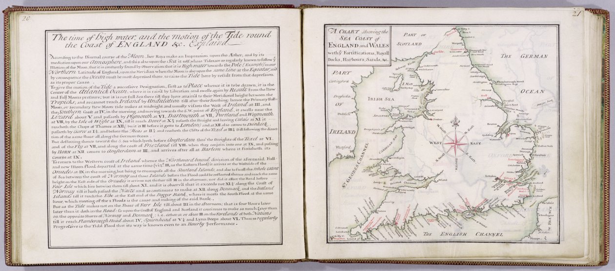
Chart showing the sea coast of England and Wales, plate from 'A Compleat Sett of Mapps of England and Wales in General...', 1724

(Chart showing the sea coast of England and Wales, plate from 'A Compleat Sett of Mapps of England and Wales in General...', 1724 (pen und ink and wc on paper))


Thomas Badeslade

€ 97.4
Enthält 0% MwSt.
   Configure art print
1724  ·  pen and ink and watercolour on paper  ·  Picture ID: 41908

Nonclassified artists  ·  Cartography

Chart showing the sea coast of England and Wales, plate from 'A Compleat Sett of Mapps of England and Wales in General...', 1724 by Thomas Badeslade. Available as an art print on canvas, photo paper, watercolor board, uncoated paper or Japanese paper.
text · complete · maps · cartography · mapping · coastline · english channel · german ocean · irish sea · county · counties · British Isles · Yale Center for British Art, Paul Mellon Collection, USA / Bridgeman Images
AR/3D   View in 3D / AR zu Favoriten hinzufügen   Add to favorites    Select wall color    View painting in a room
0 Reviews

Configure art print

Picture Frame

Medium & Stretcher

Glass & Passepartout

Miscellaneous & Extras

 Save / compare configuration
Preview Icon

Summary

Gemälde
Veredelung
Keilrahmen
Museumslizenz

€ 97.4
(inkl. 20% MwSt)
   Add to cart

Bildschärfe: PERFEKT

Should you desire adjustments to brightness and color, or a custom crop of the motif, we are happy to make these changes at no additional cost to you. Please do not hesitate to contact us.

Similar artworks selected for you

Map of France, c.1693 Isle of Juan Fernandes Pages from The Western Pilot..., by Samuel Cummings, Published by G. Conclin, Cincinnati The Bay of Saints Europe, from Cosmographia, 1544 Map of Christiansø with Text Side Leaves 3v & 4r, from Divers Voyages Touching the Discouerie of America... 1582 Map of the Coast of New Zealand, Illustration from A Journal of a Voyage to the South Seas: In His Majesty Vavassore Chart of the Mediterranean Sea, Believed to Be the Earliest Surviving Printed Chart Map of the Holy Land, based on descriptions and co-ordinates given in Cosmographica, by Ptolemy (Claudius Ptolemaeus of Alexandria) published in Ulm, Germany, by Johann Reger Cosmographia, detail of Galliae A Prospect of the Castle of St Sebastien from the South & Groundplatt of the Town and Harbor Saharan Mission Manglares, Bahia de Ancon de Sardinas Tabula Prima Europa, from The London Gazette, issue 5655, page 1, 28th June 1718 Passao The London Gazette, issue 5573, page 1 Picoaza A Map of the Country of the Five Nations, belonging to the Province of New York; and of the Lakes near which the Nations of Far Indians live, with part of Canada A Chart of the Sea Coasts of Russia, Lapland, Finmarke, Nova Zemla and Greenland, 1671 Cosmographia, Col 1113, 1544 St Helena A Description of the Sea Coasts in the East Indies Hand drawn map of the coasts of Portugal and Spain, 1756 Guayaquil R Collection of Locksmith Ischia, 1642 Holy Island and Lindisfarne, in
Show more similar artworks

Other art prints by Thomas Badeslade

View of Belvoir Castle from the South West, with Belvoir Hunt in Full Cry, 1730 Kent, plate 39r, from A Compleat Sett of Mapps of England and Wales in General..., 1724 Chart showing the sea coast of England and Wales, plate from Title Page of A Compleat Sett of Mapps of England and Wales in General... Tunbridge Wells, from The West Prospect of Knole, from Front cover of A Compleat Sett of Mapps of England and Wales in General... Broome, the seat of Sir Basil Dixwell, from Tunbridge Wells, from
Discover more works by Thomas Badeslade

Other motives from the category Cartography

Plan and Map of Toulon, from the Zodiac Calendar, from an Atlas of the World in 33 Maps, Venice, 1st September 1553 Northern Europe, from an Atlas of the World in 33 maps, Venice, 1st September 1553 (ink on vellum) The Holy Land, from an Atlas of the World in 33 Maps, Venice Nova Scotia and Newfoundland, from a Series of World Maps published by John Tallis und Co., New York and London, 1850s Map of South Kensington Map from Gulliver Map of the coast of Guyana, illustration from Regni Guianae by G. Raleigh Map of Laputa, Balnibari, Luggnagg, Glubbdubdrib and Japan, illustration from the first edition of Map of the Wards of Coleman Street and Bassishaw, London Map showing the route of the Armada fleet, engraved by Augustine Ryther, 1588 Geological Map of the Kutch Region of India, Geological Survey of India 1868-69 A Map of the Island of Juan Fernandez, Printed in Part of the Tabula Peutingeriana, an illustrated itinerarium of the road network in the Roman Empire. Detail of Italy from the Peutinger map copy Map of the World, designed by Sebastien Cabot (c.1476-1557), 1544
View More from "Cartography"

Excerpt from our top sellers

Sheerness as Seen from the Nore After the Bath F. Goya, Dog Death and Life, c.1911 The Creation of the World Representing the Cosmic Sphere of the Earth (Back Panels of the Triptych Divine Mercy The School of Athens The Eruption of the Soufriere Mountains in the Island of St. Vincent, 30th April 1812 Circe Invidiosa The Apple Harvest The Isle of the Dead, Fifth Version, 1886 By the Beach Under the Wave off Kanagawa Calla Lilies, Mexico City, 1925 View of Dresden by Moonlight
Show More Artworks


What our customers think about us


Frequently Asked Questions about Meisterdrucke


Personalizing your art print at Meisterdrucke is a simple and intuitive process that allows you to design an artwork exactly to your specifications: Choose a frame, determine the image size, decide on a printing medium, and add suitable glazing or a stretcher frame. We also offer customization options such as mats, fillets, and spacers. Our customer service is available to help you design your perfect artwork.

At Meisterdrucke, you have the fascinating option to visualize the artwork you configured directly in your own space. For a tailored preview, simply upload a photo of your room and let the artwork appear on it. If you visit us via a mobile device, be it a phone or tablet, our augmented reality feature brings the image to life and seamlessly projects it into your space. An experience that uniquely combines art and technology.

Choosing the medium is often a matter of personal taste. To give you a clearer idea, we have provided some images for each medium. For a holistic experience, we also offer you a sample set of all paper variants so you can make a decision not just visually but also haptically. You can take advantage of the sample set free of charge – only the shipping costs will apply. You can order the sample set directly.

Do not worry. At Meisterdrucke, we do not proceed mechanically. We manually review each order. If there are any inconsistencies or peculiarities in the configuration, we will immediately contact you. Of course, our courteous and patient support is always at your side to assist you with the configuration. Together with you, we adjust your image by phone or email so that the final result exactly meets your expectations.


Do you have any questions?

Are you interested in an art print from our manufactory but still unsure? Do you need advice on choosing the medium or help with the order?

Our experts are happy to assist you.

+43 4257 29415
support@meisterdrucke.com
Mo-Do: 7:00 - 16:00 | Fr: 7:00 - 13:00

Do you have any questions?

Are you interested in an art print from our manufactory but still unsure? Do you need advice on choosing the medium or help with the order?

Our experts are happy to assist you.

+43 4257 29415
support@meisterdrucke.com
Mo-Do: 7:00 - 16:00 | Fr: 7:00 - 13:00


Meisterdrucke

   Kärntner Strasse 46
        9586 Finkenstein am Faaker See
        Austria
        +43 4257 29415
        support@meisterdrucke.com
Other languages

                   
Erfahrungen & Bewertungen zu Meisterdrucke
Post.at DHL Express Quehenberger Cargoboard
Kaiser Franz Joseph

Meisterdrucke
Kärntner Strasse 46
9586 Finkenstein am Faaker See · Austria
+43 4257 29415 · office@meisterdrucke.com
Post.at DHL Express Quehenberger Cargoboard


Meisterdrucke 2734 Bewertungen auf ProvenExpert.com

(c) 2025 meisterdrucke.uk