Search by artist, work title or style – e.g. Monet, Starry Night, Impressionism, Hokusai wave, nude. Describe the scene – e.g. green meadow, abstract with lots of red, dark oil painting, standing nude next to a tree.

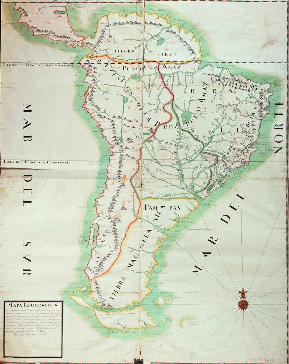
Map of South America, 1777 by Spanish School

Map of South America, 1777

(Map of South America, 1777 (wc, gouache and pen und ink on paper))


Spanish School

€ 116.33
Enthält 0% MwSt.
   Configure art print
1777  ·  watercolour, gouache and pen and ink on paper  ·  Picture ID: 64421

Cultural Circles  ·  Cartography

Map of South America, 1777 by Spanish School. Available as an art print on canvas, photo paper, watercolor board, uncoated paper or Japanese paper.
geographic · pacific · atlantic ocean · amazon river · andes · mountain range · mountains · Museo Naval, Madrid, Spain / Bridgeman Images
AR/3D   View in 3D / AR zu Favoriten hinzufügen   Add to favorites    Select wall color    View painting in a room
0 Reviews

Configure art print

Picture Frame

Medium & Stretcher

Glass & Passepartout

Miscellaneous & Extras

 Save / compare configuration
Preview Icon

Summary

Gemälde
Veredelung
Keilrahmen
Museumslizenz

€ 116.33
(inkl. 20% MwSt)
   Add to cart

Bildschärfe: PERFEKT

Should you desire adjustments to brightness and color, or a custom crop of the motif, we are happy to make these changes at no additional cost to you. Please do not hesitate to contact us.

Similar artworks selected for you

Map of Brazil Paraguay and Chile Chile (except north), Argentina, Paraguay, Uruguay, Southeast Brazil, Falkland Islands Peru, Brazil and Amazonia Map of Paraguay, Chile and Magellan Land (Argentina) (etching) Chile, from the South of Peru to Cape Horn, from Map of South America Chart of Paraguay, Chile, Straits of Magellan and Tierra del Fuego in South America South America - by A Map of the Kingdom of Valencia and Murcia (Spain) Map of South America, c.1715 Paraguay, Chile, the Land, and the Magellanic Islands: Taken from Various Accounts Map of Southern Africa (published in Strasbourg in 1522) Panama, Argentina, Bolivia, Brazil, Chile, Colombia, Ecuador, French Guiana, Guyana, Paraguay, Peru, Suriname, Uruguay, Venezuela Congo (South Africa) Southern India and Sri Lanka Map of the Indian Peninsula, 1733 South America, from Valencia and Castile, Spain Map of the Amazon Basin, 1680 Map of South America, published in 1700, Paris Map of South America South Gabon, Large Part of Republic of the Congo, Large Part of Democratic Republic of the Congo, Large Part of Uganda, Large Part of Kenya, South Somalia, Rwanda, Burundi, Tanzania, Angola Outlines of the Physical and Political Divisions of South America South America: Drawn from Observations by Members of the Royal Academy of Sciences A New Map of Mexico and Adjacent Provinces Map of Meridional Africa with the island of Madagascar Map of Southern India and Ceylon, after Adriaan Reland South America, by Guillaume de l
Show more similar artworks

Other art prints by Spanish School

Cristo de Burgos, in the Capilla del Santisimo Cristo Map of Tenochtitlan and the Gulf of Mexico, from Praeclara Ferdinadi Cortesii de Nova maris Oceani Hyspania Narratio by Hernando Cortes (1485-1547) 1524 Map Showing the Route of Christopher Columbus on His First Voyage to the New World Teresa of Ávila Genealogy of the Inca Rulers and Their Spanish Successors from Manco Capac to Ferdinand VI of Spain, c.1750 Anacaona, the Golden Flower One of Two Pink Qur Angels and David with the Ark of the Covenant standing before the Temple of Solomon, from the Visigothic-Mozarabic Bible of St. Isidores, A.D. 960 The Hand of God (Detail) Map of the Island of Mallorca, 1785 Game of pelota in the open air, from the manuscript made under the direction of Alfonso X The Wise, King of Castile and Leon Portrait of Christopher Columbus Assassination of Julius Caesar Arrival of Columbus in America, 1492 Golden Coin from Spain: Reign of Catholic Kings Ferdinand and Isabella
Discover more works by Spanish School

Other motives from the category Cartography

A Map of the Countries Thirty Degrees round the North Pole, from Map of the Battle of Trafalgar, published by William Blackwood and Sons, Edinburgh and London, 1848 Map of the State of Texas, 1835 Map No.4 Showing the Route of the Armada Fleet, Engraved by Augustine Ryther Map of the Strait of Magellan City Map of Ancient Jerusalem, from Maps of the Battle of Gross Beeren and Battle of Dennewitz, published by William Blackwood and Sons, Edinburgh and London, 1848 Map of Berlin and Coelln, 1652 Map Showing the Kremlin, Moscow Map of Belluno, from Map of the theatre of the Boer War Map of America, 1878 Map of Brazil, from Dutch Marine Maps, 1637 A Map of the World, Corrected from the Observations Communicated to the Royal Societies of London and Paris, to the Right Honourable Richard Boyle Map of Lyon
View More from "Cartography"

Excerpt from our top sellers

The Starry Night, June 1889 The Apple Harvest The School Exam Blooming Cherry Tree The Luncheon: Monet Seascape near Les Saintes-Maries-de-la-Mer Rosa centifolia foliacea, from Les Roses, 1817-24 Cliff Walk at Pourville The Times of Day: The Morning The Course of Empire: The Arcadian or Pastoral State Pandemonium The Magpie Flute Concert with Frederick the Great in Sanssouci, 1850-1852 Spring, Flora Picking Flowers Trail in the Woods
Show More Artworks


What our customers think about us


Frequently Asked Questions about Meisterdrucke


Personalizing your art print at Meisterdrucke is a simple and intuitive process that allows you to design an artwork exactly to your specifications: Choose a frame, determine the image size, decide on a printing medium, and add suitable glazing or a stretcher frame. We also offer customization options such as mats, fillets, and spacers. Our customer service is available to help you design your perfect artwork.

At Meisterdrucke, you have the fascinating option to visualize the artwork you configured directly in your own space. For a tailored preview, simply upload a photo of your room and let the artwork appear on it. If you visit us via a mobile device, be it a phone or tablet, our augmented reality feature brings the image to life and seamlessly projects it into your space. An experience that uniquely combines art and technology.

Choosing the medium is often a matter of personal taste. To give you a clearer idea, we have provided some images for each medium. For a holistic experience, we also offer you a sample set of all paper variants so you can make a decision not just visually but also haptically. You can take advantage of the sample set free of charge – only the shipping costs will apply. You can order the sample set directly.

Do not worry. At Meisterdrucke, we do not proceed mechanically. We manually review each order. If there are any inconsistencies or peculiarities in the configuration, we will immediately contact you. Of course, our courteous and patient support is always at your side to assist you with the configuration. Together with you, we adjust your image by phone or email so that the final result exactly meets your expectations.


Do you have any questions?

Are you interested in an art print from our manufactory but still unsure? Do you need advice on choosing the medium or help with the order?

Our experts are happy to assist you.

+43 4257 29415
support@meisterdrucke.com
Mo-Do: 7:00 - 16:00 | Fr: 7:00 - 13:00

Do you have any questions?

Are you interested in an art print from our manufactory but still unsure? Do you need advice on choosing the medium or help with the order?

Our experts are happy to assist you.

+43 4257 29415
support@meisterdrucke.com
Mo-Do: 7:00 - 16:00 | Fr: 7:00 - 13:00


Meisterdrucke

   Kärntner Strasse 46
        9586 Finkenstein am Faaker See
        Austria
        +43 4257 29415
        support@meisterdrucke.com
Other languages

                   
Erfahrungen & Bewertungen zu Meisterdrucke
Post.at DHL Express Quehenberger Cargoboard
Kaiser Franz Joseph

Meisterdrucke
Kärntner Strasse 46
9586 Finkenstein am Faaker See · Austria
+43 4257 29415 · office@meisterdrucke.com
Post.at DHL Express Quehenberger Cargoboard


Meisterdrucke 2764 Bewertungen auf ProvenExpert.com

(c) 2025 meisterdrucke.uk