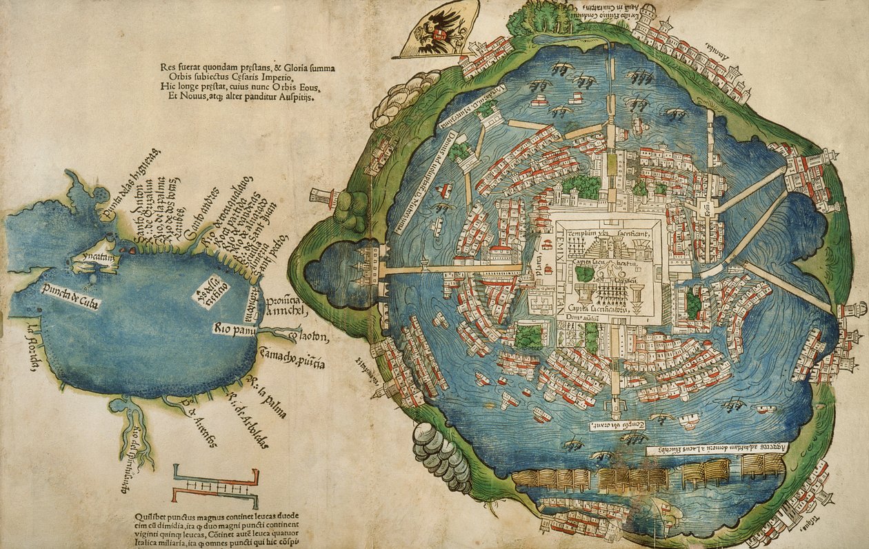
Map of Tenochtitlan and the Gulf of Mexico, from Praeclara Ferdinadi Cortesii de Nova maris Oceani Hyspania Narratio by Hernando Cortes (1485-1547) 1524 by Spanish School

Map of Tenochtitlan and the Gulf of Mexico, from Praeclara Ferdinadi Cortesii de Nova maris Oceani Hyspania Narratio by Hernando Cortes (1485-1547) 1524

(Map of Tenochtitlan and the Gulf of Mexico, from Praeclara Ferdinadi Cortesii de Nova maris Oceani Hyspania Narratio by Hernando Cortes (1485-1547) 1524 )


Spanish School

€ 115.23
Enthält 0% MwSt.
   Configure art print
1524  ·  colour lithograph  ·  Picture ID: 430851

Cultural Circles  ·  Cartography

Map of Tenochtitlan and the Gulf of Mexico, from Praeclara Ferdinadi Cortesii de Nova maris Oceani Hyspania Narratio by Hernando Cortes (1485-1547) 1524 by Spanish School. Available as an art print on canvas, photo paper, watercolor board, uncoated paper or Japanese paper.
hernan · exploration · early · cartography · chart · city · town · aztec · capital · mexico city · island · conquistadors · Newberry Library, Chicago, Illinois, USA / Bridgeman Images
zu Favoriten hinzufügen   Add to favorites    Select wall color    View painting in a room AR/3D   View in 3D / AR
0 Reviews

Configure art print

Picture Frame

Medium & Stretcher

Glass & Passepartout

Miscellaneous & Extras

 Save / compare configuration
Preview Icon

Summary

Gemälde
Veredelung
Keilrahmen
Museumslizenz

€ 115.23
(inkl. 20% MwSt)
   Add to cart

Bildschärfe: PERFEKT

Should you desire adjustments to brightness and color, or a custom crop of the motif, we are happy to make these changes at no additional cost to you. Please do not hesitate to contact us.

Similar artworks selected for you

Plan of Mexico, in Hernando Cortés, La Preclara Narratione di Ferdinando Cortese della Nuova Hispagna, Venice Map of Tenochtitlan from Plan of Constantinople Algiers, Algeria View of Algiers, Algeria Map of Algiers - Algeria (engraving) Island, Khalkis, Dalmatia Siege of Malta (detail) Map of Jerusalem and the Surrounding Area, from Map of Algiers from Zwolle, Netherlands - in Map of Tunis, Tunisia, from Civitates Orbis Terrarum, engraving Map of Messina, from Venice, Italy Plan of Venice, Italy Map of Jerusalem and the Surrounding Area, from Zwolle, Netherlands (engraving) Circular Map of Vienna during the Turkish siege Enkhuizen, Netherlands - in City of Quinsai, Engraving from La Cosmographie Universelle by Andre Thevet Map of Toledo, from Enkhuizen, Netherlands (engraving) Chart of Algiers Bay Brielle, Netherlands Messina, Italy Flemish, Belgium - in Map of Messina, Italy Ostia, Italy - in A View of Venice
Show more similar artworks

Other art prints by Spanish School

Cristo de Burgos, in the Capilla del Santisimo Cristo Map of Tenochtitlan and the Gulf of Mexico, from Praeclara Ferdinadi Cortesii de Nova maris Oceani Hyspania Narratio by Hernando Cortes (1485-1547) 1524 Map Showing the Route of Christopher Columbus on His First Voyage to the New World Genealogy of the Inca Rulers and Their Spanish Successors from Manco Capac to Ferdinand VI of Spain, c.1750 Angels and David with the Ark of the Covenant standing before the Temple of Solomon, from the Visigothic-Mozarabic Bible of St. Isidores, A.D. 960 Game of pelota in the open air, from the manuscript made under the direction of Alfonso X The Wise, King of Castile and Leon The Hand of God (Detail) Anacaona, the Golden Flower Map of the Island of Mallorca, 1785 Tomb of the Navigator Christopher Columbus The Red Fly Empress Theodora, Wife of the Byzantine Emperor Justinian I Beatriz Enriquez de Arana, mistress of Columbus Assassination of Julius Caesar Signature and Monogram of Christopher Columbus
Discover more works by Spanish School

Other motives from the category Cartography

Map Depicting the Ptolemaic and Tycho Brahe Systems of Planetary Orbit, 1701 Map of Suresnes and its annexe, Puteaux, 1669 Map of the Battle of Fere Champenoise and the Battle of Arcis-Sur-Aube, published by William Blackwood and Sons, Edinburgh and London, 1848 Map of Australia and New Zealand Map of Canaan, or Palestine, published by A.K Johnstone Map of the World, 1486 Map of Jerusalem and Palestine, Including the Sacred Sites and the Temple of Solomon A Map of Fulham, London, 1813 Map of the Siege of Toulon, published by William Blackwood and Sons, Edinburgh and London, 1848 Map of Rhode Island at the time of its occupation 1780-81 by the French Army on the orders of Jean-Baptiste de Vimeur Count of Rochambeau Map of South America showing its political divisions from Mitchell Maps of the Battle of Gross Beeren and Battle of Dennewitz, published by William Blackwood and Sons, Edinburgh and London, 1848 Map of Lower Egypt and part of Syria, published by William Blackwood and Sons Map of Iceland Feudal France at the time of the Accession of Hugues Capet in 987, map illustrated in a Histoire de France c.1880
View More from "Cartography"

Excerpt from our top sellers

A Corner of the Garden at Montgeron, 1876-7 Morning amongst the Coniston Fells, Cumberland The Stadtbahn Pavilion of the Vienna Underground Railway, Design Showing the Exterior and a View of the Railway Platform, c.1894-97 The Incredulity of St. Thomas, 1602-03 Farm Garden with Sunflowers The Three Sisters on the Beach Stein on the Danube (District of Krems) The Tortoise Trainer Baku agitation panel The Course of Empire: Desolation Autumn Landscape with Four Trees K. Kollwitz, Head of a Child in Hands White Waterlilies The Garden of Earthly Delights Pandora
Show More Artworks


What our customers think about us


Frequently Asked Questions about Meisterdrucke


Personalizing your art print at Meisterdrucke is a simple and intuitive process that allows you to design an artwork exactly to your specifications: Choose a frame, determine the image size, decide on a printing medium, and add suitable glazing or a stretcher frame. We also offer customization options such as mats, fillets, and spacers. Our customer service is available to help you design your perfect artwork.

At Meisterdrucke, you have the fascinating option to visualize the artwork you configured directly in your own space. For a tailored preview, simply upload a photo of your room and let the artwork appear on it. If you visit us via a mobile device, be it a phone or tablet, our augmented reality feature brings the image to life and seamlessly projects it into your space. An experience that uniquely combines art and technology.

Choosing the medium is often a matter of personal taste. To give you a clearer idea, we have provided some images for each medium. For a holistic experience, we also offer you a sample set of all paper variants so you can make a decision not just visually but also haptically. You can take advantage of the sample set free of charge – only the shipping costs will apply. You can order the sample set directly.

Do not worry. At Meisterdrucke, we do not proceed mechanically. We manually review each order. If there are any inconsistencies or peculiarities in the configuration, we will immediately contact you. Of course, our courteous and patient support is always at your side to assist you with the configuration. Together with you, we adjust your image by phone or email so that the final result exactly meets your expectations.


Do you have any questions?

Are you interested in an art print from our manufactory but still unsure? Do you need advice on choosing the medium or help with the order?

Our experts are happy to assist you.

+43 4257 29415
support@meisterdrucke.com
Mo-Do: 7:00 - 16:00 | Fr: 7:00 - 13:00

Do you have any questions?

Are you interested in an art print from our manufactory but still unsure? Do you need advice on choosing the medium or help with the order?

Our experts are happy to assist you.

+43 4257 29415
support@meisterdrucke.com
Mo-Do: 7:00 - 16:00 | Fr: 7:00 - 13:00


Meisterdrucke

   Kärntner Strasse 46
        9586 Finkenstein am Faaker See
        Austria
        +43 4257 29415
        support@meisterdrucke.com
Other languages

                   
Erfahrungen & Bewertungen zu Meisterdrucke
Partner Logos

Kaiser Franz Joseph

Meisterdrucke
Kärntner Strasse 46
9586 Finkenstein am Faaker See · Austria
+43 4257 29415 · office@meisterdrucke.com
Partner Logos


(c) 2025 meisterdrucke.uk