support@meisterdrucke.com  ·  0043 4257 29415

Deutsch English Italiano Español Français Nederlands Português Svenska Polski Dansk
Search by artist, work title or style – e.g. Monet, Starry Night, Impressionism, Hokusai wave, nude. Describe the scene – e.g. green meadow, abstract with lots of red, dark oil painting, standing nude next to a tree.

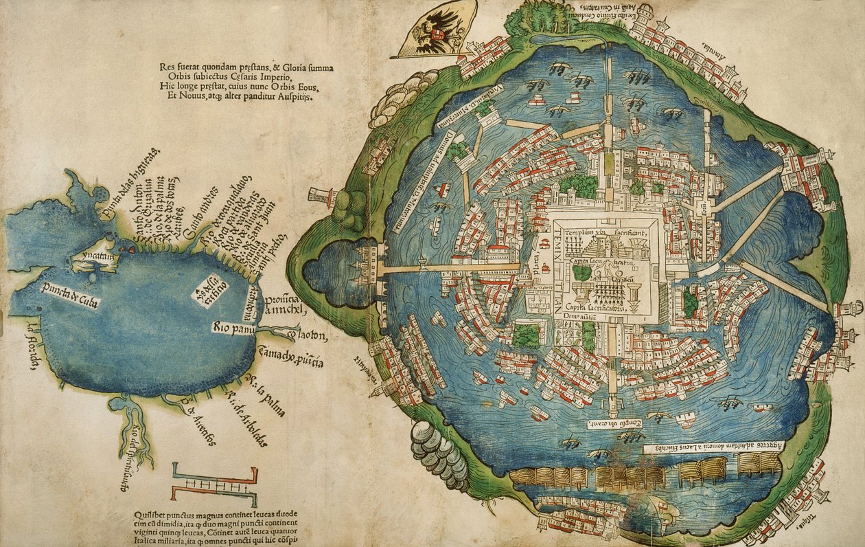
Map of Tenochtitlan and the Gulf of Mexico, from Praeclara Ferdinadi Cortesii de Nova maris Oceani Hyspania Narratio by Hernando Cortés (1485-1547), 1524 by Spanish School

Map of Tenochtitlan and the Gulf of Mexico, from Praeclara Ferdinadi Cortesii de Nova maris Oceani Hyspania Narratio by Hernando Cortés (1485-1547), 1524

(Map of Tenochtitlan and the Gulf of Mexico, from Praeclara Ferdinadi Cortesii de Nova maris Oceani Hyspania Narratio by Hernando Cortes (1485-1547) 1524 )


Spanish School

€ 124.18
Tax-free
   Configure art print
1524  ·  colour lithograph  ·  Image ID: 430851

Cultural Circles  ·  Cartography

Map of Tenochtitlan and the Gulf of Mexico, from Praeclara Ferdinadi Cortesii de Nova maris Oceani Hyspania Narratio by Hernando Cortés (1485-1547), 1524 by Spanish School. Available as an art print on canvas, photo paper, watercolor board, natural paper, or Japanese paper.
hernan · exploration · early · cartography · chart · city · town · aztec · capital · mexico city · island · conquistadors · Newberry Library, Chicago, Illinois, USA / Bridgeman Images
AR/3D   View in 3D / AR zu Favoriten hinzufügen   Add to favorites    Change wall color    View picture in a room
0 Reviews

Configure art print

Picture Frame

Medium & Stretcher

Glass & Passepartout

Miscellaneous & Extras

 Save / compare configuration
Preview Icon

Summary

Gemälde
Veredelung
Keilrahmen
Museumslizenz

€ 124.18
(inkl. 20% MwSt)
   Add to cart

Bildschärfe: PERFEKT

If you'd like us to adjust the brightness, colors, or crop the image, we're happy to do this for you at no extra cost. Just get in touch!

Similar artworks selected for you

Plan of Mexico, in Hernando Cortés, La Preclara Narratione di Ferdinando Cortese della Nuova Hispagna, Venice Map of Tenochtitlan from „Praeclara Ferdinandi Cortesii de Nova Maris Oceani Hispania Narrati“ Plan of Constantinople Algiers, Algeria Algiers, Algeria View of Algiers, Algeria Map of Algiers - Algeria (engraving) Island, Khalkis, Dalmatia Siege of Malta (detail) Map of Jerusalem and the Surrounding Area, from Map of Algiers from Zwolle, Netherlands - in Map of Tunis, Tunisia, from Civitates Orbis Terrarum, engraving Map of Messina, from Venice, Italy Map of Jerusalem and the Surrounding Area, from Zwolle, Netherlands (engraving) Plan of Venice, Italy Circular Map of Vienna during the Turkish siege City of Quinsai (now Tianjin), engraving from La Cosmographie Universelle (Universal Cosmography) by André Thevet Enkhuizen, Netherlands - in Map of Toledo, from Civitates Orbis Terrarum by Georg Braun (1541-1622) and Frans Hogenberg (1535-90), 1566 Enkhuizen, Netherlands (engraving) Chart of Algiers Bay Brielle, Netherlands Messina, Italy Flemish, Belgium - in Map of Messina, Italy A View of Venice
Show more similar artworks

Similar artworks selected for you

Plan of Mexico, in Hernando Cortés, La Preclara Narratione di Ferdinando Cortese della Nuova Hispagna, Venice Map of Tenochtitlan from „Praeclara Ferdinandi Cortesii de Nova Maris Oceani Hispania Narrati“ Plan of Constantinople Algiers, Algeria Algiers, Algeria View of Algiers, Algeria Map of Algiers - Algeria (engraving) Island, Khalkis, Dalmatia Siege of Malta (detail) Map of Jerusalem and the Surrounding Area, from Map of Algiers from Zwolle, Netherlands - in Map of Tunis, Tunisia, from Civitates Orbis Terrarum, engraving Map of Messina, from Venice, Italy Map of Jerusalem and the Surrounding Area, from Zwolle, Netherlands (engraving) Plan of Venice, Italy Circular Map of Vienna during the Turkish siege City of Quinsai (now Tianjin), engraving from La Cosmographie Universelle (Universal Cosmography) by André Thevet Enkhuizen, Netherlands - in Map of Toledo, from Civitates Orbis Terrarum by Georg Braun (1541-1622) and Frans Hogenberg (1535-90), 1566 Enkhuizen, Netherlands (engraving) Chart of Algiers Bay Brielle, Netherlands Messina, Italy Flemish, Belgium - in Map of Messina, Italy A View of Venice
Show more similar artworks

More art prints by Spanish School

Christ of Burgos, in the Chapel of the Most Holy Christ The hand of God, detail of a fresco by the Master of Sant Climent de Taüll Map of Tenochtitlan and the Gulf of Mexico, from Praeclara Ferdinadi Cortesii de Nova maris Oceani Hyspania Narratio by Hernando Cortés (1485-1547), 1524 One of two pink Qur Fol. 61v Game of pelota in the open air, from the manuscript made under the direction of Alfonso X (1221-84) the Wise, King of Castile and León Angels and David with the Ark of the Covenant standing before the Temple of Solomon, fol. 139r., from the Visigothic-Mozarabic Bible of St. Isidore, A.D. 960 Complutensian Polyglot Bible, printed by Arnao Guillen de Brocar Genealogy of the Inca rulers and their Spanish successors from Manco Capac, the first Inca king, to Ferdinand VI of Spain, c. 1750 Map showing the route of Christopher Columbus on his first voyage to the New World Map of the Island of Mallorca, 1785 Teresa of Ávila View of the Lower Gallery of the Monastery of San Juan de Los Reyes, Toledo Interior view of the ’Great Lyceum’ during a carnival before the fire which destroyed the theatre Charles V (1500-58) Map of Charles V, map by Mecia de Viladestes, a portolan of Europe and North Africa, 1413
Show more works by Spanish School

More art prints by Spanish School

Christ of Burgos, in the Chapel of the Most Holy Christ The hand of God, detail of a fresco by the Master of Sant Climent de Taüll Map of Tenochtitlan and the Gulf of Mexico, from Praeclara Ferdinadi Cortesii de Nova maris Oceani Hyspania Narratio by Hernando Cortés (1485-1547), 1524 One of two pink Qur Fol. 61v Game of pelota in the open air, from the manuscript made under the direction of Alfonso X (1221-84) the Wise, King of Castile and León Angels and David with the Ark of the Covenant standing before the Temple of Solomon, fol. 139r., from the Visigothic-Mozarabic Bible of St. Isidore, A.D. 960 Complutensian Polyglot Bible, printed by Arnao Guillen de Brocar Genealogy of the Inca rulers and their Spanish successors from Manco Capac, the first Inca king, to Ferdinand VI of Spain, c. 1750 Map showing the route of Christopher Columbus on his first voyage to the New World Map of the Island of Mallorca, 1785 Teresa of Ávila View of the Lower Gallery of the Monastery of San Juan de Los Reyes, Toledo Interior view of the ’Great Lyceum’ during a carnival before the fire which destroyed the theatre Charles V (1500-58) Map of Charles V, map by Mecia de Viladestes, a portolan of Europe and North Africa, 1413
Show more works by Spanish School

More motifs from the category Cartography

Double Hemisphere World Map, 1587 Map of Armenia, Colchis, Iberia and Albania, from Map of Sixteenth Century Europe, from the Italy and Sicily from a Renaissance map of Europe, Jacopo Russo (after), 1528 The New World, from an Atlas of the World in 33 Maps, Venice, 1st September 1553 Map of the Battle of Trafalgar, published by William Blackwood and Sons, Edinburgh and London, 1848 Ms 988 volume 3 fol. 33 Map of the town and citadel of Belle-Île, from the “Atlas Louis XIV”, 1683-88 Map of Naples, from ‘Civitates Orbis Terrarum’ by Georg Braun (1541-1622) and Frans Hogenberg (1535-90), c.1572 Map of Africa Map of Sussex, 26th March 1805 Ms. 988, Vol.3 fol.10 Map of Saint-Quentin, from the ’Atlas Louis XIV’, 1683-88 Map of the Americas, published by Homann, 1746 Map of the Caribbean Islands Map of Europe, 1841 Map of Canada, from
View More from "Cartography"

More motifs from the category Cartography

Double Hemisphere World Map, 1587 Map of Armenia, Colchis, Iberia and Albania, from Map of Sixteenth Century Europe, from the Italy and Sicily from a Renaissance map of Europe, Jacopo Russo (after), 1528 The New World, from an Atlas of the World in 33 Maps, Venice, 1st September 1553 Map of the Battle of Trafalgar, published by William Blackwood and Sons, Edinburgh and London, 1848 Ms 988 volume 3 fol. 33 Map of the town and citadel of Belle-Île, from the “Atlas Louis XIV”, 1683-88 Map of Naples, from ‘Civitates Orbis Terrarum’ by Georg Braun (1541-1622) and Frans Hogenberg (1535-90), c.1572 Map of Africa Map of Sussex, 26th March 1805 Ms. 988, Vol.3 fol.10 Map of Saint-Quentin, from the ’Atlas Louis XIV’, 1683-88 Map of the Americas, published by Homann, 1746 Map of the Caribbean Islands Map of Europe, 1841 Map of Canada, from
View More from "Cartography"

A selection of our top sellers

The garden of the magician Klingsor, from the Parzival cycle, Great Music Room, c. 1883-84 Bauhaus Stairway, 1932 Circe, c. 1889 The Quarrel of Oberon and Titania The Garden of Earthly Delights Sunny Day in the Countryside The Scarlet Sunset The Water Lily Pond in the Evening Aerial Life Woman at Dawn Cubist Lilies The Night Watch Bear in Snow, 1940 Monk by the Sea Water Serpents II
Show more artworks

A selection of our top sellers

The garden of the magician Klingsor, from the Parzival cycle, Great Music Room, c. 1883-84 Bauhaus Stairway, 1932 Circe, c. 1889 The Quarrel of Oberon and Titania The Garden of Earthly Delights Sunny Day in the Countryside The Scarlet Sunset The Water Lily Pond in the Evening Aerial Life Woman at Dawn Cubist Lilies The Night Watch Bear in Snow, 1940 Monk by the Sea Water Serpents II
Show more artworks


What our customers think about us


Frequently Asked Questions about Meisterdrucke


Personalizing your art print at Meisterdrucke is simple and intuitive: Choose a frame, set the image size, pick a printing medium, and add suitable glazing or a stretcher frame. We also offer additional customization options like mats, fillets, and spacers. If you have any questions, our customer service team is ready to help you create your perfect artwork.

At Meisterdrucke, you can visualize your configured artwork directly in your own room. Simply upload a photo of your space and see how the artwork looks in it. If you're visiting us on a mobile device — phone or tablet — our augmented reality feature brings the picture to life and projects it right into your room. A unique experience that combines art and technology.

Choosing the right medium is often a matter of personal taste. To give you a better idea, we've provided some images for each medium. We also offer a sample set of all paper variants, so you can decide not just visually but by touch as well. You can order the sample set free of charge — only shipping costs apply.

Don't worry! At Meisterdrucke, we don't just process orders mechanically. Every order is manually reviewed by our team. If we spot any inconsistencies or issues with your configuration, we'll get in touch with you right away. And of course, our friendly and patient support team is always here to help you with your configuration. We'll work with you by phone or email to adjust your image so the final result is exactly what you had in mind.


Still have questions?

Are you interested in an art print from our manufactory but still unsure? Do you need advice on choosing the medium or help with the order?

Our experts are happy to assist you.

+43 4257 29415
support@meisterdrucke.com
Mo-Do: 7:00 - 16:00 | Fr: 7:00 - 13:00

Still have questions?

Are you interested in an art print from our manufactory but still unsure? Do you need advice on choosing the medium or help with the order?

Our experts are happy to assist you.

+43 4257 29415
support@meisterdrucke.com
Mo-Do: 7:00 - 16:00 | Fr: 7:00 - 13:00


Meisterdrucke

   Kärntner Strasse 46
        9586 Finkenstein am Faaker See
        Austria
        +43 4257 29415
        support@meisterdrucke.com
Other languages

                   
Erfahrungen & Bewertungen zu Meisterdrucke
Post.at DHL Express Quehenberger Cargoboard
Kaiser Franz Joseph

Meisterdrucke
Kärntner Strasse 46
9586 Finkenstein am Faaker See · Austria
+43 4257 29415 · support@meisterdrucke.com
Post.at DHL Express Quehenberger Cargoboard


(c) 2026 meisterdrucke.uk