support@meisterdrucke.com  ·  0043 4257 29415

Deutsch English Italiano Español Français Nederlands Português Svenska Polski Dansk
Search by artist, work title or style – e.g. Monet, Starry Night, Impressionism, Hokusai wave, nude. Describe the scene – e.g. green meadow, abstract with lots of red, dark oil painting, standing nude next to a tree.

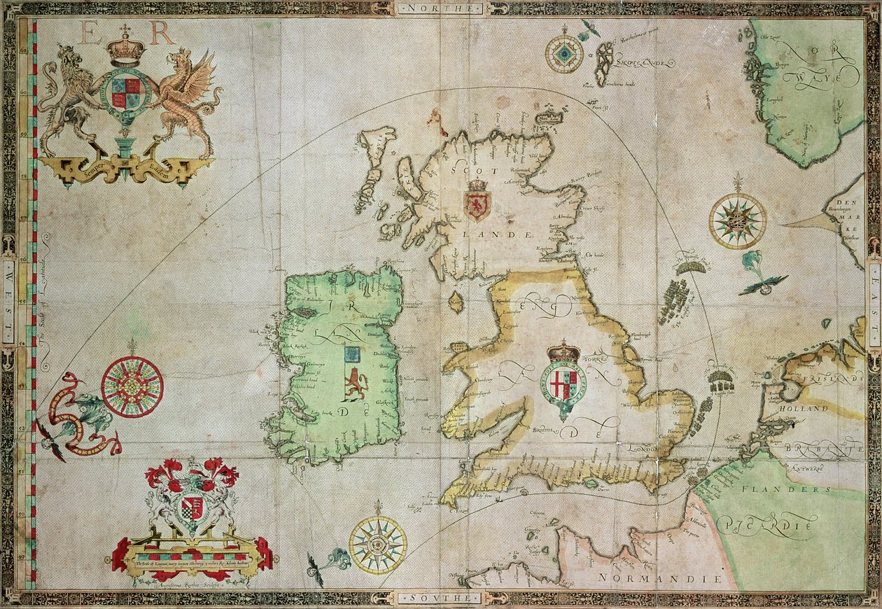
Map showing the route of the Armada fleet, engraved by Augustine Ryther, 1588 by Robert Adams

Map showing the route of the Armada fleet, engraved by Augustine Ryther, 1588

(Map showing the route of the Armada fleet, engraved by Augustine Ryther, 1588 (see 133339 for bw))


Robert Adams

€ 133.83
Tax-free
   Configure art print
1588  ·  engraving  ·  Image ID: 53272

Nonclassified artists  ·  Cartography

Map showing the route of the Armada fleet, engraved by Augustine Ryther, 1588 by Robert Adams. Available as an art print on canvas, photo paper, watercolor board, natural paper, or Japanese paper.
spanish · ship · attacking · coat of arms · sir francis drake · great britain · ireland · ships · navy · scotland · northern europe · compass · Private Collection / Bridgeman Images
Other color versions of this image  
AR/3D   View in 3D / AR zu Favoriten hinzufügen   Add to favorites    Change wall color    View picture in a room
0 Reviews

Configure art print

Picture Frame

Medium & Stretcher

Glass & Passepartout

Miscellaneous & Extras

 Save / compare configuration
Preview Icon

Summary

Gemälde
Veredelung
Keilrahmen
Museumslizenz

€ 133.83
(inkl. 20% MwSt)
   Add to cart

Bildschärfe: PERFEKT

If you'd like us to adjust the brightness, colors, or crop the image, we're happy to do this for you at no extra cost. Just get in touch!

Similar artworks selected for you

Map of the Kingdom of Great Britain and Ireland, 1610 A Generall Carde, and Description of the Sea Coasts of Europe, and Navigation in This Book Conteyned England, Scotland and Ireland Map of Britain, 1631 The Invasions of England and Ireland with All Their Civil Wars Since the Conquest, c.1627 Britain As It Was Divided In The Time of the English Saxons especially during their Heptarchy Britain As It Was Divided In The Time of the English Saxons, 1616 Great Britain and Ireland from Theatrum Orbis Terrarum by Willem Bleau, Amsterdam Atlantic Coasts of Europe, Norway to Finisterre England British Islands: England, Scotland, and Ireland Map depicting the Invasions of England and Ireland with all their Civil Wars since the Conquest, c. 1627 The British Isles, Iberia and Northwest Africa, detail from a world atlas, 1565 Anglia: England and Wales. 1579 Map showing the route of the Armada fleet, engraved by Augustine Ryther, 1588 Great Britain, in Ireland and Great Britain, in The Kingdom of England (engraved by Jodocus Hondius) Map of England and Ireland drawn in 1606 (coloured engraving) Anglia: England and Wales The Kingdom of Scotland, Engraved by Jodocus Hondius from Great Britain and Ireland Portolan Chart of Western Europe and North Africa The battle off the Isle of Wight on 4 August Portolan Chart of Western Europe and North Africa Map of England, Scotland and Ireland (Great Britain) New map of the most flourishing kingdom of England, by Humphrey Lloyd of Denbigh
Show more similar artworks

More art prints by Robert Adams

Map No. 8 showing the route of the Armada fleet, engraved by Augustine Ryther, 1588 Map No. 5 Showing the route of the Armada fleet, engraved by Augustine Ryther, 1588 Map No.2 Showing the route of the Armada fleet, engraved by Augustine Ryther, 1588 Map No.9 showing the route of the Armada fleet, engraved by Augustine Ryther, 1588 Map No.4 Showing the Route of the Armada Fleet, Engraved by Augustine Ryther Map showing the route of the Armada fleet, engraved by Augustine Ryther, 1588 Map showing the route of the Armada fleet, engraved by Augustine Ryther, 1588 Map No.7 Showing the Route of the Armada Fleet, Engraved by Augustine Ryther, 1588 Map No. 1 Showing the Route of the Armada Fleet, Engraved by Augustine Ryther Map No.6 showing the route of the Armada fleet, engraved by Augustine Ryther, 1588 Map Showing the route of the Armada fleet, engraved by Augustine Ryther Map No.10 showing the route of the Armada fleet, engraved by Augustine Ryther
Show more works by Robert Adams

More motifs from the category Cartography

Map of Eastern North America: Florida to Chesapeake Bay Map of Animals in Africa Sf Renaissance map of Europe, after Jacopo Russo, 1528 Partial Map of Middle East in the 1890s, from “The Citizen Map of France, c.1830-40 Map of Europe after the Peace of Tilsit in 1807, from Map of Berlin, printed by the Royal Lithographic Institute, Berlin, 1857 Map of the dominions of the Angevins, c. 1170, from Map of the Southern Sky, with representations of constellations, decorated with the crest of Cardinal Lang von Wellenburg, and a dedication to him with his coats of arms and the Imperial copyright, 15 Map of the County of Philadelphia from Actual Survey, 1843 Map of Greece, Hungary and their surrounding countries Map of La Rochelle, from Map of Alexander the Great Map of Spain and Portugal showing the political divisions in the country at the death of Alfonso III, King of Leon, from Map of the Coast of New England, Observed and Described by Captain John Smith (1580-1631) 1614, from
View More from "Cartography"

A selection of our top sellers

Ice Floes at Bennecourt Map of the Battle of Trafalgar, published by William Blackwood and Sons, Edinburgh and London, 1848 Midsummer Eve Bridge in Monet Wheatfield Dance at Le Moulin de la Galette Roller-Skating Club Around Alexanderplatz Summer Evening on the Skagen Southern Beach with Anna Ancher and Marie Krøyer Monkey in a Persimmon Tree, 1935 The Greifswald Market Lake Thun with the Niesen Stage set for the Queen of the Night (in Mozart Reduced Weight The Harvest Head Study of a Lioness
Show more artworks


What our customers think about us


Frequently Asked Questions about Meisterdrucke


Personalizing your art print at Meisterdrucke is simple and intuitive: Choose a frame, set the image size, pick a printing medium, and add suitable glazing or a stretcher frame. We also offer additional customization options like mats, fillets, and spacers. If you have any questions, our customer service team is ready to help you create your perfect artwork.

At Meisterdrucke, you can visualize your configured artwork directly in your own room. Simply upload a photo of your space and see how the artwork looks in it. If you're visiting us on a mobile device — phone or tablet — our augmented reality feature brings the picture to life and projects it right into your room. A unique experience that combines art and technology.

Choosing the right medium is often a matter of personal taste. To give you a better idea, we've provided some images for each medium. We also offer a sample set of all paper variants, so you can decide not just visually but by touch as well. You can order the sample set free of charge — only shipping costs apply.

Don't worry! At Meisterdrucke, we don't just process orders mechanically. Every order is manually reviewed by our team. If we spot any inconsistencies or issues with your configuration, we'll get in touch with you right away. And of course, our friendly and patient support team is always here to help you with your configuration. We'll work with you by phone or email to adjust your image so the final result is exactly what you had in mind.


Still have questions?

Are you interested in an art print from our manufactory but still unsure? Do you need advice on choosing the medium or help with the order?

Our experts are happy to assist you.

+43 4257 29415
support@meisterdrucke.com
Mo-Do: 7:00 - 16:00 | Fr: 7:00 - 13:00

Still have questions?

Are you interested in an art print from our manufactory but still unsure? Do you need advice on choosing the medium or help with the order?

Our experts are happy to assist you.

+43 4257 29415
support@meisterdrucke.com
Mo-Do: 7:00 - 16:00 | Fr: 7:00 - 13:00


Meisterdrucke

   Kärntner Strasse 46
        9586 Finkenstein am Faaker See
        Austria
        +43 4257 29415
        support@meisterdrucke.com
Other languages

                   
Erfahrungen & Bewertungen zu Meisterdrucke
Post.at DHL Express Quehenberger Cargoboard
Kaiser Franz Joseph

Meisterdrucke
Kärntner Strasse 46
9586 Finkenstein am Faaker See · Austria
+43 4257 29415 · support@meisterdrucke.com
Post.at DHL Express Quehenberger Cargoboard


(c) 2026 meisterdrucke.uk