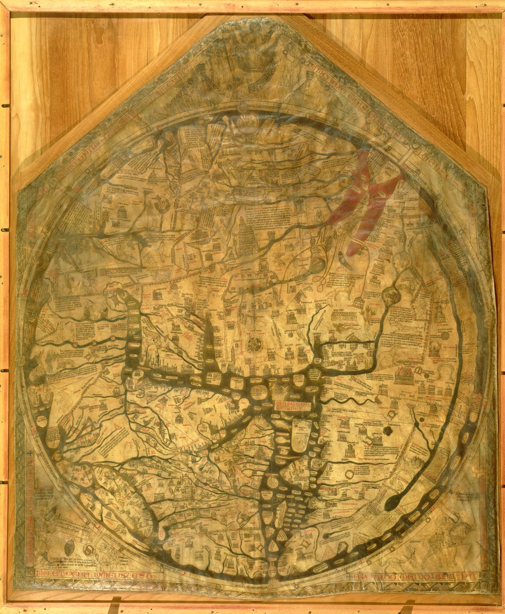
Mappa Mundi, c.1290 by Richard of Haldingham

Mappa Mundi, c.1290

(Mappa Mundi, c.1290 )


Richard of Haldingham

€ 110.72
Enthält 0% MwSt.
   Configure art print
1290  ·  vellum  ·  Picture ID: 97314

Nonclassified artists  ·  Cartography

Mappa Mundi, c.1290 by Richard of Haldingham. Available as an art print on canvas, photo paper, watercolor board, uncoated paper or Japanese paper.
world map · medieval · golden fleece · griffon · hyrcanean tiger · manticora · caspian gates · bactrian camel · bethlehem · rhodes · colossus · mermaid · mount of olives · mount calvary · salamander · river nile · sodom · gomorrah · jordan · unicorn · bear · severn · tweed · labyrinth · maze · crucifixion · Hereford Cathedral, Herefordshire, UK / Bridgeman Images
zu Favoriten hinzufügen   Add to favorites    Select wall color    View painting in a room AR/3D   View in 3D / AR

Note: Only reviews with comments are displayed. Reviews can be submitted directly after purchase in your customer account.

Configure art print

Picture Frame

Medium & Stretcher

Glass & Passepartout

Miscellaneous & Extras

 Save / compare configuration
Preview Icon

Summary

Gemälde
Veredelung
Keilrahmen
Museumslizenz

€ 110.72
(inkl. 20% MwSt)
   Add to cart

Bildschärfe: PERFEKT

Should you desire adjustments to brightness and color, or a custom crop of the motif, we are happy to make these changes at no additional cost to you. Please do not hesitate to contact us.

Similar artworks selected for you

Hereford Mappa Mundi Map of the Mantuan territory, carved in low relief The Mappa Mundi of Fra Mauro, a Camaldolese Monk from the Monastery of San Michele in Murano The Hereford Mappa Mundi Detail of the Mediterranean from the Mappa Mundi, c.1290 Map of Peru by Egnazio Danti, Mathematician, Cosmographer and Italian Architect. Around 1567. Florence, Palazzo Vecchio, Sala del Mappamondo Map of Mexico Map of Mediterranean Sea Plan of Rome Fra Mauro map World map of Paolo Toscanelli. 1457. This map represents the European image of the Earth before the discovery of the great continents. Library Nazionale Florence Armenia Map of the World, from Polychronicon Map of the World Moscow Region Map by Egnazio Danti Map of the World with Jerusalem as the Centre, Polychronicon, c.1380 Livonia on the Baltic Sea, and Lithuania Map by Egnazio Danti (1536-1586) Mathematician, Cosmographer and Italian Architect. Around 1567. Florence, Palazzo Vecchio, Sala del Mappamondo Geographic map of Gauls showing the borders with Germany and Italy. Realised by cartographer Jean Jolivet (16th century) Map of Mexico and Central America Geographic Map of the World Map of Armenia World Chart, from Eastern Coasts of America to India Map of the Castellany of Bruges Rectangular map of the World, c.1030 Charts 2v and 3r of the Mediceo Atlas (Gaddi 9) Veneto territory between Brenta and Piave (map) Gotha During the Siege of Grimmenstein Map of Africa, after an original of 1447 Russia Moscovia
Show more similar artworks

Other motives from the category Cartography

The Holy Land, from an Atlas of the World in 33 Maps, Venice Map of Southern Italy, Corsica, and Sardinia Known in Ancient Times as Great Greece or Magnia Graecia Map of the route followed by Hernando Cortes during the conquest of Mexico World map, illustration from Atlas Geographique Moderne by Prosper-Auguste Poulain de Bossay, c.1850 The South Pole, (detail) from the Map No. 1 Showing the Route of the Armada Fleet, Engraved by Augustine Ryther The Sea of Galilee, from an Atlas of the World in 33 Maps (detail) Plan and map of the town and citadel of Mont-Louis Map of Mexico or New Spain, 1625 A Map of Tyburn, 1746 (detail) Map of Europe, from a Facsimile of the Map of the Battle of Talavera, Published by William Blackwood and Sons, Edinburgh and London, 1848 The Pacific Ocean, from an Atlas of the World in 33 Maps, Venice, 1st September 1553 A map of the model of Roman London on exhibition in the Undercroft of All-Hallows-by-the-Tower Falkland Islands and Patagonia, from a Series of World Maps published by John Tallis and Co., New York and London, 1850s
View More from "Cartography"

Excerpt from our top sellers

Battle of Waterloo, 18th June 1815 Heath Princess The Zaporozhye Cossacks Writing a Letter to the Turkish Sultan Four Foxes Ascending Path Moon rising Over the Sea Wheatfield Under Thunderclouds The Boxer A Young Girl Defending Herself against Eros Luncheon of the Boating Party The Creation of the World Representing the Cosmic Sphere of the Earth (Back Panels of the Triptych Sunset on the Seine at Lavacourt, Winter Effect The Monk by the Sea, 1808-1810 The Incredulity of St. Thomas, 1602-03 The Kiss
Show More Artworks


What our customers think about us


Frequently Asked Questions about Meisterdrucke


Personalizing your art print at Meisterdrucke is a simple and intuitive process that allows you to design an artwork exactly to your specifications: Choose a frame, determine the image size, decide on a printing medium, and add suitable glazing or a stretcher frame. We also offer customization options such as mats, fillets, and spacers. Our customer service is available to help you design your perfect artwork.

At Meisterdrucke, you have the fascinating option to visualize the artwork you configured directly in your own space. For a tailored preview, simply upload a photo of your room and let the artwork appear on it. If you visit us via a mobile device, be it a phone or tablet, our augmented reality feature brings the image to life and seamlessly projects it into your space. An experience that uniquely combines art and technology.

Choosing the medium is often a matter of personal taste. To give you a clearer idea, we have provided some images for each medium. For a holistic experience, we also offer you a sample set of all paper variants so you can make a decision not just visually but also haptically. You can take advantage of the sample set free of charge – only the shipping costs will apply. You can order the sample set directly.

Do not worry. At Meisterdrucke, we do not proceed mechanically. We manually review each order. If there are any inconsistencies or peculiarities in the configuration, we will immediately contact you. Of course, our courteous and patient support is always at your side to assist you with the configuration. Together with you, we adjust your image by phone or email so that the final result exactly meets your expectations.


Do you have any questions?

Are you interested in an art print from our manufactory but still unsure? Do you need advice on choosing the medium or help with the order?

Our experts are happy to assist you.

+43 4257 29415
support@meisterdrucke.com
Mo-Do: 7:00 - 16:00 | Fr: 7:00 - 13:00

Do you have any questions?

Are you interested in an art print from our manufactory but still unsure? Do you need advice on choosing the medium or help with the order?

Our experts are happy to assist you.

+43 4257 29415
support@meisterdrucke.com
Mo-Do: 7:00 - 16:00 | Fr: 7:00 - 13:00


Meisterdrucke

   Kärntner Strasse 46
        9586 Finkenstein am Faaker See
        Austria
        +43 4257 29415
        support@meisterdrucke.com
Other languages

                   
Erfahrungen & Bewertungen zu Meisterdrucke
Partner Logos

Kaiser Franz Joseph

Meisterdrucke
Kärntner Strasse 46
9586 Finkenstein am Faaker See · Austria
+43 4257 29415 · office@meisterdrucke.com
Partner Logos


(c) 2025 meisterdrucke.uk