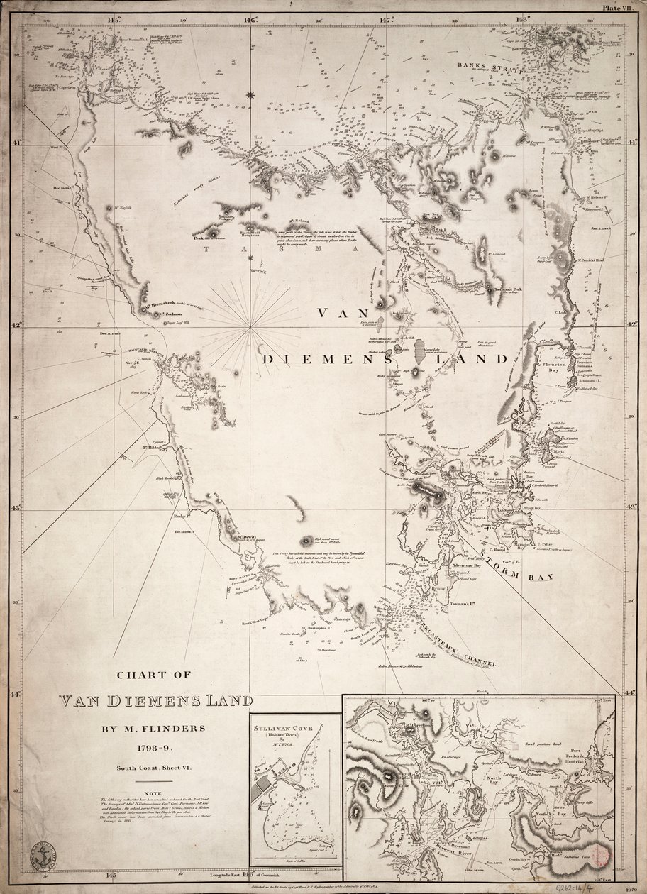
Chart of Van Diemens Land, sheet VI by Matthew Flinders

Chart of Van Diemens Land, sheet VI


Matthew Flinders

€ 119.98
Enthält 0% MwSt.
   Configure art print
Undated  ·  engraving  ·  Picture ID: 1507732

Nonclassified artists

Chart of Van Diemens Land, sheet VI by Matthew Flinders. Available as an art print on canvas, photo paper, watercolor board, uncoated paper or Japanese paper.
19th century · australia · oceania · cartography · engraving · black and white · mzengraving · · National Maritime Museum, London, UK / Bridgeman Images
AR/3D   View in 3D / AR zu Favoriten hinzufügen   Add to favorites    Select wall color    View painting in a room
0 Reviews

Configure art print

Picture Frame

Medium & Stretcher

Glass & Passepartout

Miscellaneous & Extras

 Save / compare configuration
Preview Icon

Summary

Gemälde
Veredelung
Keilrahmen
Museumslizenz

€ 119.98
(inkl. 20% MwSt)
   Add to cart

Bildschärfe: PERFEKT

Should you desire adjustments to brightness and color, or a custom crop of the motif, we are happy to make these changes at no additional cost to you. Please do not hesitate to contact us.

Similar artworks selected for you

A chart of Basses Straight between New South Wales and Van Diemans Land surveyed by Lieut. Flinders of HMS Plan of the Harbour of the Seychelles A Chart of the Harbour of Rhode Island and Narraganset Bay Chart of the Gulf of Finland and Baltic Sea Map of the United States, 1816 Chart of Bass Strait by Matthew Flinders Chart of the Promontory of Boodroom with the Karabaghla Islands and the North Point of the Island of Kos ... by Francis Beaufort F.R.S. ... 1811 Plymouth Bay Plan of the harbour of Praslin, late 18th to early 19th century The south-eastern part of Tierra del Fuego with Staten Island, Cape Horn and Diego Ramirez Island Chart showing discoveries of Ross, Parry and Franklin in the Arctic during 1818-1827 A Chart Showing Part of the Coast of North-West America Map of Chile, Patagonia, Tierra del Fuego and the Falkland Islands, c.1798 Franz Josef Land, 1899 Bay of Navarino West coast of Africa Spanish Map of Florida and the Bahamas, 1805 Plan of the Harbour, Fort, Town and Environs of Fort Royal in Martinique General Map Covering North Pacific Ocean and Adjacent Coastal Regions Map of Sea Discoveries by Russian Navigators in the Pacific and Arctic Oceans - Made in Various Years Bombay Map of Jemtland (1831) Egypt and Nubia, Volume III: Map to Illustrate the Sketches of David Roberts, Esq: R.A. in Egypt and Nubia 1849 Chart of New Zealand, explored in 1769 and 1770 by Lieutenant J. Cook West Coast of Africa, from Lisbon to Sierra Leone, from Chart of South America and the Atlantic Coast Chart of the search for Sir John Franklin and discovery of the North West Passage Map of the South China Sea, from the itinerary of La Perouse Conjectural Map of Atlantis
Show more similar artworks

Other art prints by Matthew Flinders

Chart of Van Diemens Land, sheet VI Map of Australia Chart of Terra Australis (Australia) Roughly Sketched Chart of A chart of Basses Straight between New South Wales and Van Diemans Land surveyed by Lieut. Flinders of HMS Chart of Terra Australis, South Coast, Sheet III Facsimile copy of a letter to Sir Joseph Banks from Captain Matthew Flinders, dated March 1806, from The History of Australian Exploration from 1788-1888, 1888 Chart of Bass Strait by Matthew Flinders
Discover more works by Matthew Flinders

Excerpt from our top sellers

The Buddha The Apple Tree Cotopaxi Waterlilies, Evening Hunters in the Snow The Ice Sea Some New Year Customs in Galloway The Olive Trees Poster advertising the Hamburg-Amerika Line Seascape near Les Saintes-Maries-de-la-Mer Supper at Emmaus The Disciples Peter and John Running to the Sepulchre on the Morning of the Resurrection Painting from the Tomb of the Diver from the Southern Cemetery at Paestum, 480-470 BC The Red Pines View of the Dents-du-Midi from Champéry
Show More Artworks


What our customers think about us


Frequently Asked Questions about Meisterdrucke


Personalizing your art print at Meisterdrucke is a simple and intuitive process that allows you to design an artwork exactly to your specifications: Choose a frame, determine the image size, decide on a printing medium, and add suitable glazing or a stretcher frame. We also offer customization options such as mats, fillets, and spacers. Our customer service is available to help you design your perfect artwork.

At Meisterdrucke, you have the fascinating option to visualize the artwork you configured directly in your own space. For a tailored preview, simply upload a photo of your room and let the artwork appear on it. If you visit us via a mobile device, be it a phone or tablet, our augmented reality feature brings the image to life and seamlessly projects it into your space. An experience that uniquely combines art and technology.

Choosing the medium is often a matter of personal taste. To give you a clearer idea, we have provided some images for each medium. For a holistic experience, we also offer you a sample set of all paper variants so you can make a decision not just visually but also haptically. You can take advantage of the sample set free of charge – only the shipping costs will apply. You can order the sample set directly.

Do not worry. At Meisterdrucke, we do not proceed mechanically. We manually review each order. If there are any inconsistencies or peculiarities in the configuration, we will immediately contact you. Of course, our courteous and patient support is always at your side to assist you with the configuration. Together with you, we adjust your image by phone or email so that the final result exactly meets your expectations.


Do you have any questions?

Are you interested in an art print from our manufactory but still unsure? Do you need advice on choosing the medium or help with the order?

Our experts are happy to assist you.

+43 4257 29415
support@meisterdrucke.com
Mo-Do: 7:00 - 16:00 | Fr: 7:00 - 13:00

Do you have any questions?

Are you interested in an art print from our manufactory but still unsure? Do you need advice on choosing the medium or help with the order?

Our experts are happy to assist you.

+43 4257 29415
support@meisterdrucke.com
Mo-Do: 7:00 - 16:00 | Fr: 7:00 - 13:00


Meisterdrucke

   Kärntner Strasse 46
        9586 Finkenstein am Faaker See
        Austria
        +43 4257 29415
        support@meisterdrucke.com
Other languages

                   
Erfahrungen & Bewertungen zu Meisterdrucke
Post.at DHL Express Quehenberger Cargoboard
Kaiser Franz Joseph

Meisterdrucke
Kärntner Strasse 46
9586 Finkenstein am Faaker See · Austria
+43 4257 29415 · office@meisterdrucke.com
Post.at DHL Express Quehenberger Cargoboard


Meisterdrucke 2707 Bewertungen auf ProvenExpert.com

(c) 2025 meisterdrucke.uk