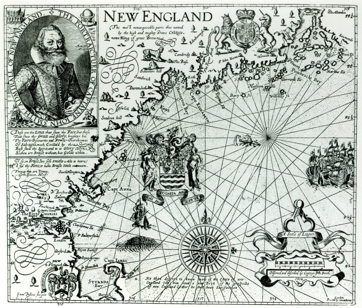
Map of the New England coastline in 1614, engraved by Simon de Passe by John Smith 2

Map of the New England coastline in 1614, engraved by Simon de Passe

(Map of the New England coastline in 1614, engraved by Simon de Passe (1595-1647) 1616 )


John Smith 2

€ 107.9
Enthält 0% MwSt.
   Configure art print
Undated  ·  Gravur  ·  Picture ID: 115417

Nonclassified artists  ·  Cartography

Map of the New England coastline in 1614, engraved by Simon de Passe by John Smith 2. Available as an art print on canvas, photo paper, watercolor board, uncoated paper or Japanese paper.
plan · cartouche · portrait · aged 37 · compass · charles river · boston · new hampshire · royal coat of arms · Private Collection / Bridgeman Images
Other color variations of this picture  
AR/3D   View in 3D / AR zu Favoriten hinzufügen   Add to favorites    Select wall color    View painting in a room
0 Reviews

Configure art print

Picture Frame

Medium & Stretcher

Glass & Passepartout

Miscellaneous & Extras

 Save / compare configuration
Preview Icon

Summary

Gemälde
Veredelung
Keilrahmen
Museumslizenz

€ 107.9
(inkl. 20% MwSt)
   Add to cart

Bildschärfe: PERFEKT

Should you desire adjustments to brightness and color, or a custom crop of the motif, we are happy to make these changes at no additional cost to you. Please do not hesitate to contact us.

Similar artworks selected for you

Portrait of Captain John Smith. A picture of the coast of New England, in Part of Captain John Smith Part of Captain J Smith Map of the Coast of Norway and Sweden Between Merdøy and Uddevalla Map of the Coast of Norway and Sweden between Merdøy and Uddevalla Map of the Lands Around the Arctic Circle with the Three Voyages of the Dutch, 1598 Hydrographic Map of the Persian Gulf Map of the newly discovered Nova Zembla, illustration from Diarium Nauticum, seu vera descriptio trium navigationum admirandarum... by Gerrit de Veer Map of the Countries Around the Arctic Circle with the Three Voyages of the Dutch in 1598 Map of Willem Barentsz Third Voyage, 1598 A detail of two old-fashioned whale-like sea monsters and an inset with more lifelike whales, from Map of Maritime Greenland, Iceland, Davis Strait, Jan Mayen Island, and the Northern Coasts of Scotland and Ireland A New Map of the Sea Coasts of England, France and Holland Map of polar regions, by Dutch cartographer Willem Janszoon Blaeu New and Accurate Map of the Lands and Kingdoms of California, New Spain, Mexico, and Peru Pas-caert van de Canael, Tusschen Engelandt en Vranckryck, van Pleymuyen tot an de Sorlinges, als mede van Portbimel tot aen Heyssant Linschoten Map of England A chart of the sea coasts of new England, New Jersey, Virginia, Maryland and Carolina from Cape Cod to Cape Hatteras The South Pole, (detail) from the A Map of the Americas Pontus Euxinus or New and Accurate Sea Chart of the Black Sea from Various Sources Map Part of the Coast of Norway and Sweden Map of Part of the Coast of Norway and Sweden Map of New France dedicated to Colbert by Duchesneau, Intendant, 1681 A chart of the sea coasts of New England, New Jersey, Virginia, Maryland and Carolina from Cape Cod to Cape Hatteras
Show more similar artworks

Other art prints by John Smith 2

Map of the New England coastline in 1614, engraved by Simon de Passe Susquehannock Warrior (detail) Map of Virginia, discovered and described by Captain John Smith, 1606, engraved by William Hole, published 1612 Sunderland Harbour, 1883 Landscape, c1750 Frances, Duchess of Richmond (1578-1639) from Generall Historie of Virginia, 1624 General Grant and His Family Rhododendron × russelianum Low Quay, Sunderland The Second Oriental Head reverse copy Charles XII, King of Sweden Sir John Percivale Alexander Pope Portrait of Grinling Gibbons The General Historie of Virginia, New-England, and the Summer Isles, 1624
Discover more works by John Smith 2

Other motives from the category Cartography

Map of Florida, Canada and Labrador (from Map Depicting The Invasions of England and Ireland With All Their Civil Wars Since the Conquest, c.1627 Map of Israel, from Map of Mongolia showing Japan and China, c.1680 by Frederick de Wit Map of the Battle of Pultusk, Published by William Blackwood and Sons, Edinburgh and London Map of Le Marais, Paris Map of London, from Plan and map of the town and citadel of Mont-Louis Map of the Old and New Worlds, c.1500 Map of Florida, from Map of Lower Egypt and part of Syria, published by William Blackwood and Sons Map of Europe, Published in 1700, Paris Map of South America, published in 1700, Paris Map of the Battle of Dresden, published by William Blackwood and Sons, Edinburgh and London, 1848 Map of the Siege of the Castle of Burgos, Published by William Blackwood and Sons, Edinburgh and London
View More from "Cartography"

Excerpt from our top sellers

The Savage State from The Course of Empire The Destruction of Herculaneum and Pompeii The Dream Pine Forest (Left Panel) Childhood Friends Reclining Nude Circe Offering the Cup to Ulysses, 1891 Summer Night by the Beach The Dream of the Fisherman Night: A Port in the Moonlight, 1748 The Isle of the Dead Moonrise Satan Viewing the Ascent to Heaven Terrace of the Café on the Place du Forum in Arles in the Evening Appian Way
Show More Artworks


What our customers think about us


Frequently Asked Questions about Meisterdrucke


Personalizing your art print at Meisterdrucke is a simple and intuitive process that allows you to design an artwork exactly to your specifications: Choose a frame, determine the image size, decide on a printing medium, and add suitable glazing or a stretcher frame. We also offer customization options such as mats, fillets, and spacers. Our customer service is available to help you design your perfect artwork.

At Meisterdrucke, you have the fascinating option to visualize the artwork you configured directly in your own space. For a tailored preview, simply upload a photo of your room and let the artwork appear on it. If you visit us via a mobile device, be it a phone or tablet, our augmented reality feature brings the image to life and seamlessly projects it into your space. An experience that uniquely combines art and technology.

Choosing the medium is often a matter of personal taste. To give you a clearer idea, we have provided some images for each medium. For a holistic experience, we also offer you a sample set of all paper variants so you can make a decision not just visually but also haptically. You can take advantage of the sample set free of charge – only the shipping costs will apply. You can order the sample set directly.

Do not worry. At Meisterdrucke, we do not proceed mechanically. We manually review each order. If there are any inconsistencies or peculiarities in the configuration, we will immediately contact you. Of course, our courteous and patient support is always at your side to assist you with the configuration. Together with you, we adjust your image by phone or email so that the final result exactly meets your expectations.


Do you have any questions?

Are you interested in an art print from our manufactory but still unsure? Do you need advice on choosing the medium or help with the order?

Our experts are happy to assist you.

+43 4257 29415
support@meisterdrucke.com
Mo-Do: 7:00 - 16:00 | Fr: 7:00 - 13:00

Do you have any questions?

Are you interested in an art print from our manufactory but still unsure? Do you need advice on choosing the medium or help with the order?

Our experts are happy to assist you.

+43 4257 29415
support@meisterdrucke.com
Mo-Do: 7:00 - 16:00 | Fr: 7:00 - 13:00


Meisterdrucke

   Kärntner Strasse 46
        9586 Finkenstein am Faaker See
        Austria
        +43 4257 29415
        support@meisterdrucke.com
Other languages

                   
Erfahrungen & Bewertungen zu Meisterdrucke
Post.at DHL Express Quehenberger Cargoboard
Kaiser Franz Joseph

Meisterdrucke
Kärntner Strasse 46
9586 Finkenstein am Faaker See · Austria
+43 4257 29415 · office@meisterdrucke.com
Post.at DHL Express Quehenberger Cargoboard


Meisterdrucke 2716 Bewertungen auf ProvenExpert.com

(c) 2025 meisterdrucke.uk