support@meisterdrucke.com  ·  0043 4257 29415

Deutsch English Italiano Español Français Nederlands Português Svenska Polski Dansk
Search by artist, work title or style – e.g. Monet, Starry Night, Impressionism, Hokusai wave, nude. Describe the scene – e.g. green meadow, abstract with lots of red, dark oil painting, standing nude next to a tree.

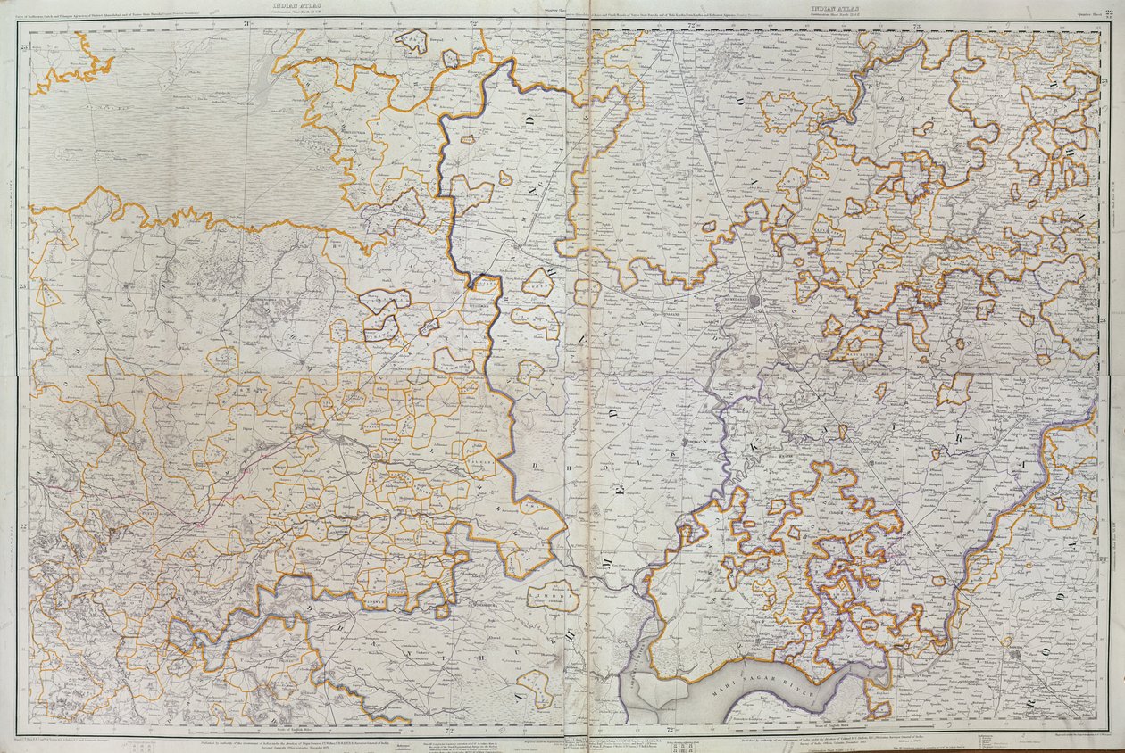
Map of the Indian state of Gujarat, published under the direction of Colonel J. T. Walker, C.B., R.E., F.R.S., Surveyor General of India, 1879 by English School

Map of the Indian state of Gujarat, published under the direction of Colonel J. T. Walker, C.B., R.E., F.R.S., Surveyor General of India, 1879

(Map of the Gujarat state of India, published under the direction of Colonel J.T. Walker, C.B., R.E., F.R.S., Surveyor General of India, 1879 )


English School

€ 136.07
Tax-free
   Configure art print
1879  ·  colour lithograph  ·  Image ID: 103220

Cultural Circles  ·  Cartography

Map of the Indian state of Gujarat, published under the direction of Colonel J. T. Walker, C.B., R.E., F.R.S., Surveyor General of India, 1879 by English School. Available as an art print on canvas, photo paper, watercolor board, natural paper, or Japanese paper.
british empire · colonial · geography · cartography · colonies · territories · territory · regions · states · boundaries · asia · mapping · british raj · little rann of cutch · kutch · states · province · asian · Private Collection / Bridgeman Images
AR/3D   View in 3D / AR zu Favoriten hinzufügen   Add to favorites    Change wall color    View picture in a room
0 Reviews

Configure art print

Picture Frame

Medium & Stretcher

Glass & Passepartout

Miscellaneous & Extras

 Save / compare configuration
Preview Icon

Summary

Gemälde
Veredelung
Keilrahmen
Museumslizenz

€ 136.07
(inkl. 20% MwSt)
   Add to cart

Bildschärfe: PERFEKT

If you'd like us to adjust the brightness, colors, or crop the image, we're happy to do this for you at no extra cost. Just get in touch!

Similar artworks selected for you

Map of Muscovy Map of the Prussian States in 1799 Bavarian Monarchy Gueldre hollandoise avec les pais, duchez et comtez voisins Duchy of Württemberg in Total Topographic Map of One Hundred Square Miles around Berlin France (Region : Nord-Pas-de-Calais, Upper Normandy, Picardy) Belgium (Region: Flanders) Map of Artois (France) and Flanders (Belgium, Netherlands) (engraving) Untitled map of Brabant: Belgium and Netherlands South Holland, North Brabant, Flemish Region, Wallonia, Brussels Region, Limburg, Netherlands, Belgium Map of Cutch and Kathiawar, published under the direction of Colonel G.C. de Pree, S.C., Surveyor General of India, 1885 Map of the Duchy of Brabant (Belgium, Netherlands) Eastern and Main Part of Franconia Map of Bavaria (Germany) County and General Government of Champagne: Including True Champagne, Brie, Reims, Rethel, Senon, Perthois, Bassigny and the Village Divided into Several Elections The States on the River of the Mosella, Reno and Saar, Germany Map of the Province of Lorraine (France) (engraving) Clivia Ducatus Map of the Northeast of Ile de France Champagne-Ardenne, Picardy, Lorraine, Franche-Comté, Burgundy, Île-de-France, France Ferro. Unbound. Similar Version Described In France (Region: Champagne-Ardenne, Lorraine, Alsace, Franche-Comté), Germany (State: Rhineland-Palatinate, Saarland) General Government of the Duchy of Burgundy, County of Bresse, Lands of Bugey, Valromey, and Gex, etc. Map of Afghanistan, 1898 Map of Luxembourg and the diocese of Trier (Germany) Geological Map of Bohemia, Surrounding of Teplice to Liberec The Theatre of War in Italy The Map is Published in Oslo (1845) and Shows Southern Norway Stanfords Map of India, 1872
Show more similar artworks

Similar artworks selected for you

Map of Muscovy Map of the Prussian States in 1799 Bavarian Monarchy Gueldre hollandoise avec les pais, duchez et comtez voisins Duchy of Württemberg in Total Topographic Map of One Hundred Square Miles around Berlin France (Region : Nord-Pas-de-Calais, Upper Normandy, Picardy) Belgium (Region: Flanders) Map of Artois (France) and Flanders (Belgium, Netherlands) (engraving) Untitled map of Brabant: Belgium and Netherlands South Holland, North Brabant, Flemish Region, Wallonia, Brussels Region, Limburg, Netherlands, Belgium Map of Cutch and Kathiawar, published under the direction of Colonel G.C. de Pree, S.C., Surveyor General of India, 1885 Map of the Duchy of Brabant (Belgium, Netherlands) Eastern and Main Part of Franconia Map of Bavaria (Germany) County and General Government of Champagne: Including True Champagne, Brie, Reims, Rethel, Senon, Perthois, Bassigny and the Village Divided into Several Elections The States on the River of the Mosella, Reno and Saar, Germany Map of the Province of Lorraine (France) (engraving) Clivia Ducatus Map of the Northeast of Ile de France Champagne-Ardenne, Picardy, Lorraine, Franche-Comté, Burgundy, Île-de-France, France Ferro. Unbound. Similar Version Described In France (Region: Champagne-Ardenne, Lorraine, Alsace, Franche-Comté), Germany (State: Rhineland-Palatinate, Saarland) General Government of the Duchy of Burgundy, County of Bresse, Lands of Bugey, Valromey, and Gex, etc. Map of Afghanistan, 1898 Map of Luxembourg and the diocese of Trier (Germany) Geological Map of Bohemia, Surrounding of Teplice to Liberec The Theatre of War in Italy The Map is Published in Oslo (1845) and Shows Southern Norway Stanfords Map of India, 1872
Show more similar artworks

More art prints by English School

Church and Cottage with Lighted Windows Portrait of a bodybuilder, c. 1898 The Portrait of King Richard III Kidbrooke Park, Kent, formerly attributed to George Lambert (1700-65) c.1740-50 Map of Europe in 1910 Portrait of the Greek philosopher Socrates (469-399 BC) - From the series “Leaders of Men” - Chromolithography - English School, 20th century Venice, 1338, after a manuscript in the Bodleian Library, from Map of Ireland from ’The History of Ireland’ by Thomas Wright, published c.1854 Detailed Map of Gallipoli Peninsula and the Dardanelles, Turkey, 1915, from Ever-flowering Rose (Rosa semperflorens), plate 284 from William Curtis Poster advertising ‘A Midsummer Night Romeo buys poison from the apothecary, illustration from Romeo and Juliet, from "The Illustrated Library Shakespeare", published in London 1890 Map of the world with possessions of the British Empire coloured red, c. 1870 Portrait of Queen Elizabeth I of England (1533-1603). Painting of the English School. 17th century. Canvas, 0.56 x 0.77 m. Pau, Musée du Château
Show more works by English School

More art prints by English School

Church and Cottage with Lighted Windows Portrait of a bodybuilder, c. 1898 The Portrait of King Richard III Kidbrooke Park, Kent, formerly attributed to George Lambert (1700-65) c.1740-50 Map of Europe in 1910 Portrait of the Greek philosopher Socrates (469-399 BC) - From the series “Leaders of Men” - Chromolithography - English School, 20th century Venice, 1338, after a manuscript in the Bodleian Library, from Map of Ireland from ’The History of Ireland’ by Thomas Wright, published c.1854 Detailed Map of Gallipoli Peninsula and the Dardanelles, Turkey, 1915, from Ever-flowering Rose (Rosa semperflorens), plate 284 from William Curtis Poster advertising ‘A Midsummer Night Romeo buys poison from the apothecary, illustration from Romeo and Juliet, from "The Illustrated Library Shakespeare", published in London 1890 Map of the world with possessions of the British Empire coloured red, c. 1870 Portrait of Queen Elizabeth I of England (1533-1603). Painting of the English School. 17th century. Canvas, 0.56 x 0.77 m. Pau, Musée du Château
Show more works by English School

More motifs from the category Cartography

Map of the Island of Santo Domingo, from “Santo Domingo Past and Present” by Samuel Hazard, published 1873 Map of France, Gallia Antiqua, from Map of Paris showing Île de la Cité, from L’Atlas de Paris by Jean de la Caille, 1714 Map No. 5 Showing the route of the Armada fleet, engraved by Augustine Ryther, 1588 Map of Cambrai, from ’Civitates Orbis Terrarum’ by Georg Braun (1541-1622) and Frans Hogenberg (1535-90), c. 1572 Map of the Western Part of the Roman Empire, 1763 MS CCC 2* f.2v Map of Palestine Map of London, from “Civitates Orbis Terrarum”, by Georg Braun (1542-1622) and Frans Hogenburg (1635-90), c. 1572 Ms 782 f.374v World map with Jerusalem in the centre, from Map and Prospect of London, c. 1710 Map of the Battle of Trafalgar, published by William Blackwood and Sons, Edinburgh and London, 1848 A Map of the coastline of Brittany, 1588 Ms 988 Vol. 3 fol. 29, Map and plan of Saint-Malo, from the Eastern Hemisphere, from a Series of World Maps published by John Tallis and Co., New York and London, 1850s F.52v Map of Florida and the Antilles, from
View More from "Cartography"

More motifs from the category Cartography

Map of the Island of Santo Domingo, from “Santo Domingo Past and Present” by Samuel Hazard, published 1873 Map of France, Gallia Antiqua, from Map of Paris showing Île de la Cité, from L’Atlas de Paris by Jean de la Caille, 1714 Map No. 5 Showing the route of the Armada fleet, engraved by Augustine Ryther, 1588 Map of Cambrai, from ’Civitates Orbis Terrarum’ by Georg Braun (1541-1622) and Frans Hogenberg (1535-90), c. 1572 Map of the Western Part of the Roman Empire, 1763 MS CCC 2* f.2v Map of Palestine Map of London, from “Civitates Orbis Terrarum”, by Georg Braun (1542-1622) and Frans Hogenburg (1635-90), c. 1572 Ms 782 f.374v World map with Jerusalem in the centre, from Map and Prospect of London, c. 1710 Map of the Battle of Trafalgar, published by William Blackwood and Sons, Edinburgh and London, 1848 A Map of the coastline of Brittany, 1588 Ms 988 Vol. 3 fol. 29, Map and plan of Saint-Malo, from the Eastern Hemisphere, from a Series of World Maps published by John Tallis and Co., New York and London, 1850s F.52v Map of Florida and the Antilles, from
View More from "Cartography"

A selection of our top sellers

Woman with a Veil, 1915 Poppies P. Modersohn-Becker, Girl Mulberry Tree, 1889 Kneeling Woman in an Orange-Red Dress View of the Dents-du-Midi from Champéry The Magpie, 1869 The Little Shepherdess A Corner of the Garden at Montgeron, 1876-7 Fir Forest I, 1901 Swimming pool, 1905 The Cliff, Étretat, Sunset, 1882-1883 The Ambassadors The Terrace, Annecy The Forest of Pines
Show more artworks

A selection of our top sellers

Woman with a Veil, 1915 Poppies P. Modersohn-Becker, Girl Mulberry Tree, 1889 Kneeling Woman in an Orange-Red Dress View of the Dents-du-Midi from Champéry The Magpie, 1869 The Little Shepherdess A Corner of the Garden at Montgeron, 1876-7 Fir Forest I, 1901 Swimming pool, 1905 The Cliff, Étretat, Sunset, 1882-1883 The Ambassadors The Terrace, Annecy The Forest of Pines
Show more artworks


What our customers think about us


Frequently Asked Questions about Meisterdrucke


Personalizing your art print at Meisterdrucke is simple and intuitive: Choose a frame, set the image size, pick a printing medium, and add suitable glazing or a stretcher frame. We also offer additional customization options like mats, fillets, and spacers. If you have any questions, our customer service team is ready to help you create your perfect artwork.

At Meisterdrucke, you can visualize your configured artwork directly in your own room. Simply upload a photo of your space and see how the artwork looks in it. If you're visiting us on a mobile device — phone or tablet — our augmented reality feature brings the picture to life and projects it right into your room. A unique experience that combines art and technology.

Choosing the right medium is often a matter of personal taste. To give you a better idea, we've provided some images for each medium. We also offer a sample set of all paper variants, so you can decide not just visually but by touch as well. You can order the sample set free of charge — only shipping costs apply.

Don't worry! At Meisterdrucke, we don't just process orders mechanically. Every order is manually reviewed by our team. If we spot any inconsistencies or issues with your configuration, we'll get in touch with you right away. And of course, our friendly and patient support team is always here to help you with your configuration. We'll work with you by phone or email to adjust your image so the final result is exactly what you had in mind.


Still have questions?

Are you interested in an art print from our manufactory but still unsure? Do you need advice on choosing the medium or help with the order?

Our experts are happy to assist you.

+43 4257 29415
support@meisterdrucke.com
Mo-Do: 7:00 - 16:00 | Fr: 7:00 - 13:00

Still have questions?

Are you interested in an art print from our manufactory but still unsure? Do you need advice on choosing the medium or help with the order?

Our experts are happy to assist you.

+43 4257 29415
support@meisterdrucke.com
Mo-Do: 7:00 - 16:00 | Fr: 7:00 - 13:00


Meisterdrucke

   Kärntner Strasse 46
        9586 Finkenstein am Faaker See
        Austria
        +43 4257 29415
        support@meisterdrucke.com
Other languages

                   
Erfahrungen & Bewertungen zu Meisterdrucke
Post.at DHL Express Quehenberger Cargoboard
Kaiser Franz Joseph

Meisterdrucke
Kärntner Strasse 46
9586 Finkenstein am Faaker See · Austria
+43 4257 29415 · support@meisterdrucke.com
Post.at DHL Express Quehenberger Cargoboard


(c) 2026 meisterdrucke.uk