support@meisterdrucke.com  ·  0043 4257 29415

Deutsch English Italiano Español Français Nederlands Português Svenska Polski Dansk
Search by artist, work title or style – e.g. Monet, Starry Night, Impressionism, Hokusai wave, nude. Describe the scene – e.g. green meadow, abstract with lots of red, dark oil painting, standing nude next to a tree.

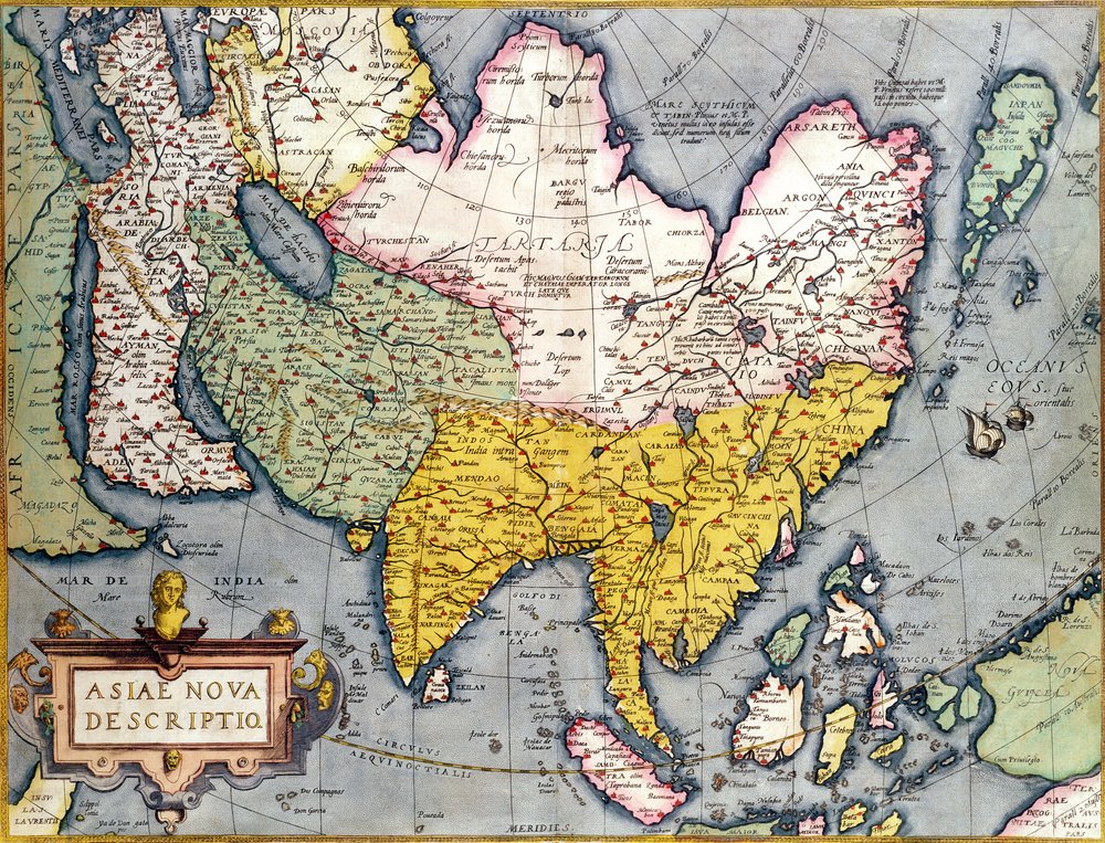
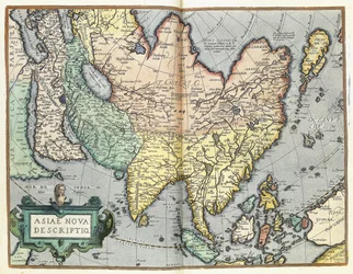
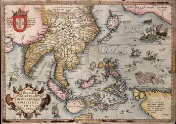
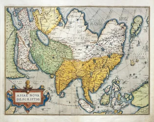
Asia: Map of the continent including Japan and the East Indies with part of New Guinea, c.1580 by Abraham Ortelius

Asia: Map of the continent including Japan and the East Indies with part of New Guinea, c.1580

(Asia: Map of the continent including Japan and the East Indies with part of New Guinea, c.1580 )


Abraham Ortelius

€ 122.91
Tax-free
   Configure art print
Undated  ·  colour engraving  ·  Image ID: 298408

Nonclassified artists  ·  Cartography

Asia: Map of the continent including Japan and the East Indies with part of New Guinea, c.1580 by Abraham Ortelius. Available as an art print on canvas, photo paper, watercolor board, natural paper, or Japanese paper.
cartography · cartouche · tartaria · russia · persia · arabia · Private Collection / Bridgeman Images
Other color versions of this image  
AR/3D   View in 3D / AR zu Favoriten hinzufügen   Add to favorites    Change wall color    View picture in a room
0 Reviews

Configure art print

Picture Frame

Medium & Stretcher

Glass & Passepartout

Miscellaneous & Extras

 Save / compare configuration
Preview Icon

Summary

Gemälde
Veredelung
Keilrahmen
Museumslizenz

€ 122.91
(inkl. 20% MwSt)
   Add to cart

Bildschärfe: PERFEKT

If you'd like us to adjust the brightness, colors, or crop the image, we're happy to do this for you at no extra cost. Just get in touch!

Similar artworks selected for you

Map of Asia Asia Asia Map of Asia, engraving Map of Asia from the Bleau Atlas Map of Asia, Nuremberg, c.1730 The theatre of the world or the new atlas Amsterdam. Geographic map of Asia by Willem Janszoon Blaeu Amsterdam Allard Asia Noviter Asia (engraving) Map of Asia, c.1696 1692 Map of Asia Pakistan, India, Sri Lanka, Nepal, Bhutan, Bangladesh, South China, Burma, Thailand, Laos, Vietnam, Cambodia, Malaysia, Brunei, Indonesia, The Philippines, Taiwan, South Japan Geography map of East India and South East Asian territory from Map of Asia. Plate from an Atlas by Willem Janszoon Blaeu Map of Asia Map of Asia, published in 1700, Paris Map of India to New Guinea, c.1570-1603 India Map of Asia from the Atlas by Joan Blaeu Map of the East Indies by Ortelius, c.1570 General Map Including Arabia, Japan, the Korean Peninsula and the Greater Part of the Indonesian Archipelago, 1631 Pakistan, India, Nepal, Bhutan, Bangladesh, Sri Lanka, East China, North Korea, South Korea, Japan, Burma, Thailand, Laos, Vietnam, Cambodia, Indonesia, Philippines, Malaysia Map of the Indies, from Theatrum Orbis Terrarum America Borealis. Map of North America Showing California as an Island, from Heinrich Scherer America, or the New World: From the Theatrum Orbis Terrarum by Abraham Ortelius, 1570 Description of the European Continent. Geography Map from Theatrum Orbis Terrarum by Abraham Ortelius
Show more similar artworks

More art prints by Abraham Ortelius

The Expedition of Alexander the Great, from the Map of the Pacific, China and America, 1589, by Abrahamus Ortelius (1527-98) Map of Ancient Egypt, 1584 World Map Typus Orbis Terrarum Map of Tartary, Northern-Central Asia, from Theatrum Orbis Terrarum by Abraham Ortelius Map of the Voyage of the Argonauts, from the “Theatrum Orbis Terrarum”, 1603 Map of the world: “Typus Orbis Terrarum”, from Ortelius Celebrated places in Judea and Israel, from the Aegypti Recentior Descriptio. - Carthaginis Celeberrimi Sinus Typus. Geography map of Egypt with the cities of the Nile and Carthage (Tunisia) from “Theatrum Orbis Terrarum” by Abraham Ortelius Typus Orbis Terrarum, map of the world, from Ortelius Map of Europe Map of Ancient Egypt - by Abraham Ortelius, Antwerp Pontus Euxinus A. Velleius. Islandia Old historical map of ancient Thrace, mostly in Latin and with very little Greek, made in 1585. The map also shows part of Asia Minor, Moesia Inferior, and ancient Greece along with some Aegean islands. There are some anachronisms on the map, such as
Show more works by Abraham Ortelius

More motifs from the category Cartography

Map of Jerusalem, 1661 Map of the Sea of Maluku, from the Cosmographie Universelle Map of Europe, published in 1700, Paris Map of Cambridge, from Map of India, published under the direction of Colonel H.R. Thuillier, Surveyor General of India La Naptune Francois, ou Atlas des Cartes Marines, 1693 Detail of the Ile de la Cité, from the Map of Paris c. 1540, known as the Plan de la Tapisserie, made as a Tapestry c. 1570 Map of the World, Based on Descriptions and Coordinates Given in “Geographia”, by Ptolemy (Claudius Ptolemaeus of Alexandria) (c. 90-168 AD) A Map of Wapping, London, 1746 Map of Toledo, from Map of the Island of Minorca, c.1740 Map of Rocroi, from Map of Australia and New Zealand Map of the city of Rome, engraved by the artist, 1557 Map of Ireland
View More from "Cartography"

A selection of our top sellers

Boy Viewing Mount Fuji, 1839 The Harbour at Sunset, Opus 236 (Saint-Tropez), 1892 Poster advertising Buddha Small Rhythmic Landscape The Origin of the World Paradiso, Canto 31: The saintly throng form a rose in the empyrean The Isle of the Dead Spring, from a series depicting the four seasons, 1573 The Wild Hunt of Odin, 1872 Avenue in the Park of Kammer Castle, 1912 Portrait of a young woman, drawing The Terrace, Annecy Landscape, The Parc Monceau Several Circles, 1926
Show more artworks


What our customers think about us


Frequently Asked Questions about Meisterdrucke


Personalizing your art print at Meisterdrucke is simple and intuitive: Choose a frame, set the image size, pick a printing medium, and add suitable glazing or a stretcher frame. We also offer additional customization options like mats, fillets, and spacers. If you have any questions, our customer service team is ready to help you create your perfect artwork.

At Meisterdrucke, you can visualize your configured artwork directly in your own room. Simply upload a photo of your space and see how the artwork looks in it. If you're visiting us on a mobile device — phone or tablet — our augmented reality feature brings the picture to life and projects it right into your room. A unique experience that combines art and technology.

Choosing the right medium is often a matter of personal taste. To give you a better idea, we've provided some images for each medium. We also offer a sample set of all paper variants, so you can decide not just visually but by touch as well. You can order the sample set free of charge — only shipping costs apply.

Don't worry! At Meisterdrucke, we don't just process orders mechanically. Every order is manually reviewed by our team. If we spot any inconsistencies or issues with your configuration, we'll get in touch with you right away. And of course, our friendly and patient support team is always here to help you with your configuration. We'll work with you by phone or email to adjust your image so the final result is exactly what you had in mind.


Still have questions?

Are you interested in an art print from our manufactory but still unsure? Do you need advice on choosing the medium or help with the order?

Our experts are happy to assist you.

+43 4257 29415
support@meisterdrucke.com
Mo-Do: 7:00 - 16:00 | Fr: 7:00 - 13:00

Still have questions?

Are you interested in an art print from our manufactory but still unsure? Do you need advice on choosing the medium or help with the order?

Our experts are happy to assist you.

+43 4257 29415
support@meisterdrucke.com
Mo-Do: 7:00 - 16:00 | Fr: 7:00 - 13:00


Meisterdrucke

   Kärntner Strasse 46
        9586 Finkenstein am Faaker See
        Austria
        +43 4257 29415
        support@meisterdrucke.com
Other languages

                   
Erfahrungen & Bewertungen zu Meisterdrucke
Post.at DHL Express Quehenberger Cargoboard
Kaiser Franz Joseph

Meisterdrucke
Kärntner Strasse 46
9586 Finkenstein am Faaker See · Austria
+43 4257 29415 · support@meisterdrucke.com
Post.at DHL Express Quehenberger Cargoboard


(c) 2026 meisterdrucke.uk