Search by artist, work title or style – e.g. Monet, Starry Night, Impressionism, Hokusai wave, nude. Describe the scene – e.g. green meadow, abstract with lots of red, dark oil painting, standing nude next to a tree.

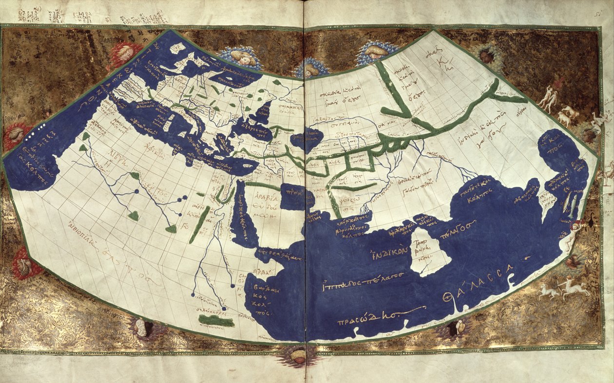
Map of the known world, from

Map of the known world, from 'Geographia'

(Map of the known world, from 'Geographia' )


Ptolemy

€ 116.9
Enthält 0% MwSt.
   Configure art print
Undated  ·  vellum  ·  Picture ID: 89175

Ancient Art  ·  Cartography

Map of the known world, from 'Geographia' by Ptolemy. Available as an art print on canvas, photo paper, watercolor board, uncoated paper or Japanese paper.
map of the known world · geographic · claude ptolemee · ocean · manuscript · medieval · Biblioteca Marciana, Venice, Italy / Bridgeman Images
Other color variations of this picture  
AR/3D   View in 3D / AR zu Favoriten hinzufügen   Add to favorites    Select wall color    View painting in a room
0 Reviews

Configure art print

Picture Frame

Medium & Stretcher

Glass & Passepartout

Miscellaneous & Extras

 Save / compare configuration
Preview Icon

Summary

Gemälde
Veredelung
Keilrahmen
Museumslizenz

€ 116.9
(inkl. 20% MwSt)
   Add to cart

Bildschärfe: PERFEKT

Should you desire adjustments to brightness and color, or a custom crop of the motif, we are happy to make these changes at no additional cost to you. Please do not hesitate to contact us.

Similar artworks selected for you

Map of the world, from "Insularium Illustratum", by Enrico Martello, being an account of the islands, chiefly of the Mediterranean, Italian, c.1470 Map of the World Ptolemaic World Map from Ms Lat 463 Fol.75v-76r Map of the World with the Twelve Winds Map of the World based on a description by Ptolemaeus Atlas of Borso d Map of the World Atlas - by Andrea Bianco World map by Andrea Bianco Map of Africa, after an original of 1447 Europe and Northern Africa Large Mappa Mundi, from Map of the world, based on descriptions and co-ordinates given in World map of Claude Ptolemy. The human heads blowing air represent the different winds. In Map of Ptolemy published in 1482 The First Edition of Ptolemy Printed in Germany, and the First with Woodcut Maps. Original Binding. Map of the world, c.1320-25 Map of the world by sailor cartographer Andrea Bianco (15th century) Catalan Map of the European Continent with the Atlantic and the Mediterranean Sea World Map, Mundu [sic] Spericum... Cognosces Diligentia Joani Mathei Contareni, by Contarini, Giovanni and Francesco Rosselli Map of the Holy Land Charts 2v and 3r of the Mediceo Atlas (Gaddi 9) Eastern Europe and Central Asia, from Atlas of the World in Thirty-Three Maps Catalan Atlas, Sheet 7 and 8 Map of the World, Based on Descriptions and Coordinates Given in Provence and Italy (detail) Illustration from the
Show more similar artworks

Other art prints by Ptolemy

Map of the known world, from Map of the world, based on descriptions and co-ordinates given in Ulm Ptolemy World Map Map Depicting the North of Africa, from an Atlas by Ptolemy, 1st Half 16th Century Map of Central Europe (detail) Map of North Africa and West Africa, published in Strasbourg in 1522 Map of the World, Based on Descriptions and Coordinates Given in Map of France, from Map of Spain and Portugal, from Historiated initial Map of the World, 1486 Map of Arabia, the Persian Gulf and the Indian Sea Map of Phoenicia, Mesopotamia and Babylon Map of the British Isles, from Map of Gaul, Belgium, Lyon and Aquitaine
Discover more works by Ptolemy

Other motives from the category Cartography

Map of Europe, Published in 1700, Paris Map of Constantinople and Surrounding Areas, 1855-63 Map of the Northern Sky with Representations of the Constellations Map of Asia, Nuremberg Map of Calicut, from Map showing the world trade shipping routes, cartography by Pierre Duval published in 1686, Paris Map of South America Map of the Heilsberg, published by William Blackwood and Sons, Edinburgh and London, 1848 Map Showing the Geography of the Hebrews and Exhibiting the Dispersion of the Descendants of Noah Map of Palestine, Palestina Antiqua, from Map of Basel Map of Naples, c.1600 Geo-Hydrographic Mappamonde View of Quebec, cartouche of a map depicting St. Lawrence River from Sorel, 1699 A New Land and Water Map of the Entire Earth
View More from "Cartography"

Excerpt from our top sellers

Whaling in the Polar Sea Female Nude Propping Herself Up with Long Hair Almond Blossom The Nightmare, 1781 Whimsical, 1930 Boy viewing Mount Fuji, 1839 The School Exam Wheat Field Hygieia Winter Landscape, 1835-8 Pergola on Capri with View of Vesuvius Boys Bathing Stag Beetle Red Boats, Argenteuil Suigin Grove and Masaki, on the Sumida River, from
Show More Artworks


What our customers think about us


Frequently Asked Questions about Meisterdrucke


Personalizing your art print at Meisterdrucke is a simple and intuitive process that allows you to design an artwork exactly to your specifications: Choose a frame, determine the image size, decide on a printing medium, and add suitable glazing or a stretcher frame. We also offer customization options such as mats, fillets, and spacers. Our customer service is available to help you design your perfect artwork.

At Meisterdrucke, you have the fascinating option to visualize the artwork you configured directly in your own space. For a tailored preview, simply upload a photo of your room and let the artwork appear on it. If you visit us via a mobile device, be it a phone or tablet, our augmented reality feature brings the image to life and seamlessly projects it into your space. An experience that uniquely combines art and technology.

Choosing the medium is often a matter of personal taste. To give you a clearer idea, we have provided some images for each medium. For a holistic experience, we also offer you a sample set of all paper variants so you can make a decision not just visually but also haptically. You can take advantage of the sample set free of charge – only the shipping costs will apply. You can order the sample set directly.

Do not worry. At Meisterdrucke, we do not proceed mechanically. We manually review each order. If there are any inconsistencies or peculiarities in the configuration, we will immediately contact you. Of course, our courteous and patient support is always at your side to assist you with the configuration. Together with you, we adjust your image by phone or email so that the final result exactly meets your expectations.


Do you have any questions?

Are you interested in an art print from our manufactory but still unsure? Do you need advice on choosing the medium or help with the order?

Our experts are happy to assist you.

+43 4257 29415
support@meisterdrucke.com
Mo-Do: 7:00 - 16:00 | Fr: 7:00 - 13:00

Do you have any questions?

Are you interested in an art print from our manufactory but still unsure? Do you need advice on choosing the medium or help with the order?

Our experts are happy to assist you.

+43 4257 29415
support@meisterdrucke.com
Mo-Do: 7:00 - 16:00 | Fr: 7:00 - 13:00


Meisterdrucke

   Kärntner Strasse 46
        9586 Finkenstein am Faaker See
        Austria
        +43 4257 29415
        support@meisterdrucke.com
Other languages

                   
Erfahrungen & Bewertungen zu Meisterdrucke
Post.at DHL Express Quehenberger Cargoboard
Kaiser Franz Joseph

Meisterdrucke
Kärntner Strasse 46
9586 Finkenstein am Faaker See · Austria
+43 4257 29415 · office@meisterdrucke.com
Post.at DHL Express Quehenberger Cargoboard


Meisterdrucke 2764 Bewertungen auf ProvenExpert.com

(c) 2025 meisterdrucke.uk