support@meisterdrucke.com  ·  0043 4257 29415

Deutsch English Italiano Español Français Nederlands Português Svenska Polski Dansk
Search by artist, work title or style – e.g. Monet, Starry Night, Impressionism, Hokusai wave, nude. Describe the scene – e.g. green meadow, abstract with lots of red, dark oil painting, standing nude next to a tree.

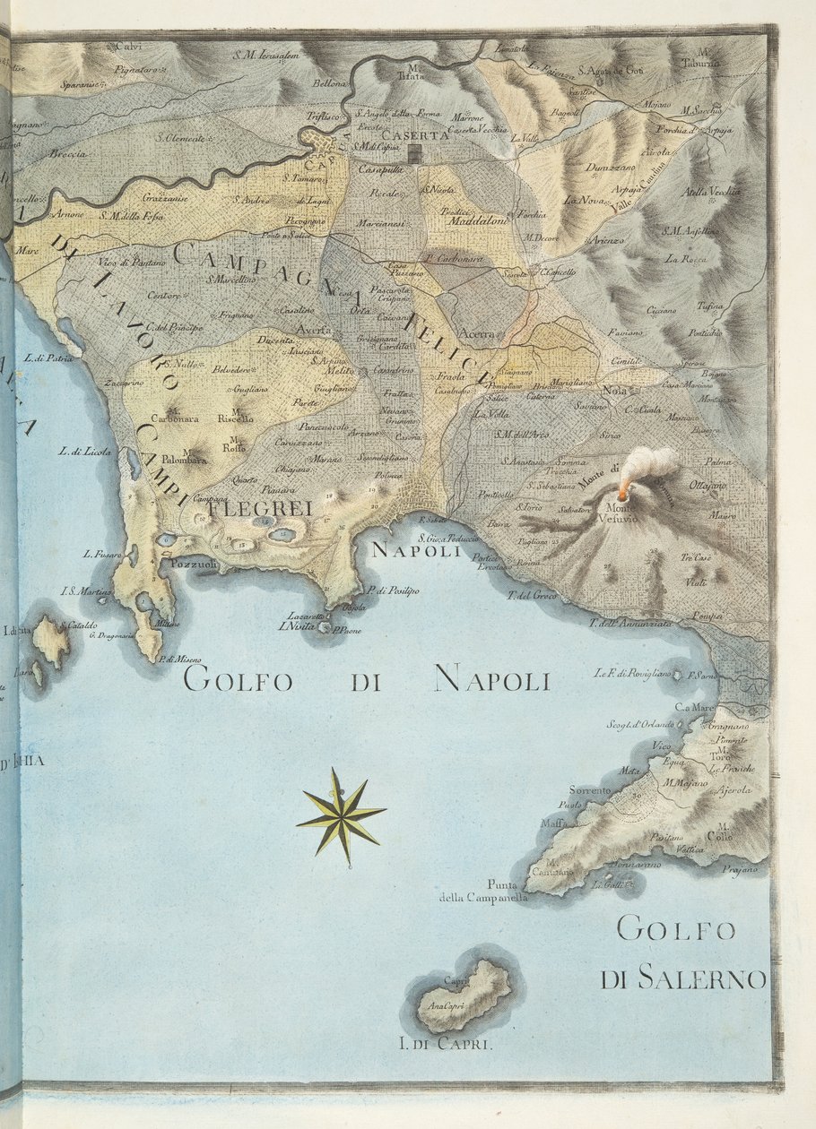
Map of the Gulf of Naples and surrounding area from

Map of the Gulf of Naples and surrounding area from 'Campi Phlegraei: Observations on the Volcanoes of the Two Sicilies', by Sir William Hamilton (1730-1803), published 1776

(Map of the Gulf of Naples and surrounding area from 'Campi Phlegraei: Observations on the Volcanoes of the Two Sicilies', by Sir William Hamilton (1730-1803), published 1776 (hand coloured engraving))


Pietro Fabris

€ 129.33
Tax-free
   Configure art print
1776  ·  hand coloured engraving  ·  Image ID: 187836

Nonclassified artists  ·  Cartography

Map of the Gulf of Naples and surrounding area from 'Campi Phlegraei: Observations on the Volcanoes of the Two Sicilies', by Sir William Hamilton (1730-1803), published 1776 by Pietro Fabris. Available as an art print on canvas, photo paper, watercolor board, natural paper, or Japanese paper.
Private Collection / Bridgeman Images
AR/3D   View in 3D / AR zu Favoriten hinzufügen   Add to favorites    Change wall color    View picture in a room
0 Reviews

Configure art print

Picture Frame

Medium & Stretcher

Glass & Passepartout

Miscellaneous & Extras

 Save / compare configuration
Preview Icon

Summary

Gemälde
Veredelung
Keilrahmen
Museumslizenz

€ 129.33
(inkl. 20% MwSt)
   Add to cart

Bildschärfe: PERFEKT

If you'd like us to adjust the brightness, colors, or crop the image, we're happy to do this for you at no extra cost. Just get in touch!

Similar artworks selected for you

1794 map of the Gulf of Naples Detail of a geographical map representing Southern Italy (regions of Campania, Calabria, Sicily, Puglia, Molise and Abruzzo). 19th century Map of Rhode Island at the time of its occupation 1780-81 by the French Army on the orders of Jean-Baptiste de Vimeur Count of Rochambeau Roy Military Survey of Scotland S. Phelipe de Porto Bello Wonder Atlas - Sicily Sardinia, Italy Map of Gulf of Gaeta from Ipswich Bay and Cape Ann Roy Military Survey of Scotland Plano del Puerto y Rio Guayaquil en el Mar de el Sur Map of the Surroundings of Villefranche in the Count of Nice Levee in October 1748 Cartography: Comparative Heights of the Main Mountains of Italy, Synoptic Table with Reliefs, Volcanoes, Cities of Milan and Rome, Sea Level Center of Italy - by A Sicily Map of the bay and city of S. Phelipe de Portobelo Map of Mauritius, illustration from View of the Rock of Gibraltar and a Map of the Strait of Gibraltar Altnaharra, Roy Military Survey of Scotland The Island of Martinique, from Map containing the island and kingdom of Sicily, with a part of Naples, and other adjacent coasts including the Tyrrhenean Sea Map of France, Spain and North-West Africa, from the Map of the Island of Martinique, 1599 The Island of Jamaica Patagonia, from a Series of World Maps published by John Tallis und Co., New York and London, 1850s Corsica, France Detail of Heligoland from a map of Denmark, 1730 Map of the Peloponnesus A new and accurate Map of the Island of Carriacou in the West Indies
Show more similar artworks

More art prints by Pietro Fabris

Eruption of Vesuvius, Monday 9th August 1779, Plate 3, Published as a Supplement to View of Mount Vesuvius from the sea shore, from View of the Great Eruption of Vesuvius from the Mole of Naples in the Night of 20 October 1767, Plate 6 from Crater of Mount Vesuvius from an Original Drawing Executed at the Scene in 1756, Plate 10 from “Campi Phlegrai: Observations of the Volcanoes of the Two Sicilies”, by Sir William Hamilton (1730-1803) Map of the Gulf of Naples and surrounding area from The handball game (detail) View from the Sea of the Promontory, Capo dell Italian Ball Game (Palla a Bracciale) in Interior Plate X from Campi Phlegraei: Observations of the Volcanoes of the Two Sicilies by William Hamilton Noble dance and feast scene in Naples. Dancers in a park. 18th century. Naples, Museo Nazionale di San Martino View of the Island of Ischia from the sea, Plate XXX, from View Taken from the Bottom of the Crater of Monte Nuovo, Plate XXVII, from The erupting Vesuvius. This gouache was carried out by Pierre Fabris, at the request of Sir William Hamilton, English ambassador to Naples. Bibl. Braidense, Milan Fete at Naples on the Occasion of the Marriage of King Ferdinand I (1751-1825) to the Archduchess Maria Carolina of Austria (1752-1814) View of the Porto Pavone in the Island of Nisida, Plate XXII from
Show more works by Pietro Fabris

More motifs from the category Cartography

Map of Africa, published in 1700, Paris Map of Surrey, described and divided into hundreds Map of Australia and Magellan Island from The coasts of France, England and Ireland, from Collection of Dutch Marine Maps Map of North Africa, c.1580s Topographical Map and Survey of the Village of Issy, 1740 Map of Europe, illustration from Le Magasin Pittoresque, 1849 Renaissance map of Europe, Jacopo Russo (after) 1528 Map of Alexander the Great Map of London, 1852 Map of Spain and Portugal showing the political divisions in the country at the death of Alfonso III, King of Leon, from Map illustrating the Capture of Buda, 1686 Map of the Battle of Bautzen, published by William Blackwood and Sons, Edinburgh and London, 1848 Map of the Siege of York in 1781, from Map of Chinese Turkestan, from “On Ancient Central-Asian Tracks” by Stein, published 1933
View More from "Cartography"

A selection of our top sellers

Wheatfield Lady Godiva Starry Night Portrait of a Young Woman Resting Figure, 1930 Garden in Bloom, Arles, July 1888 The Great Piece of Turf, 1503 Poppy Field, 1873 Sheerness as seen from the Nore The Tortoise Trainer, 1906 The times of day: The evening, 1821-1822 Flowering Front Garden The Cannon Shot, c. 1680 The Mountain Mowers, First Version Sailing Ships
Show more artworks


What our customers think about us


Frequently Asked Questions about Meisterdrucke


Personalizing your art print at Meisterdrucke is simple and intuitive: Choose a frame, set the image size, pick a printing medium, and add suitable glazing or a stretcher frame. We also offer additional customization options like mats, fillets, and spacers. If you have any questions, our customer service team is ready to help you create your perfect artwork.

At Meisterdrucke, you can visualize your configured artwork directly in your own room. Simply upload a photo of your space and see how the artwork looks in it. If you're visiting us on a mobile device — phone or tablet — our augmented reality feature brings the picture to life and projects it right into your room. A unique experience that combines art and technology.

Choosing the right medium is often a matter of personal taste. To give you a better idea, we've provided some images for each medium. We also offer a sample set of all paper variants, so you can decide not just visually but by touch as well. You can order the sample set free of charge — only shipping costs apply.

Don't worry! At Meisterdrucke, we don't just process orders mechanically. Every order is manually reviewed by our team. If we spot any inconsistencies or issues with your configuration, we'll get in touch with you right away. And of course, our friendly and patient support team is always here to help you with your configuration. We'll work with you by phone or email to adjust your image so the final result is exactly what you had in mind.


Still have questions?

Are you interested in an art print from our manufactory but still unsure? Do you need advice on choosing the medium or help with the order?

Our experts are happy to assist you.

+43 4257 29415
support@meisterdrucke.com
Mo-Do: 7:00 - 16:00 | Fr: 7:00 - 13:00

Still have questions?

Are you interested in an art print from our manufactory but still unsure? Do you need advice on choosing the medium or help with the order?

Our experts are happy to assist you.

+43 4257 29415
support@meisterdrucke.com
Mo-Do: 7:00 - 16:00 | Fr: 7:00 - 13:00


Meisterdrucke

   Kärntner Strasse 46
        9586 Finkenstein am Faaker See
        Austria
        +43 4257 29415
        support@meisterdrucke.com
Other languages

                   
Erfahrungen & Bewertungen zu Meisterdrucke
Post.at DHL Express Quehenberger Cargoboard
Kaiser Franz Joseph

Meisterdrucke
Kärntner Strasse 46
9586 Finkenstein am Faaker See · Austria
+43 4257 29415 · support@meisterdrucke.com
Post.at DHL Express Quehenberger Cargoboard


(c) 2026 meisterdrucke.uk