support@meisterdrucke.com  ·  0043 4257 29415

Deutsch English Italiano Español Français Nederlands Português Svenska Polski Dansk
Search by artist, work title or style – e.g. Monet, Starry Night, Impressionism, Hokusai wave, nude. Describe the scene – e.g. green meadow, abstract with lots of red, dark oil painting, standing nude next to a tree.

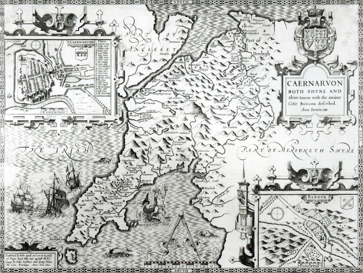
Map of Caernarvon, 1616 by John Speed

Map of Caernarvon, 1616

(Map of Caernarvon, 1616 )


John Speed

€ 124.41
Tax-free
   Configure art print
1616  ·  engraving  ·  Image ID: 96367

Nonclassified artists  ·  Cartography

Map of Caernarvon, 1616 by John Speed. Available as an art print on canvas, photo paper, watercolor board, natural paper, or Japanese paper.
shire · places · anglesey · irish sea · bangor · geography · cartography · geographical · coat of arms · hills · wales · welsh · caernarvonshire · Private Collection / Bridgeman Images
AR/3D   View in 3D / AR zu Favoriten hinzufügen   Add to favorites    Change wall color    View picture in a room
0 Reviews

Configure art print

Picture Frame

Medium & Stretcher

Glass & Passepartout

Miscellaneous & Extras

 Save / compare configuration
Preview Icon

Summary

Gemälde
Veredelung
Keilrahmen
Museumslizenz

€ 124.41
(inkl. 20% MwSt)
   Add to cart

Bildschärfe: PERFEKT

If you'd like us to adjust the brightness, colors, or crop the image, we're happy to do this for you at no extra cost. Just get in touch!

Similar artworks selected for you

The County of Leinster with the City of Dublin Described, engraved by Jodocus Hondius, from The Province of Connaught with the City of Galway Described, engraved by Jodocus Hondius, from Map of the Travels of Abraham, Isaac and Jacob, 1652 A Map of the Country and City of Panama. Part. 3 : Chap : 5. (engraving) The Plantation of Ulster Map of Russia From: Rerum Moscoviticarum commentarii Map of the Tribe of Asher, 1590 The Republic of Genoa, Map by Jan Baptist Vrients from Theatrum Orbis Terrarum by Abraham Ortelius Cyprus and the islands of Stalimini (Lemnos), Chios, Mitilene, Negroponte, Cerigo and Rhodes Ireland The Siege of La Rochelle Guinea, Libya - Africa (engraving) 1593 Map of the Danube by Cornelis de Jode Northwest Africa with the Canaries (engraving) Gloucestershire Map of New France dedicated to Colbert by Duchesneau, Intendant, 1681 Portland Bill to Portsmouth: The Pursuit of the Spanish Armada by the English Fleet Forty Years Travels of the Children of Israel A Map of Samaria, from New and Accurate Map of the Lands and Kingdoms of California, New Spain, Mexico, and Peru Frieslandt Events of 1640 Map of Brazil Theatrum Orbis Terrarum A New and Accurate Plan of the City and Harbour of Cartagena, Showing the Descent of That Place by the British Fleet and Land Forces, Under the Command of the Admirals Vernon and Ogle and General Wentworth in March & April 1741 Map of Normandy after an illustration from Theatrum Orbis Terrarum sive Atlas Novus by Willem and Joan Blaeu, plate representing Normandia Ducatus Island of Ischia, Italy, in Map of Europe, from a facsimile of the ‘Miller Atlas’ by Pedro and Jorge Reinel, and Lopo Homem, made in 1519 Map of Palestine, from a Passover Haggadah, printed in 1695
Show more similar artworks

Similar artworks selected for you

The County of Leinster with the City of Dublin Described, engraved by Jodocus Hondius, from The Province of Connaught with the City of Galway Described, engraved by Jodocus Hondius, from Map of the Travels of Abraham, Isaac and Jacob, 1652 A Map of the Country and City of Panama. Part. 3 : Chap : 5. (engraving) The Plantation of Ulster Map of Russia From: Rerum Moscoviticarum commentarii Map of the Tribe of Asher, 1590 The Republic of Genoa, Map by Jan Baptist Vrients from Theatrum Orbis Terrarum by Abraham Ortelius Cyprus and the islands of Stalimini (Lemnos), Chios, Mitilene, Negroponte, Cerigo and Rhodes Ireland The Siege of La Rochelle Guinea, Libya - Africa (engraving) 1593 Map of the Danube by Cornelis de Jode Northwest Africa with the Canaries (engraving) Gloucestershire Map of New France dedicated to Colbert by Duchesneau, Intendant, 1681 Portland Bill to Portsmouth: The Pursuit of the Spanish Armada by the English Fleet Forty Years Travels of the Children of Israel A Map of Samaria, from New and Accurate Map of the Lands and Kingdoms of California, New Spain, Mexico, and Peru Frieslandt Events of 1640 Map of Brazil Theatrum Orbis Terrarum A New and Accurate Plan of the City and Harbour of Cartagena, Showing the Descent of That Place by the British Fleet and Land Forces, Under the Command of the Admirals Vernon and Ogle and General Wentworth in March & April 1741 Map of Normandy after an illustration from Theatrum Orbis Terrarum sive Atlas Novus by Willem and Joan Blaeu, plate representing Normandia Ducatus Island of Ischia, Italy, in Map of Europe, from a facsimile of the ‘Miller Atlas’ by Pedro and Jorge Reinel, and Lopo Homem, made in 1519 Map of Palestine, from a Passover Haggadah, printed in 1695
Show more similar artworks

More art prints by John Speed

A new and accurate map of the world, 1676 The Turkish Empire, 1626 Maps of Holy Island and Farne Island, Northumberland, from Map of Tartary by John Speed The Bishoprick and City of Durham, engraved by Jodocus Hondius (1563-1612) from John Speed’s “Theatre of the Empire of Great Britain”, published by John Sudbury and George Humble, 1611-12 (hand-coloured) Middlesex described with the most famous cities of London and Westminster, from Speed The Kingdome of Scotland, engraved by Jodocus Hondius (1563-1612) from ‘Theatre of the Empire of Great Britain’, published by John Sudbury and George Humble, 1611-12 A New Map of the Roman Empire, from "A Prospect of the Most Famous Parts of the World", published by Bassett and Chiswell, 1676 Lancashire in 1610, from John Speed’s ’Theatre of the Empire of Great Britaine’, first edition, published 1611-12 Wales, engraved by Jodocus Hondius (1563-1612) from John Speed’s ’Theatre of the Empire of Great Britain’, published by John Sudbury and George Humble, 1611-12 Map of Cornwall from the Britain as It Was Divided in the Time of the English Saxons, 1616 The County of Warwick, the Shire Town and the City of Coventry, engraved by Jodocus Hondius (1563-1612), from John Speed’s ’Theatre of the Empire of Great Britain’, published by John Sudbury and George Humb Map of Northumberland, from Map depicting the Invasions of England and Ireland with all their Civil Wars since the Conquest, c. 1627
Show more works by John Speed

More art prints by John Speed

A new and accurate map of the world, 1676 The Turkish Empire, 1626 Maps of Holy Island and Farne Island, Northumberland, from Map of Tartary by John Speed The Bishoprick and City of Durham, engraved by Jodocus Hondius (1563-1612) from John Speed’s “Theatre of the Empire of Great Britain”, published by John Sudbury and George Humble, 1611-12 (hand-coloured) Middlesex described with the most famous cities of London and Westminster, from Speed The Kingdome of Scotland, engraved by Jodocus Hondius (1563-1612) from ‘Theatre of the Empire of Great Britain’, published by John Sudbury and George Humble, 1611-12 A New Map of the Roman Empire, from "A Prospect of the Most Famous Parts of the World", published by Bassett and Chiswell, 1676 Lancashire in 1610, from John Speed’s ’Theatre of the Empire of Great Britaine’, first edition, published 1611-12 Wales, engraved by Jodocus Hondius (1563-1612) from John Speed’s ’Theatre of the Empire of Great Britain’, published by John Sudbury and George Humble, 1611-12 Map of Cornwall from the Britain as It Was Divided in the Time of the English Saxons, 1616 The County of Warwick, the Shire Town and the City of Coventry, engraved by Jodocus Hondius (1563-1612), from John Speed’s ’Theatre of the Empire of Great Britain’, published by John Sudbury and George Humb Map of Northumberland, from Map depicting the Invasions of England and Ireland with all their Civil Wars since the Conquest, c. 1627
Show more works by John Speed

More motifs from the category Cartography

Map of the Island of Santo Domingo, from “Santo Domingo Past and Present” by Samuel Hazard, published 1873 Map of France, Gallia Antiqua, from Map of Paris showing Île de la Cité, from L’Atlas de Paris by Jean de la Caille, 1714 Map No. 5 Showing the route of the Armada fleet, engraved by Augustine Ryther, 1588 Map of Cambrai, from ’Civitates Orbis Terrarum’ by Georg Braun (1541-1622) and Frans Hogenberg (1535-90), c. 1572 Map of the Western Part of the Roman Empire, 1763 MS CCC 2* f.2v Map of Palestine Map of London, from “Civitates Orbis Terrarum”, by Georg Braun (1542-1622) and Frans Hogenburg (1635-90), c. 1572 Ms 782 f.374v World map with Jerusalem in the centre, from Map and Prospect of London, c. 1710 Map of the Battle of Trafalgar, published by William Blackwood and Sons, Edinburgh and London, 1848 A Map of the coastline of Brittany, 1588 Ms 988 Vol. 3 fol. 29, Map and plan of Saint-Malo, from the Eastern Hemisphere, from a Series of World Maps published by John Tallis and Co., New York and London, 1850s F.52v Map of Florida and the Antilles, from
View More from "Cartography"

More motifs from the category Cartography

Map of the Island of Santo Domingo, from “Santo Domingo Past and Present” by Samuel Hazard, published 1873 Map of France, Gallia Antiqua, from Map of Paris showing Île de la Cité, from L’Atlas de Paris by Jean de la Caille, 1714 Map No. 5 Showing the route of the Armada fleet, engraved by Augustine Ryther, 1588 Map of Cambrai, from ’Civitates Orbis Terrarum’ by Georg Braun (1541-1622) and Frans Hogenberg (1535-90), c. 1572 Map of the Western Part of the Roman Empire, 1763 MS CCC 2* f.2v Map of Palestine Map of London, from “Civitates Orbis Terrarum”, by Georg Braun (1542-1622) and Frans Hogenburg (1635-90), c. 1572 Ms 782 f.374v World map with Jerusalem in the centre, from Map and Prospect of London, c. 1710 Map of the Battle of Trafalgar, published by William Blackwood and Sons, Edinburgh and London, 1848 A Map of the coastline of Brittany, 1588 Ms 988 Vol. 3 fol. 29, Map and plan of Saint-Malo, from the Eastern Hemisphere, from a Series of World Maps published by John Tallis and Co., New York and London, 1850s F.52v Map of Florida and the Antilles, from
View More from "Cartography"

A selection of our top sellers

Woman with a Veil, 1915 Poppies P. Modersohn-Becker, Girl Mulberry Tree, 1889 Kneeling Woman in an Orange-Red Dress View of the Dents-du-Midi from Champéry The Magpie, 1869 The Little Shepherdess A Corner of the Garden at Montgeron, 1876-7 Fir Forest I, 1901 Swimming pool, 1905 The Cliff, Étretat, Sunset, 1882-1883 The Ambassadors The Terrace, Annecy The Forest of Pines
Show more artworks

A selection of our top sellers

Woman with a Veil, 1915 Poppies P. Modersohn-Becker, Girl Mulberry Tree, 1889 Kneeling Woman in an Orange-Red Dress View of the Dents-du-Midi from Champéry The Magpie, 1869 The Little Shepherdess A Corner of the Garden at Montgeron, 1876-7 Fir Forest I, 1901 Swimming pool, 1905 The Cliff, Étretat, Sunset, 1882-1883 The Ambassadors The Terrace, Annecy The Forest of Pines
Show more artworks


What our customers think about us


Frequently Asked Questions about Meisterdrucke


Personalizing your art print at Meisterdrucke is simple and intuitive: Choose a frame, set the image size, pick a printing medium, and add suitable glazing or a stretcher frame. We also offer additional customization options like mats, fillets, and spacers. If you have any questions, our customer service team is ready to help you create your perfect artwork.

At Meisterdrucke, you can visualize your configured artwork directly in your own room. Simply upload a photo of your space and see how the artwork looks in it. If you're visiting us on a mobile device — phone or tablet — our augmented reality feature brings the picture to life and projects it right into your room. A unique experience that combines art and technology.

Choosing the right medium is often a matter of personal taste. To give you a better idea, we've provided some images for each medium. We also offer a sample set of all paper variants, so you can decide not just visually but by touch as well. You can order the sample set free of charge — only shipping costs apply.

Don't worry! At Meisterdrucke, we don't just process orders mechanically. Every order is manually reviewed by our team. If we spot any inconsistencies or issues with your configuration, we'll get in touch with you right away. And of course, our friendly and patient support team is always here to help you with your configuration. We'll work with you by phone or email to adjust your image so the final result is exactly what you had in mind.


Still have questions?

Are you interested in an art print from our manufactory but still unsure? Do you need advice on choosing the medium or help with the order?

Our experts are happy to assist you.

+43 4257 29415
support@meisterdrucke.com
Mo-Do: 7:00 - 16:00 | Fr: 7:00 - 13:00

Still have questions?

Are you interested in an art print from our manufactory but still unsure? Do you need advice on choosing the medium or help with the order?

Our experts are happy to assist you.

+43 4257 29415
support@meisterdrucke.com
Mo-Do: 7:00 - 16:00 | Fr: 7:00 - 13:00


Meisterdrucke

   Kärntner Strasse 46
        9586 Finkenstein am Faaker See
        Austria
        +43 4257 29415
        support@meisterdrucke.com
Other languages

                   
Erfahrungen & Bewertungen zu Meisterdrucke
Post.at DHL Express Quehenberger Cargoboard
Kaiser Franz Joseph

Meisterdrucke
Kärntner Strasse 46
9586 Finkenstein am Faaker See · Austria
+43 4257 29415 · support@meisterdrucke.com
Post.at DHL Express Quehenberger Cargoboard


(c) 2026 meisterdrucke.uk