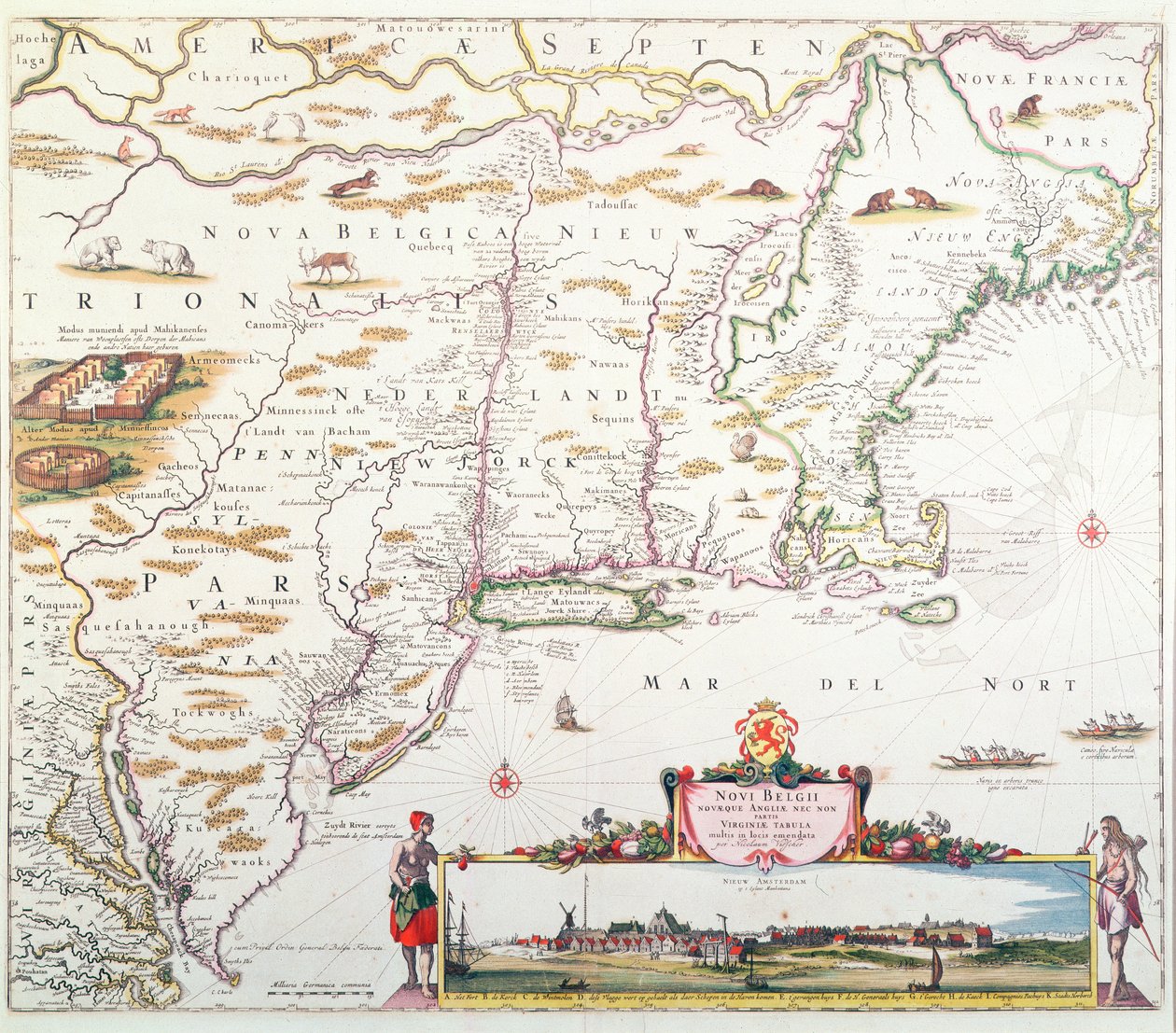
Map of New Belgium with a View of New Amsterdam, compiled by Nicolaes Visscher c.1651-55 by Joannes Jansson

Map of New Belgium with a View of New Amsterdam, compiled by Nicolaes Visscher c.1651-55

(Map of New Belgium with a View of New Amsterdam, compiled by Nicolaes Visscher (1618-1709) c.1651-55 (hand coloured engraving))


Joannes Jansson

€ 104.11
Enthält 0% MwSt.
   Configure art print
Undated  ·  hand coloured engraving  ·  Picture ID: 273432

Nonclassified artists  ·  Cartography

Map of New Belgium with a View of New Amsterdam, compiled by Nicolaes Visscher c.1651-55 by Joannes Jansson. Available as an art print on canvas, photo paper, watercolor board, uncoated paper or Japanese paper.
plan · diagram · novi belgium · new amsterdam · east coast of america · country · atlantic ocean · cartouche · Collection of the New-York Historical Society, USA / Bridgeman Images
Other color variations of this picture  
AR/3D   View in 3D / AR zu Favoriten hinzufügen   Add to favorites    Select wall color    View painting in a room
0 Reviews

Configure art print

Picture Frame

Medium & Stretcher

Glass & Passepartout

Miscellaneous & Extras

 Save / compare configuration
Preview Icon

Summary

Gemälde
Veredelung
Keilrahmen
Museumslizenz

€ 104.11
(inkl. 20% MwSt)
   Add to cart

Bildschärfe: PERFEKT

Should you desire adjustments to brightness and color, or a custom crop of the motif, we are happy to make these changes at no additional cost to you. Please do not hesitate to contact us.

Similar artworks selected for you

The Restitutio-Allardt Map of New Amsterdam, Engraved and Published by Carolus Allardt, 1673 Map of New Belgium and New England Map of New Amsterdam, c.1650 Totius Neobelgii Nova et Accuratissima Tabula, 1674 A chart of the sea coasts of New England, New Jersey, Virginia, Maryland and Carolina from Cape Cod to Cape Hatteras Pontus Euxinus Pascaart van de Noort Zee verthoonende in zich alle de Custen en havens daer rontom gelegen A Map of New England and New York from John Speed Map of Nova Belgica or New Belgium and of Anglia Nova or New England Map of Canada from The Caribbean Sea: The Bermuda Triangle between the Bermuda Archipelago, Miami, and Puerto Rico. According to Wilhelm Blaeu Map of Virginia and Florida Map of China, Japan and Korea Map of China, By Joan Blaeu Extreme northeast coastline of the States, in First of Blaeu Venezuela, Trinidad, Tobago, Tortuga, Antilles, Caribbean, in Southeast, in The Indian Subcontinent to the Philippines by Way of the Northern Portions of the Indonesian Archipelago and the Malay Peninsula The Famous West Indian Voyage Made by the English Fleet of 23 Ships and Barks A chart of the coast of America from Newfoundland to Cape Cod A chart of the sea coasts of new England, New Jersey, Virginia, Maryland and Carolina from Cape Cod to Cape Hatteras Map of Central America Map of New France dedicated to Colbert by Duchesneau, Intendant, 1681 North America
Show more similar artworks

Other art prints by Joannes Jansson

Map of New Belgium with a View of New Amsterdam, compiled by Nicolaes Visscher c.1651-55 Historical Geographical Map of Palestine. Jansson Atlas America Pars Meridionalis, page 93 of Map of the Ottoman Empire, from the Representation of the Seven Wonders of Antiquity: the Colossus of Rhodes. Atlas of Jansson Jannsonius, 1630 The Antarctic Pole Representation of the Seven Wonders of Antiquity: the Temple of Diana (Artemis) in Ephesus. Atlas of Jansson Jannsonius, 1630 Frontispiece of the Fifth Volume of Jansson Map showing the Molucca Islands off Halmahera, 1640 Sichuan and Shanxi, China Map showing the Molucca Islands off Halmahera, 1640 Representation of the Seven Wonders of Antiquity: The Mausoleum of Halicarnassus in the Atlas by Jansson Jannsonius Northeastern China New Map of Switzerland Representation of the Seven Wonders of Antiquity: The Statue of Jupiter by Phidias in
Discover more works by Joannes Jansson

Other motives from the category Cartography

Part of South Australia, from a Series of World Maps published by John Tallis und Co, New York and London Military Map of Corsica Map of Berlin and Coelln, 1688 Map of Cordoba, from New Comic Map of London Map of South America Map of the City and Portuguese Port of Goa, India (detail) A new and correct map of the world laid down according to the newest discoveries and from the most exact observations Confederate Civil War map of the Army of Mississippi camp at Corinth, Mississippi, May 1862 Map of Corsica Map of China showing the Position of the Provinces and Towns under Insurrection Map of Europe, Published in 1700, Paris Detail of Italy from the Peutinger map (detail) Map of West African coastline, 1596 World map tracing Magellan
View More from "Cartography"

Excerpt from our top sellers

The Isle of the Dead, Fifth Version, 1886 The Poor Poet Sunset Over the Lake Woman at Dawn Blooming Chestnut Tree The Garden at Giverny, 1900 The Isle of the Dead Woman with Parasol Turned to the Left, 1886 Kite Flying Fishing Boats on the Beach at Les Saintes-Maries-de-la-Mer The Beach at Saint-Clair Melencolia I Friends Schubert at the Piano Wheat Field
Show More Artworks


What our customers think about us


Frequently Asked Questions about Meisterdrucke


Personalizing your art print at Meisterdrucke is a simple and intuitive process that allows you to design an artwork exactly to your specifications: Choose a frame, determine the image size, decide on a printing medium, and add suitable glazing or a stretcher frame. We also offer customization options such as mats, fillets, and spacers. Our customer service is available to help you design your perfect artwork.

At Meisterdrucke, you have the fascinating option to visualize the artwork you configured directly in your own space. For a tailored preview, simply upload a photo of your room and let the artwork appear on it. If you visit us via a mobile device, be it a phone or tablet, our augmented reality feature brings the image to life and seamlessly projects it into your space. An experience that uniquely combines art and technology.

Choosing the medium is often a matter of personal taste. To give you a clearer idea, we have provided some images for each medium. For a holistic experience, we also offer you a sample set of all paper variants so you can make a decision not just visually but also haptically. You can take advantage of the sample set free of charge – only the shipping costs will apply. You can order the sample set directly.

Do not worry. At Meisterdrucke, we do not proceed mechanically. We manually review each order. If there are any inconsistencies or peculiarities in the configuration, we will immediately contact you. Of course, our courteous and patient support is always at your side to assist you with the configuration. Together with you, we adjust your image by phone or email so that the final result exactly meets your expectations.


Do you have any questions?

Are you interested in an art print from our manufactory but still unsure? Do you need advice on choosing the medium or help with the order?

Our experts are happy to assist you.

+43 4257 29415
support@meisterdrucke.com
Mo-Do: 7:00 - 16:00 | Fr: 7:00 - 13:00

Do you have any questions?

Are you interested in an art print from our manufactory but still unsure? Do you need advice on choosing the medium or help with the order?

Our experts are happy to assist you.

+43 4257 29415
support@meisterdrucke.com
Mo-Do: 7:00 - 16:00 | Fr: 7:00 - 13:00


Meisterdrucke

   Kärntner Strasse 46
        9586 Finkenstein am Faaker See
        Austria
        +43 4257 29415
        support@meisterdrucke.com
Other languages

                   
Erfahrungen & Bewertungen zu Meisterdrucke
Post.at DHL Express Quehenberger Cargoboard
Kaiser Franz Joseph

Meisterdrucke
Kärntner Strasse 46
9586 Finkenstein am Faaker See · Austria
+43 4257 29415 · office@meisterdrucke.com
Post.at DHL Express Quehenberger Cargoboard


Meisterdrucke 2717 Bewertungen auf ProvenExpert.com

(c) 2025 meisterdrucke.uk