support@meisterdrucke.com  ·  0043 4257 29415

Deutsch English Italiano Español Français Nederlands Português Svenska Polski Dansk
Search by artist, work title or style – e.g. Monet, Starry Night, Impressionism, Hokusai wave, nude. Describe the scene – e.g. green meadow, abstract with lots of red, dark oil painting, standing nude next to a tree.

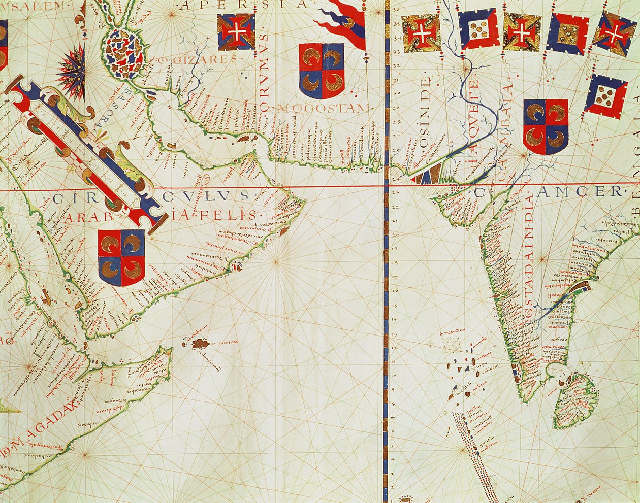
Fol. 16 Map of Persia, Arabia and India, from an atlas, 1571 by Fernao Vaz Dourado

Fol. 16 Map of Persia, Arabia and India, from an atlas, 1571

(Fol.16 Map of Persia, Arabia and India, from an atlas, 1571 )


Fernao Vaz Dourado

€ 123.19
Tax-free
   Configure art print
1571  ·  vellum  ·  Image ID: 46584

Nonclassified artists  ·  Cartography

Fol. 16 Map of Persia, Arabia and India, from an atlas, 1571 by Fernao Vaz Dourado. Available as an art print on canvas, photo paper, watercolor board, natural paper, or Japanese paper.
coastline · coat of arms · medieval · inde · arabie · middle east · renaissance · Arquivo Nacional da Torre do Tombo, Lisbon, Portugal / Bridgeman Images
AR/3D   View in 3D / AR zu Favoriten hinzufügen   Add to favorites    Change wall color    View picture in a room
0 Reviews

Configure art print

Picture Frame

Medium & Stretcher

Glass & Passepartout

Miscellaneous & Extras

 Save / compare configuration
Preview Icon

Summary

Gemälde
Veredelung
Keilrahmen
Museumslizenz

€ 123.19
(inkl. 20% MwSt)
   Add to cart

Bildschärfe: PERFEKT

If you'd like us to adjust the brightness, colors, or crop the image, we're happy to do this for you at no extra cost. Just get in touch!

Similar artworks selected for you

Fol. 13 Map of South America and the Magellan Straits, from an atlas, 1571 Map of the Atlantic Ocean, c. 1550 Portolan chart of the Atlantic Ocean, Mediterranean and Black Sea, c.1535 Chart of the Atlantic Ocean, Mediterranean and Black Sea, c.1535 Plane-Chart, Pre-Mercator Map of 1571 by the Portuguese Cartographer Fernao Vaz Dourado. Map of East India, Bay of Bengal, South East China, Thailand, Borneo, and Japan. The Tropic of Cancer is Named. Portulan: Geographic Map with the Name of the Coastline of Cuba, Florida, Central America and North Latin America Portolan Chart of Western Europe and North Africa Map of South America. Portulan by Bartolomeo Velhio Planisphere of Cantino: Map of Alberto Cantino from 1502 representing the boundary line imposed by the Treaty of Tordesillas (1494) between Portuguese and Spanish America. Biblioteca Estense, Modena Chart of Arabia and the Eastern Mediterranean, Part of a Portolan Atlas, c.1650 Detail of a map of Labrador (Markland), Eastern Canada (detail) The Indian Ocean, from an Atlas of the World in 33 Maps, Venice, 1st September 1553 Madagascar and East African Coastline, detail from a world atlas, 1565 The French Coast, England, Scotland and Ireland, from a nautical atlas (detail) Map of Europe, from a facsimile of the ‘Miller Atlas’ by Pedro and Jorge Reinel, and Lopo Homem, made in 1519 The Eastern Mediterranean, from a nautical atlas, 1520 Illustration from the Queen Mary Atlas Fol. 5v Map of Great Britain, Europe and North West Africa, from Portugaliae Monumenta Cartographica, an account of the discoveries of Fernão Gomes from 1470-75, 1563 Caribbean and Coasts of America Provence and Italy, from a nautical atlas, 1520 (detail from 330915) Atlantic Ocean, 5 degrees south to 57 degrees north Portulan representing South America belonging to Bartolomeo Velho, 1561 Sicily from portolan atlas consisting of six charts, Parchment. 1646 Nautical Chart of Mediterranean Area, Including Europe with British Isles and Part of Scandinavia Chart of North-East Atlantic, from British Isles to Cape Verde Route of Drake A Mediterranean Chart Showing the North East Atlantic Islands of Central America, nautical chart by Juan de la Cosa Chart of the Eastern Mediterranean, c.1600
Show more similar artworks

Similar artworks selected for you

Fol. 13 Map of South America and the Magellan Straits, from an atlas, 1571 Map of the Atlantic Ocean, c. 1550 Portolan chart of the Atlantic Ocean, Mediterranean and Black Sea, c.1535 Chart of the Atlantic Ocean, Mediterranean and Black Sea, c.1535 Plane-Chart, Pre-Mercator Map of 1571 by the Portuguese Cartographer Fernao Vaz Dourado. Map of East India, Bay of Bengal, South East China, Thailand, Borneo, and Japan. The Tropic of Cancer is Named. Portulan: Geographic Map with the Name of the Coastline of Cuba, Florida, Central America and North Latin America Portolan Chart of Western Europe and North Africa Map of South America. Portulan by Bartolomeo Velhio Planisphere of Cantino: Map of Alberto Cantino from 1502 representing the boundary line imposed by the Treaty of Tordesillas (1494) between Portuguese and Spanish America. Biblioteca Estense, Modena Chart of Arabia and the Eastern Mediterranean, Part of a Portolan Atlas, c.1650 Detail of a map of Labrador (Markland), Eastern Canada (detail) The Indian Ocean, from an Atlas of the World in 33 Maps, Venice, 1st September 1553 Madagascar and East African Coastline, detail from a world atlas, 1565 The French Coast, England, Scotland and Ireland, from a nautical atlas (detail) Map of Europe, from a facsimile of the ‘Miller Atlas’ by Pedro and Jorge Reinel, and Lopo Homem, made in 1519 The Eastern Mediterranean, from a nautical atlas, 1520 Illustration from the Queen Mary Atlas Fol. 5v Map of Great Britain, Europe and North West Africa, from Portugaliae Monumenta Cartographica, an account of the discoveries of Fernão Gomes from 1470-75, 1563 Caribbean and Coasts of America Provence and Italy, from a nautical atlas, 1520 (detail from 330915) Atlantic Ocean, 5 degrees south to 57 degrees north Portulan representing South America belonging to Bartolomeo Velho, 1561 Sicily from portolan atlas consisting of six charts, Parchment. 1646 Nautical Chart of Mediterranean Area, Including Europe with British Isles and Part of Scandinavia Chart of North-East Atlantic, from British Isles to Cape Verde Route of Drake A Mediterranean Chart Showing the North East Atlantic Islands of Central America, nautical chart by Juan de la Cosa Chart of the Eastern Mediterranean, c.1600
Show more similar artworks

More motifs from the category Cartography

A Map of Moorfields and Hoxton, London, 1746 Ms. Ital. 550.0.3.15, fol. 4v-5r. Map of the Eastern Mediterranean Coast and Islands, from the „Carte Geografiche“ Inc. 425 Map of the Holy Land, based on descriptions and co-ordinates given in Cosmographica, by Ptolemy (Claudius Ptolemaeus of Alexandria) (c. 90-168 AD), published in Ulm, Germany, by Johann Reger fo Renaissance map of Europe, Jacopo Russo (after), 1528 Map of Cumberland Map of the Suez Canal accompanied by different views and portraits of Ferdinand de Lesseps (1805-94) and Ismail Pasha (1830-95), 1869 Map of Africa, from Nova Africa Descriptio, published in Amsterdam in the 1660s by Dutch cartographer Frederik de Wit Sketch map of Africa, from Ms. 986, Vol. 1, Plan and Map of Cambrai, from the “Atlas Louis XIV”, 1683-88 Map of Paris showing Île de la Cité, from L’Atlas de Paris by Jean de la Caille, 1714 Map of Raab, from Civitates Orbis Terrarum by Georg Braun (1541-1622) and Frans Hogenberg (1535-90), 1597 Map of Siberia and China from Le Théâtre du Monde or Nouvel Atlas, 1645 Map of Florence, 1843 and 1866 (for detail see 100311) Map of Vienna, published by Klimsch und Co., Frankfurt, c. 1860 Map of Rostock, from ’Civitates Orbis Terrarum’ by Georg Braun (1541-1622) and Frans Hogenberg (1535-90), c. 1572-1617
View More from "Cartography"

More motifs from the category Cartography

A Map of Moorfields and Hoxton, London, 1746 Ms. Ital. 550.0.3.15, fol. 4v-5r. Map of the Eastern Mediterranean Coast and Islands, from the „Carte Geografiche“ Inc. 425 Map of the Holy Land, based on descriptions and co-ordinates given in Cosmographica, by Ptolemy (Claudius Ptolemaeus of Alexandria) (c. 90-168 AD), published in Ulm, Germany, by Johann Reger fo Renaissance map of Europe, Jacopo Russo (after), 1528 Map of Cumberland Map of the Suez Canal accompanied by different views and portraits of Ferdinand de Lesseps (1805-94) and Ismail Pasha (1830-95), 1869 Map of Africa, from Nova Africa Descriptio, published in Amsterdam in the 1660s by Dutch cartographer Frederik de Wit Sketch map of Africa, from Ms. 986, Vol. 1, Plan and Map of Cambrai, from the “Atlas Louis XIV”, 1683-88 Map of Paris showing Île de la Cité, from L’Atlas de Paris by Jean de la Caille, 1714 Map of Raab, from Civitates Orbis Terrarum by Georg Braun (1541-1622) and Frans Hogenberg (1535-90), 1597 Map of Siberia and China from Le Théâtre du Monde or Nouvel Atlas, 1645 Map of Florence, 1843 and 1866 (for detail see 100311) Map of Vienna, published by Klimsch und Co., Frankfurt, c. 1860 Map of Rostock, from ’Civitates Orbis Terrarum’ by Georg Braun (1541-1622) and Frans Hogenberg (1535-90), c. 1572-1617
View More from "Cartography"

A selection of our top sellers

The Kiss Arab Café (Little Turk) The Apple Harvest The Dream of the Fisherman Three Sunflowers The Sun Fast Sinks in the West Hylas and the Water Nymphs Madonna and Child with Two Angels Boy Writing with His Sister, 1875 Aeneas and the Cumaean Sibyl View of Florence, 1837. Christ in the Wilderness The Night Watch Kanchenjunga, 1936 Wheatfield
Show more artworks

A selection of our top sellers

The Kiss Arab Café (Little Turk) The Apple Harvest The Dream of the Fisherman Three Sunflowers The Sun Fast Sinks in the West Hylas and the Water Nymphs Madonna and Child with Two Angels Boy Writing with His Sister, 1875 Aeneas and the Cumaean Sibyl View of Florence, 1837. Christ in the Wilderness The Night Watch Kanchenjunga, 1936 Wheatfield
Show more artworks


What our customers think about us


Frequently Asked Questions about Meisterdrucke


Personalizing your art print at Meisterdrucke is simple and intuitive: Choose a frame, set the image size, pick a printing medium, and add suitable glazing or a stretcher frame. We also offer additional customization options like mats, fillets, and spacers. If you have any questions, our customer service team is ready to help you create your perfect artwork.

At Meisterdrucke, you can visualize your configured artwork directly in your own room. Simply upload a photo of your space and see how the artwork looks in it. If you're visiting us on a mobile device — phone or tablet — our augmented reality feature brings the picture to life and projects it right into your room. A unique experience that combines art and technology.

Choosing the right medium is often a matter of personal taste. To give you a better idea, we've provided some images for each medium. We also offer a sample set of all paper variants, so you can decide not just visually but by touch as well. You can order the sample set free of charge — only shipping costs apply.

Don't worry! At Meisterdrucke, we don't just process orders mechanically. Every order is manually reviewed by our team. If we spot any inconsistencies or issues with your configuration, we'll get in touch with you right away. And of course, our friendly and patient support team is always here to help you with your configuration. We'll work with you by phone or email to adjust your image so the final result is exactly what you had in mind.


Still have questions?

Are you interested in an art print from our manufactory but still unsure? Do you need advice on choosing the medium or help with the order?

Our experts are happy to assist you.

+43 4257 29415
support@meisterdrucke.com
Mo-Do: 7:00 - 16:00 | Fr: 7:00 - 13:00

Still have questions?

Are you interested in an art print from our manufactory but still unsure? Do you need advice on choosing the medium or help with the order?

Our experts are happy to assist you.

+43 4257 29415
support@meisterdrucke.com
Mo-Do: 7:00 - 16:00 | Fr: 7:00 - 13:00


Meisterdrucke

   Kärntner Strasse 46
        9586 Finkenstein am Faaker See
        Austria
        +43 4257 29415
        support@meisterdrucke.com
Other languages

                   
Erfahrungen & Bewertungen zu Meisterdrucke
Post.at DHL Express Quehenberger Cargoboard
Kaiser Franz Joseph

Meisterdrucke
Kärntner Strasse 46
9586 Finkenstein am Faaker See · Austria
+43 4257 29415 · support@meisterdrucke.com
Post.at DHL Express Quehenberger Cargoboard


(c) 2026 meisterdrucke.uk