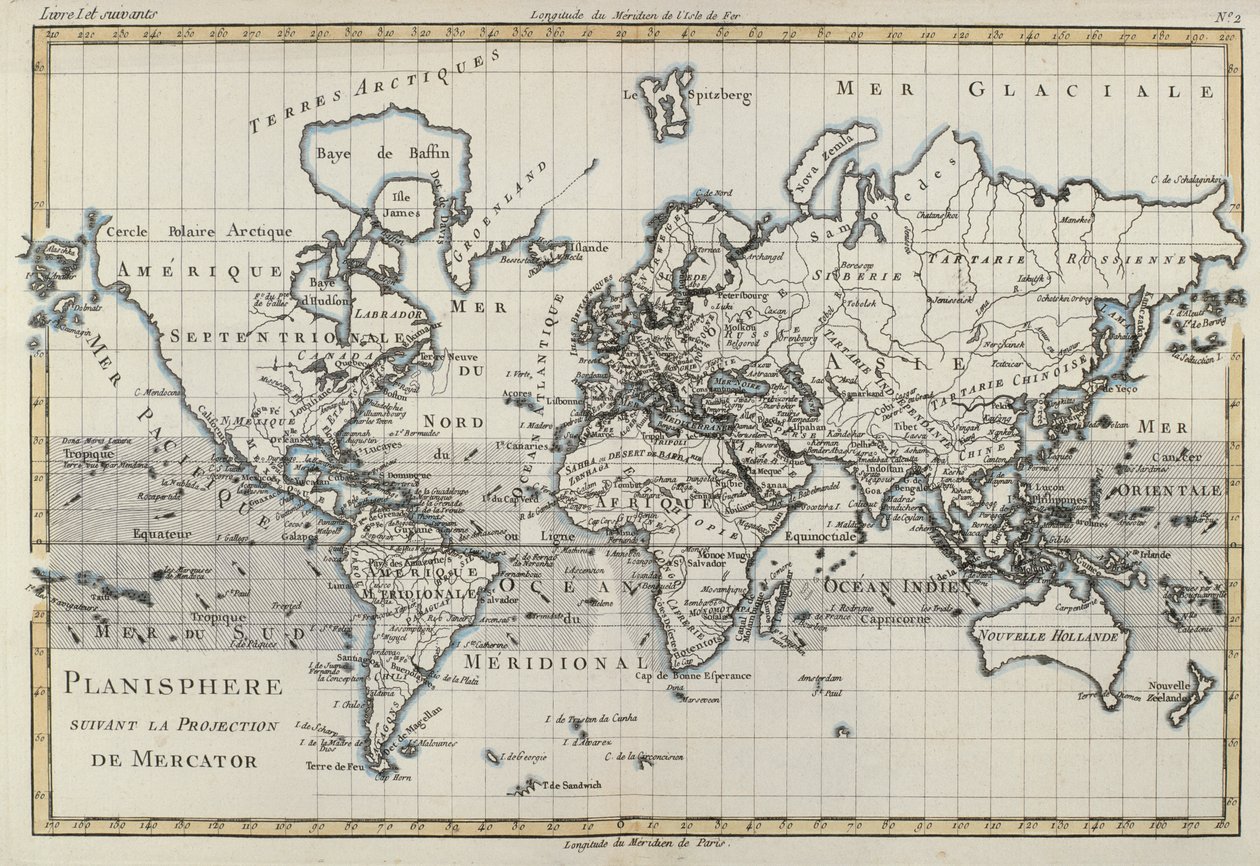
Map of the World using the Mercator Projection, from

Map of the World using the Mercator Projection, from 'Atlas de Toutes les Parties Connues du Globe Terrestre' by Guillaume Raynal (1713-96) published Geneva, 1780

(Map of the World using the Mercator Projection, from 'Atlas de Toutes les Parties Connues du Globe Terrestre' by Guillaume Raynal (1713-96) published Geneva, 1780 )


Charles Marie Rigobert Bonne

€ 124.38
Enthält 0% MwSt.
   Configure art print
1780  ·  coloured engraving  ·  Picture ID: 65565

Nonclassified artists  ·  Cartography

Map of the World using the Mercator Projection, from 'Atlas de Toutes les Parties Connues du Globe Terrestre' by Guillaume Raynal (1713-96) published Geneva, 1780 by Charles Marie Rigobert Bonne. Available as an art print on canvas, photo paper, watercolor board, uncoated paper or Japanese paper.
continent · ocean · Private Collection / Bridgeman Images
Other color variations of this picture  
AR/3D   View in 3D / AR zu Favoriten hinzufügen   Add to favorites    Select wall color    View painting in a room
0 Reviews

Configure art print

Picture Frame

Medium & Stretcher

Glass & Passepartout

Miscellaneous & Extras

 Save / compare configuration
Preview Icon

Summary

Gemälde
Veredelung
Keilrahmen
Museumslizenz

€ 124.38
(inkl. 20% MwSt)
   Add to cart

Bildschärfe: PERFEKT

Should you desire adjustments to brightness and color, or a custom crop of the motif, we are happy to make these changes at no additional cost to you. Please do not hesitate to contact us.

Similar artworks selected for you

Map of the World Illustration from the book Investigations on the Magnetism of the Earth by Hansteen, Christopher and published by C. Hansteen (Christiania, 1819) Map of the world, Italy, mid 19th century Map showing the world trade shipping routes, cartography by Pierre Duval published in 1686, Paris A New and Correct Map of the World from an Atlas of the Sea, 1707 (hand coloured print) The World According to Mercator A general chart on Mercator Chart Plotting the Routes from France and Spain, of the Outward and Return Voyages to the West Indies and East Indies, with Branches for Different Destinations The World, image taken from page 17 of The World as known to the Ancients, showing the Dispersion and Supposed Settling of the Descendants of Noah Map of the World, 1780 A general chart for the purpose of picking off a ship Map World map, Totius Orbis cognier universalis descriptio The World on Mercator World Map and a General Description of the Globe, Engraving by G. Zuliani from the Newest Atlas A New Map of the World in Two Hemispheres with the New Discoveries & Tracts of the Two Circum Navigators Dampier & Anson A General Chart Exhibiting the Discoveries Made by Captain James Cook Map of the World in two Hemispheres, from A Map of the World, Corrected from the Observations Communicated to the Royal Societies of London and Paris, to the Right Honourable Richard Boyle General Map of the Earth A new and correct map of the world laid down according to the newest discoveries and from the most exact observations A General Chart Exhibiting the Discoveries Made by Captain James Cook in This and His Two Preceding Voyages with the Tracks of the Ships Under His Command. By Lieutenant Roberts of His Majesty Map of Africa Geo-Hydrographic Mappamonde World Map, Drawn from Observations of the Royal Academy of Sciences and Others Map of the Whole World - Adorned According to the Observations of the Royal Academy of Sciences and Some Others According to the Latest Annotations A New and Correct Map of the World, Laid Down According to the Newest Discoveries, and from the Most Exact Observations, by Herman Moll, Geographer
Show more similar artworks

Other art prints by Charles Marie Rigobert Bonne

Map of the World using the Mercator Projection, from Map of Independent Tartary Including the Lands of the Kalmyks, Uzbeks, and Turkestan Map of the World in two Hemispheres, from West Coast of Africa, from Lisbon to Sierra Leone, from Arabia, the Persian Gulf and the Red Sea, with Egypt, Nubia and Abyssinia, from The French and Spanish Colony of the Island of St Dominic of the Greater Antilles, from The Lesser Antilles or the Windward Islands, with the Eastern Part of the Leeward Islands, from Map of the Russian Empire, in Europe and Asia, from The Island of Martinique, from The Chinese Empire, Chinese Tartary and the Kingdom of Korea, with the Islands of Japan, from Atlas de Toutes les Parties Connues du Globe Terrestre by Guillaume Raynal (1713-96) Published 1780 North Africa, Including the Kingdoms of Tripoli, Tunis, Alger; Fez and Morocco, from Atlas de Toutes les Parties Connues du Globe Terrestre by Guillaume Raynal (1713-96) Published Geneva, 1780 The Philippines, Formosa, South China, the Kingdoms of Tonkin, Cochin China, Cambodia, Siam, Laos, and Part of Those of Pegu and Ava Northern India, from Holland Including the Seven United Provinces of the Low Countries, from Western Canada, Including the Five Great Lakes, from
Discover more works by Charles Marie Rigobert Bonne

Other motives from the category Cartography

Map of Europe, Published in 1700, Paris Map of Sixteenth Century France, from the Map and fortifications of Neuf-Brisach Map of the United States in 1861, from Map of the Gujarat state of India, published under the direction of Colonel J.T. Walker, Surveyor General of India La Naptune Francois, ou Atlas des Cartes Marines, 1693 Map of Charleston, South Carolina, 3 August 1781 Battle of Waterloo, Map of the Battlefield, Engraved by Jacowick, 1816 Map of Cambridge, from Caius Map of Massachusetts, from Map of Tenochtitlan and the Gulf of Mexico, from Praeclara Ferdinadi Cortesii de Nova maris Oceani Hyspania Narratio by Hernando Cortes (1485-1547) 1524 Map of the city of Rome, engraved by the artist, 1557 Map of South America Map of Europe, from a Facsimile of the A New and Accurate Map of the World
View More from "Cartography"

Excerpt from our top sellers

Wheatfield with Cypresses The Isle of the Dead Appian Way The Course of Empire: Desolation The Art of Painting Cartoon: Series Judith with the Head of Holofernes White Waterlilies The Japanese Footbridge and the Water Lily Pool, Giverny Dining Room on the Garden, 1934-35 Anguish The Last Supper The Quiet River, 1913 The Destruction of Herculaneum and Pompeii Malcesine on Lake Garda
Show More Artworks


What our customers think about us


Frequently Asked Questions about Meisterdrucke


Personalizing your art print at Meisterdrucke is a simple and intuitive process that allows you to design an artwork exactly to your specifications: Choose a frame, determine the image size, decide on a printing medium, and add suitable glazing or a stretcher frame. We also offer customization options such as mats, fillets, and spacers. Our customer service is available to help you design your perfect artwork.

At Meisterdrucke, you have the fascinating option to visualize the artwork you configured directly in your own space. For a tailored preview, simply upload a photo of your room and let the artwork appear on it. If you visit us via a mobile device, be it a phone or tablet, our augmented reality feature brings the image to life and seamlessly projects it into your space. An experience that uniquely combines art and technology.

Choosing the medium is often a matter of personal taste. To give you a clearer idea, we have provided some images for each medium. For a holistic experience, we also offer you a sample set of all paper variants so you can make a decision not just visually but also haptically. You can take advantage of the sample set free of charge – only the shipping costs will apply. You can order the sample set directly.

Do not worry. At Meisterdrucke, we do not proceed mechanically. We manually review each order. If there are any inconsistencies or peculiarities in the configuration, we will immediately contact you. Of course, our courteous and patient support is always at your side to assist you with the configuration. Together with you, we adjust your image by phone or email so that the final result exactly meets your expectations.


Do you have any questions?

Are you interested in an art print from our manufactory but still unsure? Do you need advice on choosing the medium or help with the order?

Our experts are happy to assist you.

+43 4257 29415
support@meisterdrucke.com
Mo-Do: 7:00 - 16:00 | Fr: 7:00 - 13:00

Do you have any questions?

Are you interested in an art print from our manufactory but still unsure? Do you need advice on choosing the medium or help with the order?

Our experts are happy to assist you.

+43 4257 29415
support@meisterdrucke.com
Mo-Do: 7:00 - 16:00 | Fr: 7:00 - 13:00


Meisterdrucke

   Kärntner Strasse 46
        9586 Finkenstein am Faaker See
        Austria
        +43 4257 29415
        support@meisterdrucke.com
Other languages

                   
Erfahrungen & Bewertungen zu Meisterdrucke
Post.at DHL Express Quehenberger Cargoboard
Kaiser Franz Joseph

Meisterdrucke
Kärntner Strasse 46
9586 Finkenstein am Faaker See · Austria
+43 4257 29415 · office@meisterdrucke.com
Post.at DHL Express Quehenberger Cargoboard


Meisterdrucke 2705 Bewertungen auf ProvenExpert.com

(c) 2025 meisterdrucke.uk