Search by artist, work title or style – e.g. Monet, Starry Night, Impressionism, Hokusai wave, nude. Describe the scene – e.g. green meadow, abstract with lots of red, dark oil painting, standing nude next to a tree.

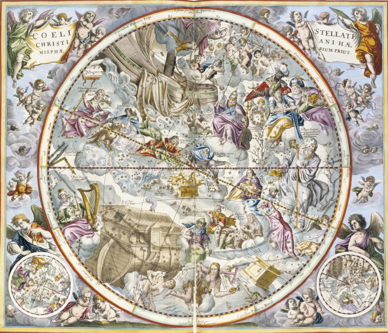
Map of the Christian Constellations as Depicted by Julius Schiller, from The Celestial Atlas by Andreas Cellarius

Map of the Christian Constellations as Depicted by Julius Schiller, from The Celestial Atlas

(Map of the Christian Constellations as Depicted by Julius Schiller, from The Celestial Atlas, or The Harmony of the Universe atlas coelestis seu harmonia macrocosmica pub. by Joannes Janssonius, Amste)


Andreas Cellarius

€ 108.7
Enthält 0% MwSt.
   Configure art print
Undated  ·  hand coloured engraving  ·  Picture ID: 355421

Nonclassified artists  ·  Cartography

Map of the Christian Constellations as Depicted by Julius Schiller, from The Celestial Atlas by Andreas Cellarius. Available as an art print on canvas, photo paper, watercolor board, uncoated paper or Japanese paper.
constellation · star chart · noah · religious · Private Collection / Bridgeman Images
Other color variations of this picture  
AR/3D   View in 3D / AR zu Favoriten hinzufügen   Add to favorites    Select wall color    View painting in a room
0 Reviews

Configure art print

Picture Frame

Medium & Stretcher

Glass & Passepartout

Miscellaneous & Extras

 Save / compare configuration
Preview Icon

Summary

Gemälde
Veredelung
Keilrahmen
Museumslizenz

€ 108.7
(inkl. 20% MwSt)
   Add to cart

Bildschärfe: PERFEKT

Should you desire adjustments to brightness and color, or a custom crop of the motif, we are happy to make these changes at no additional cost to you. Please do not hesitate to contact us.

Similar artworks selected for you

1660 celestial chart representing the constellations according to Christian symbolism 1660 celestial map of constellations according to Christian symbolism Celestial Planisphere Showing the Signs of the Zodiac, from Map of the Sky and Signs of the Zodiac (Facsimile of an Ancient Composition Representing the Constellations of the Northern Sky, Based on André Cellarius Constellations of the Southern Hemisphere, from Southern Hemisphere Constellations Scenographically over the Terrestrial Globe Representation of the Southern Hemisphere by Cellarius. 17th century book. Atlas Coelestis seu Harmonia Macrocosmica. 1661. Fol 24. Hemisphaerium stellatum boreale antiquum. Representation of the Northern Hemisphere. Printed in Amsterdam by Johannes Janssonius. Early Modern Era Celestial Planisphere Showing the Signs of the Zodiac Stars and signs of the zodiac Phillips, 4274 Phillips, 4274 Celestial Planisphere: Northern Hemisphere 1660 Celestial Chart of the Northern Sky Northern Hemisphere of the Sky with Fixed Stars Locations According to the Ecliptic Path for the Year 1730 Map of the sky and signs of the zodiac - facsimile of an ancient composition representing the constellations of the southern sky, according to Celestial Map Illustrating the Constellations of the Northern Hemisphere (1660) Celestial Map of the Constellations of the Southern Hemisphere (1660) Northern (Boreal) Hemisphere, from Northern (Boreal) Hemisphere, from Phillips, 4274 Available also through the Library of Congress Web site as a raster image. Includes index. Some plates engraved by Johannes van Loon. In addition to the 29 plates specified in the table of contents, there is an additional plate between plate Part of a Southern Hemisphere Star Chart from Reiner Ottens 1661 Celestial Map of the Southern Sky 1660 Celestial Map Ancient Southern Starry Hemisphere Map of the Southern Hemisphere, from Map of the celestial Southern Hemisphere
Show more similar artworks

Other art prints by Andreas Cellarius

Map of the Southern Hemisphere, from The Situation of the Earth in the Heavens, Plate 74 from Map showing Tycho Brahe Phases of the Moon, from Scenographia: Systematis Copernicani Astrological Chart (c.1543) devised by Nicolaus Copernicus (1473-1543), from Nicolaus Copernicus, Detail from a Map Showing the Copernican System of Planetary Orbits, Planetary orbits, plate 18 from Map of the celestial Southern Hemisphere Harmonia Macrocosmica, Ptolemaic theory of planetary motion, engraving, by Andreas Cellarius Representation of the Copernican System of the Universe with the Movements of the Earth in Relation to the Sun Map of the Christian Constellations as Depicted by Julius Schiller, from Map Showing Tycho Brahe 1660 Illustration of Claudius Ptolemy Map of the Constellations of the Northern Hemisphere, from The Copernican System,
Discover more works by Andreas Cellarius

Other motives from the category Cartography

Detail of the Left Bank, from the Map of Paris c. 1540, known as the Plan de la Tapisserie, made as a Tapestry c. 1570 Part of the Tabula Peutingeriana, an illustrated itinerarium of the road network in the Roman Empire. Detail of Italy from the Peutinger map copy Map of Africa, Published in 1700, Paris Map of London in the Time of the Romans West Coast of Africa, from Lisbon to Sierra Leone, from Map of Great Britain, Europe and North West Africa, from Portugaliae Monumenta Cartographica, an Account of the Discoveries of Fernao Gomez from 1470-75 Map Showing the Principal Stars Visible in Great Britain (Plate XXIX), from Map of the Mediterranean, 1625 Map of America, from the Mercator Atlas, published by Jodocus Hondius, Amsterdam, 1606 Map of Africa Photograph of a French Map Showing the Battlefields of Verdun, September 1916 Map No.6 showing the route of the Armada fleet, engraved by Augustine Ryther, 1588 Map of North West-Point, Virginia, from Galathes, 11th King of the Gauls with a map of Gaul behind, detail from a tapestry on the history of the Kings of the Gauls, Arras Workshop, c.1530 Map of the World, designed by Sebastien Cabot (c.1476-1557), 1544
View More from "Cartography"

Excerpt from our top sellers

The Tower of Babel (Rotterdam) Sower at Sunset View of Houses in Delft, known as The Little Street Among the Sierra Nevada, California Tierfabel: Tiger and Snake in Combat in a Primeval Forest Kingfisher by the Waterside The Milkmaid Woman in Tehuantepec, Mexico Ghost of a Genius The Artist Three White Cottages in Saintes-Maries The Taking of Christ Autumn Landscape with Boats Dance from the series The Arts Composition VII
Show More Artworks


What our customers think about us


Frequently Asked Questions about Meisterdrucke


Personalizing your art print at Meisterdrucke is a simple and intuitive process that allows you to design an artwork exactly to your specifications: Choose a frame, determine the image size, decide on a printing medium, and add suitable glazing or a stretcher frame. We also offer customization options such as mats, fillets, and spacers. Our customer service is available to help you design your perfect artwork.

At Meisterdrucke, you have the fascinating option to visualize the artwork you configured directly in your own space. For a tailored preview, simply upload a photo of your room and let the artwork appear on it. If you visit us via a mobile device, be it a phone or tablet, our augmented reality feature brings the image to life and seamlessly projects it into your space. An experience that uniquely combines art and technology.

Choosing the medium is often a matter of personal taste. To give you a clearer idea, we have provided some images for each medium. For a holistic experience, we also offer you a sample set of all paper variants so you can make a decision not just visually but also haptically. You can take advantage of the sample set free of charge – only the shipping costs will apply. You can order the sample set directly.

Do not worry. At Meisterdrucke, we do not proceed mechanically. We manually review each order. If there are any inconsistencies or peculiarities in the configuration, we will immediately contact you. Of course, our courteous and patient support is always at your side to assist you with the configuration. Together with you, we adjust your image by phone or email so that the final result exactly meets your expectations.


Do you have any questions?

Are you interested in an art print from our manufactory but still unsure? Do you need advice on choosing the medium or help with the order?

Our experts are happy to assist you.

+43 4257 29415
support@meisterdrucke.com
Mo-Do: 7:00 - 16:00 | Fr: 7:00 - 13:00

Do you have any questions?

Are you interested in an art print from our manufactory but still unsure? Do you need advice on choosing the medium or help with the order?

Our experts are happy to assist you.

+43 4257 29415
support@meisterdrucke.com
Mo-Do: 7:00 - 16:00 | Fr: 7:00 - 13:00


Meisterdrucke

   Kärntner Strasse 46
        9586 Finkenstein am Faaker See
        Austria
        +43 4257 29415
        support@meisterdrucke.com
Other languages

                   
Erfahrungen & Bewertungen zu Meisterdrucke
Post.at DHL Express Quehenberger Cargoboard
Kaiser Franz Joseph

Meisterdrucke
Kärntner Strasse 46
9586 Finkenstein am Faaker See · Austria
+43 4257 29415 · office@meisterdrucke.com
Post.at DHL Express Quehenberger Cargoboard


Meisterdrucke 2764 Bewertungen auf ProvenExpert.com

(c) 2025 meisterdrucke.uk