Search by artist, work title or style – e.g. Monet, Starry Night, Impressionism, Hokusai wave, nude. Describe the scene – e.g. green meadow, abstract with lots of red, dark oil painting, standing nude next to a tree.

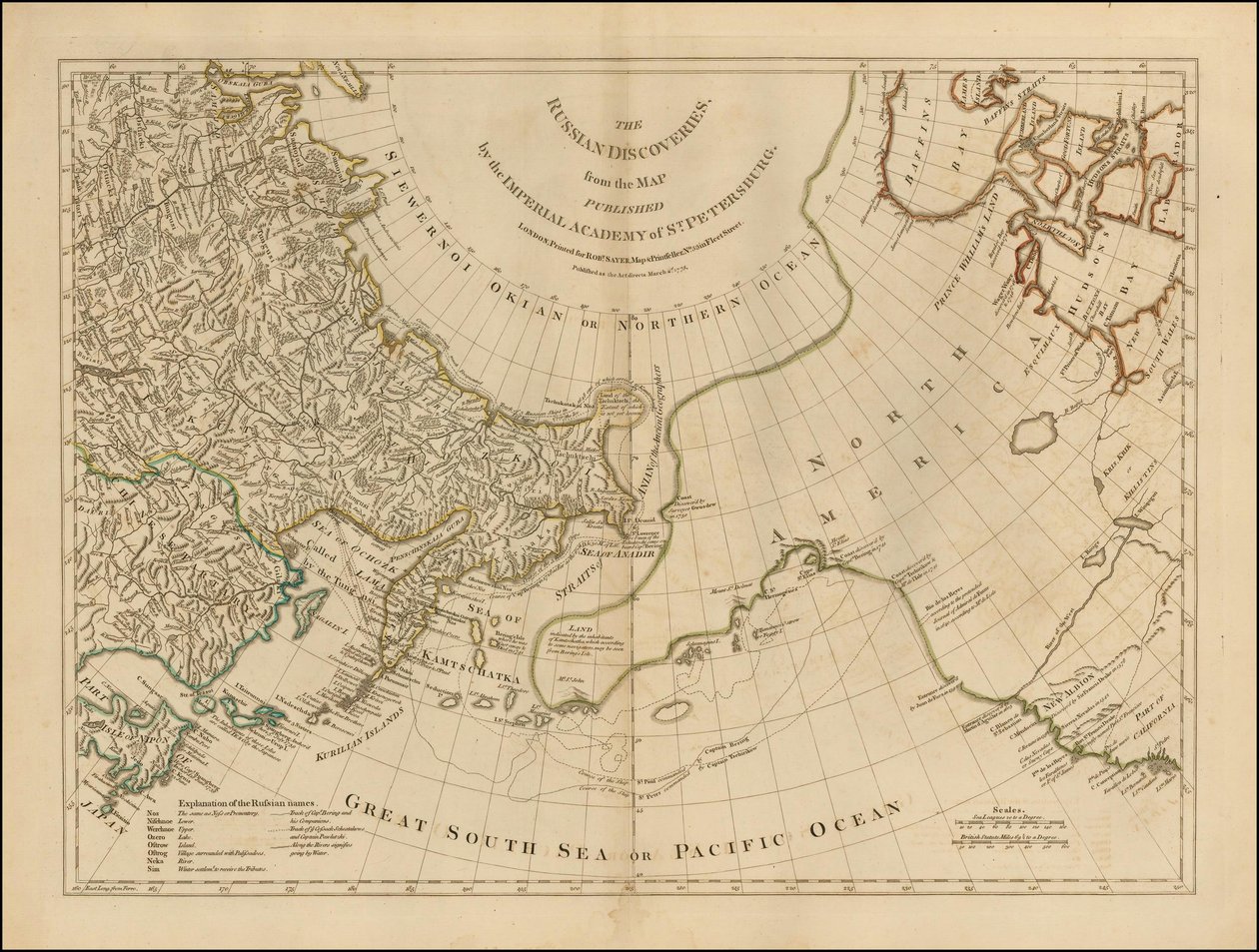
1775 Map - The Russian Discoveries, from the Map Published by the Imperial Academy of St. Petersburg by Robert Sayer

1775 Map - The Russian Discoveries, from the Map Published by the Imperial Academy of St. Petersburg

(1775 map - The Russian Discoveries, from the Map Published by the Imperial Academy of St. Petersburg)


Robert Sayer

€ 104.5
Enthält 0% MwSt.
   Configure art print
1775  ·  Picture ID: 1562646

Nonclassified artists

1775 Map - The Russian Discoveries, from the Map Published by the Imperial Academy of St. Petersburg by Robert Sayer. Available as an art print on canvas, photo paper, watercolor board, uncoated paper or Japanese paper.
AR/3D   View in 3D / AR zu Favoriten hinzufügen   Add to favorites    Select wall color    View painting in a room
0 Reviews

Configure art print

Picture Frame

Medium & Stretcher

Glass & Passepartout

Miscellaneous & Extras

 Save / compare configuration
Preview Icon

Summary

Gemälde
Veredelung
Keilrahmen
Museumslizenz

€ 104.5
(inkl. 20% MwSt)
   Add to cart

Bildschärfe: PERFEKT

Should you desire adjustments to brightness and color, or a custom crop of the motif, we are happy to make these changes at no additional cost to you. Please do not hesitate to contact us.

Similar artworks selected for you

Finland and Russia, from Europe, describing all the changes of Territory, together with their deviations in the boundary lines of its several Empires and States agreed to and confirmed by the definitive treaty of Paris, 20th Nov. 1815, published 1816 A Chart of the Northern Pacific Ocean Containing the NE Coast of Asia & NW Coast of America Explored in 1778 & 1779 by Captain Cook and Further Explored in 1788 & 1789 by John Meares Map of the New Discoveries to the North of the South Seas, 1750 Map of the Russian Empire, in Europe and Asia, from An Account of the New Northern Archipelago Lately Discovered by the Russians Hudson Bay, Land of Labrador and Greenland, engraving by G. Zuliani from The Chinese Empire, Chinese Tartary and the Kingdom of Korea, with the Islands of Japan, from Atlas de Toutes les Parties Connues du Globe Terrestre by Guillaume Raynal (1713-96) Published 1780 Cook Asia, from Northern Europe, Including Denmark, Norway, Sweden and Lapland, with Most of Western Russia, from Atlas de Toutes les Parties Connues du Globe Terrestre by Guillaume Raynal (1713-96) Published Geneva Map of Russia in the 18th Century in Latin, by Ivan Kurilov To the officers in the honourable East India Company World Known to the Ancients, engraving by G. Zuliani taken from Tome IV of the Newest Atlas published in Venice in 1785 by Antonio Zatta, Private Collection A Special Map of the Port of Boston with Soundings, Sandbanks, Rocks, and Other Useful Directions for Navigation The Atlantic or Western Ocean from the West-India Atlas, 1775 Frontispiece map from World map displaying the tracks of Captain Cook 1776 Map - New Discoveries of the Russians in the North of the South Sea in Asia and America The World as Known to the Ancients Showing the Dispersion and Supposed Settling of the Descendants of Noah A General Chart Exhibiting the Discoveries Made by Captain James Cook in This and His Two Preceding Voyages with the Tracks of the Ships Under His Command. By Lieutenant Roberts of His Majesty North America, from A Chart of the Atlantic or Western Ocean, showing the track of Nelson Map Hydrographical Chart of the Arctic Regions The North Part of America: conteyning Newfoundland, New England, Virginia, by Henry Briggs Chart showing discoveries of Ross, Parry and Franklin in the Arctic during 1818-1827 Chart of the Atlantic Ocean, with the British, French & Spanish settlements in North America and the West Indies Composite World Atlas by William Faden A Map of the British and French Dominions in America
Show more similar artworks

Other art prints by Robert Sayer

A Front View of the Royal Palace of Kensington (London) View of Kensington Palace in London (series title: London) View of Hampton Court Palace in London (London) The city of Batavia in the island of Java and capital of all the Dutch factories & settlements in the East Indies Eight Beautiful Groups of Natural Flowers in Outlines by de la Cour: Tulips A new and accurate chart of the Baltic or East Sea showing the islands, rocks and shoals with their marks, light-houses, soundings and sailing channels A general chart of the islands of Guernsey and Jersey, Sark, Herm, Jethou and Alderney, with Cape la Hague and the Caskets 1775 Map - The Russian Discoveries, from the Map Published by the Imperial Academy of St. Petersburg A Plan of London, Westminster and Southwark View of Greenwich Hospital on the River Thames in Greenwich View of a Lane in Vauxhall Gardens, London (Ranelagh Gardens and Vauxhall Gardens) Going into the Port of Flushing View of the Interior of Saint Paul View of the City of London View of the Temple of Comus in Vauxhall Gardens, London
Discover more works by Robert Sayer

Excerpt from our top sellers

In the Grey View of Vétheuil. 1880 A Young Girl Defending Herself against Eros Elizabeth of Bavaria (1837-98), Empress of Austria, Wife of Emperor Franz Joseph of Austria (1830-1916) Madonna with Child and Two Angels Silent Night The Seven Works of Mercy Mars and Venus, Allegory of Peace Reclining Nude View of Florence The Open Window Quai du Louvre Coffee Garden at Ammersee Iron Rolling Mill Water Lilies
Show More Artworks


What our customers think about us


Frequently Asked Questions about Meisterdrucke


Personalizing your art print at Meisterdrucke is a simple and intuitive process that allows you to design an artwork exactly to your specifications: Choose a frame, determine the image size, decide on a printing medium, and add suitable glazing or a stretcher frame. We also offer customization options such as mats, fillets, and spacers. Our customer service is available to help you design your perfect artwork.

At Meisterdrucke, you have the fascinating option to visualize the artwork you configured directly in your own space. For a tailored preview, simply upload a photo of your room and let the artwork appear on it. If you visit us via a mobile device, be it a phone or tablet, our augmented reality feature brings the image to life and seamlessly projects it into your space. An experience that uniquely combines art and technology.

Choosing the medium is often a matter of personal taste. To give you a clearer idea, we have provided some images for each medium. For a holistic experience, we also offer you a sample set of all paper variants so you can make a decision not just visually but also haptically. You can take advantage of the sample set free of charge – only the shipping costs will apply. You can order the sample set directly.

Do not worry. At Meisterdrucke, we do not proceed mechanically. We manually review each order. If there are any inconsistencies or peculiarities in the configuration, we will immediately contact you. Of course, our courteous and patient support is always at your side to assist you with the configuration. Together with you, we adjust your image by phone or email so that the final result exactly meets your expectations.


Do you have any questions?

Are you interested in an art print from our manufactory but still unsure? Do you need advice on choosing the medium or help with the order?

Our experts are happy to assist you.

+43 4257 29415
support@meisterdrucke.com
Mo-Do: 7:00 - 16:00 | Fr: 7:00 - 13:00

Do you have any questions?

Are you interested in an art print from our manufactory but still unsure? Do you need advice on choosing the medium or help with the order?

Our experts are happy to assist you.

+43 4257 29415
support@meisterdrucke.com
Mo-Do: 7:00 - 16:00 | Fr: 7:00 - 13:00


Meisterdrucke

   Kärntner Strasse 46
        9586 Finkenstein am Faaker See
        Austria
        +43 4257 29415
        support@meisterdrucke.com
Other languages

                   
Erfahrungen & Bewertungen zu Meisterdrucke
Post.at DHL Express Quehenberger Cargoboard
Kaiser Franz Joseph

Meisterdrucke
Kärntner Strasse 46
9586 Finkenstein am Faaker See · Austria
+43 4257 29415 · office@meisterdrucke.com
Post.at DHL Express Quehenberger Cargoboard


Meisterdrucke 2717 Bewertungen auf ProvenExpert.com

(c) 2025 meisterdrucke.uk