Search by artist, work title or style – e.g. Monet, Starry Night, Impressionism, Hokusai wave, nude. Describe the scene – e.g. green meadow, abstract with lots of red, dark oil painting, standing nude next to a tree.

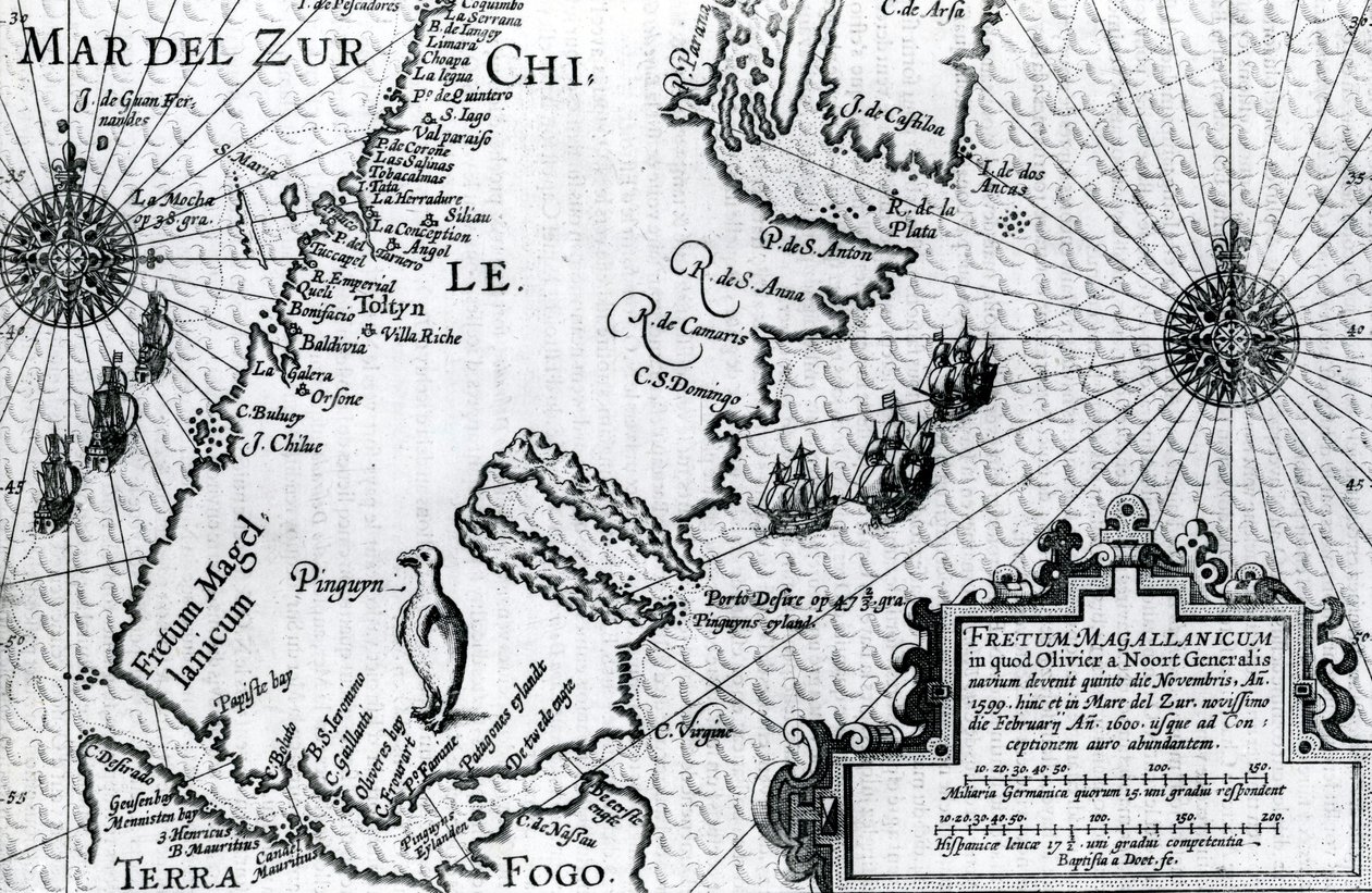
Map of the Strait of Magellan, plate from Oliver van Noort

Map of the Strait of Magellan, plate from Oliver van Noort's Description of His Voyage

(Map of the Strait of Magellan, plate from Oliver van Noorts description of his voyage, 1602 )


Dutch School

€ 119.9
Enthält 0% MwSt.
   Configure art print
1602  ·  engraving  ·  Picture ID: 519965

Cultural Circles  ·  Cartography

Map of the Strait of Magellan, plate from Oliver van Noort's Description of His Voyage by Dutch School. Available as an art print on canvas, photo paper, watercolor board, uncoated paper or Japanese paper.
Private Collection / Bridgeman Images
AR/3D   View in 3D / AR zu Favoriten hinzufügen   Add to favorites    Select wall color    View painting in a room
0 Reviews

Configure art print

Picture Frame

Medium & Stretcher

Glass & Passepartout

Miscellaneous & Extras

 Save / compare configuration
Preview Icon

Summary

Gemälde
Veredelung
Keilrahmen
Museumslizenz

€ 119.9
(inkl. 20% MwSt)
   Add to cart

Bildschärfe: PERFEKT

Should you desire adjustments to brightness and color, or a custom crop of the motif, we are happy to make these changes at no additional cost to you. Please do not hesitate to contact us.

Similar artworks selected for you

Turtle Island and Santo Domingo from a 17th century map by Pierre Vandier Map of the newly discovered Nova Zembla, illustration from Diarium Nauticum, seu vera descriptio trium navigationum admirandarum... by Gerrit de Veer Cape Sagres (or Sacred Cape) at the end of Portugal after the portulan of Luca J. Waghenaer Treesor of zeevaert printed in Leiden in 1592 Linschoten Extreme northeast coastline of the States, in Island of Cuba, Florida and Gulf of Mexico, engraving from Map of Alexander the Great Theatrum Orbis Terrarum Map of Central America and Peru Strait of Magellan, Tierra del Fuego, from Map of Nova Belgica or New Belgium and of Anglia Nova or New England Map of Russia from Theatrum Orbis Terrarum Map of the English Coast between the Isle of Wight and Dover Map of the North Coast of England Near Newcastle upon Tyne Map of the English Coast Between the Isle of Wight and Dover Map of the North Coast of England near Newcastle upon Tyne Map of Livonia Cape Finisterre after the portulan of Luca J. Waghenaer tresoor de zeevaert, Leiden 1592 Map of the Coast of Flanders, Normandy and England Nova Francia (New France) Map of Livonia Die custe va Lijfflandt met de eijlanden daer beneffens New and Accurate Map of the Lands and Kingdoms of California, New Spain, Mexico, and Peru Map of New France Dedicated to Colbert by Duchesneau, Intendant (detail) Map showing location of Brobdingnag from first edition of Gulliver Illustration from the book India Orientalis by unknown author, published by Excudebat Matthaeus Beckerus (Frankfurt, 1598-1628) Bristol Channel Map depicting the East Coast of North America River Orinoco, Rio Amazonas, Venezuela, Northeast Brazil, in Oversize Atlas Titled
Show more similar artworks

Other art prints by Dutch School

Map of New Holland, Now Australia, and of New Zealand A Planisphere with Signs of Zodiac Plaque with a Chinoiserie Landscape and Gilt Details, c.1680 A Dodo Martin Luther preaching (detail) Terrarum Orbis Tabula (after G. a Schagen, c.1689) China Miracle of Our Lady of Nazare, Our Lady of Nazare Church, Portugal The Klencke Atlas, c.1660 Map of Greece, Hungary and Their Surrounding Countries Compass Rose, from a Blaue Atlas, published in Amsterdam Interior of a Dutch House, 1st Half of 17th Century King Alvaro I of Kongo Receiving the Dutch Ambassadors, an Illustration from the Portrait of a Gentleman, early 17th century Title Page of Principia Philosophiae by Rene Descartes
Discover more works by Dutch School

Other motives from the category Cartography

Galathes, 11th King of the Gauls with a map of Gaul behind, detail from a tapestry on the history of the Kings of the Gauls, Arras Workshop, c.1530 Map of Lublin, from Bethlehem (detail) Map of the route taken by Vitus Bering across Siberia to Kamchatka, from Navigantium atque Itinerantium Bibliotheca published 1744 Map of India to New Guinea, c.1570-1603 Map of the Cutch region of India and its border with neighbouring Baluchistan, by Carl Zimmerman, 1851 Reproduction of Map of Routes of St. James of Compostel, Originally Engraved by D. Serveaux 1648 Map of the China Sea, from a Facsimile of the Map of Central Europe, from the Map of Sixteenth Century Egypt, from the Map of the City of Ancient Rome During Its Greatness, BC 30-AD 400 Geographic Map of the Azores Map of the City of Florence Map of the World, Based on Descriptions and Coordinates Given in Map of the Southeastern Part of North America, 1721
View More from "Cartography"

Excerpt from our top sellers

Camelot, illustration from Blue Picture Alpine Hut in Rainy Weather Evening at the Iris Field Moon Over Landscape Valencian Fishermen Flowers in a Crystal Vase Composition VIII, 1915 Caresses, 1896 The River of Light Accent in Rose, 1926 Water Serpents II Battle of Waterloo, 18th June 1815 After the Bath Upwards
Show More Artworks


What our customers think about us


Frequently Asked Questions about Meisterdrucke


Personalizing your art print at Meisterdrucke is a simple and intuitive process that allows you to design an artwork exactly to your specifications: Choose a frame, determine the image size, decide on a printing medium, and add suitable glazing or a stretcher frame. We also offer customization options such as mats, fillets, and spacers. Our customer service is available to help you design your perfect artwork.

At Meisterdrucke, you have the fascinating option to visualize the artwork you configured directly in your own space. For a tailored preview, simply upload a photo of your room and let the artwork appear on it. If you visit us via a mobile device, be it a phone or tablet, our augmented reality feature brings the image to life and seamlessly projects it into your space. An experience that uniquely combines art and technology.

Choosing the medium is often a matter of personal taste. To give you a clearer idea, we have provided some images for each medium. For a holistic experience, we also offer you a sample set of all paper variants so you can make a decision not just visually but also haptically. You can take advantage of the sample set free of charge – only the shipping costs will apply. You can order the sample set directly.

Do not worry. At Meisterdrucke, we do not proceed mechanically. We manually review each order. If there are any inconsistencies or peculiarities in the configuration, we will immediately contact you. Of course, our courteous and patient support is always at your side to assist you with the configuration. Together with you, we adjust your image by phone or email so that the final result exactly meets your expectations.


Do you have any questions?

Are you interested in an art print from our manufactory but still unsure? Do you need advice on choosing the medium or help with the order?

Our experts are happy to assist you.

+43 4257 29415
support@meisterdrucke.com
Mo-Do: 7:00 - 16:00 | Fr: 7:00 - 13:00

Do you have any questions?

Are you interested in an art print from our manufactory but still unsure? Do you need advice on choosing the medium or help with the order?

Our experts are happy to assist you.

+43 4257 29415
support@meisterdrucke.com
Mo-Do: 7:00 - 16:00 | Fr: 7:00 - 13:00


Meisterdrucke

   Kärntner Strasse 46
        9586 Finkenstein am Faaker See
        Austria
        +43 4257 29415
        support@meisterdrucke.com
Other languages

                   
Erfahrungen & Bewertungen zu Meisterdrucke
Post.at DHL Express Quehenberger Cargoboard
Kaiser Franz Joseph

Meisterdrucke
Kärntner Strasse 46
9586 Finkenstein am Faaker See · Austria
+43 4257 29415 · office@meisterdrucke.com
Post.at DHL Express Quehenberger Cargoboard


Meisterdrucke 2752 Bewertungen auf ProvenExpert.com

(c) 2025 meisterdrucke.uk