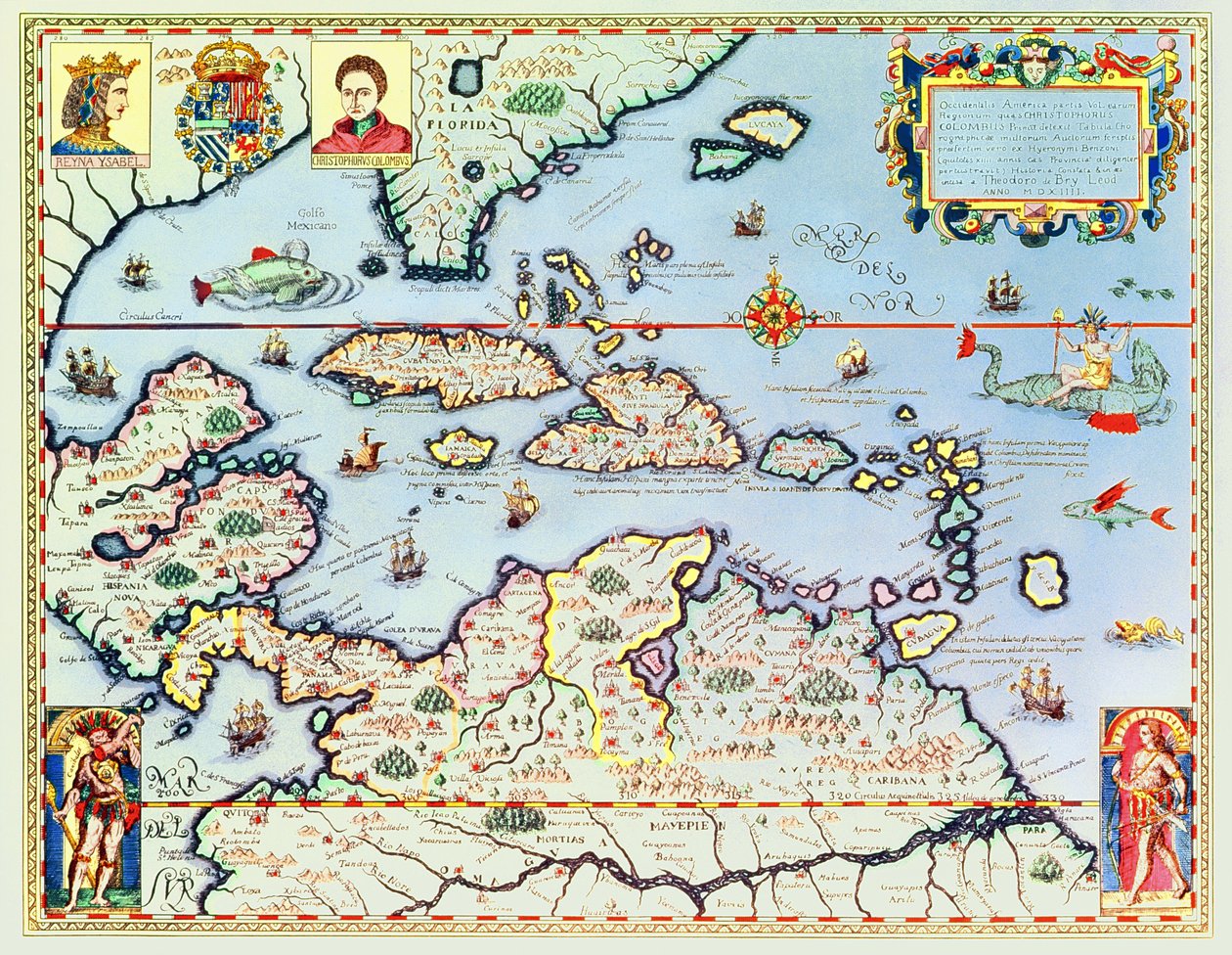
Map of the Caribbean Islands and the American State of Florida by Theodore de Bry

Map of the Caribbean Islands and the American State of Florida

(Map of the Caribbean islands and the American state of Florida )


Theodore de Bry

€ 112.66
Enthält 0% MwSt.
   Configure art print
Undated  ·  coloured engraving  ·  Picture ID: 101030

Nonclassified artists  ·  Cartography

Map of the Caribbean Islands and the American State of Florida by Theodore de Bry. Available as an art print on canvas, photo paper, watercolor board, uncoated paper or Japanese paper.
gulf of mexico · south america · central · north · island · west indies · christopher columbus · discoverer · explorer · portrait · queen isabella · spanish · jamaica · cuba · floride · amerique du sud · antilles · Private Collection / Bridgeman Images
AR/3D   View in 3D / AR zu Favoriten hinzufügen   Add to favorites    Select wall color    View painting in a room
0 Reviews

Configure art print

Picture Frame

Medium & Stretcher

Glass & Passepartout

Miscellaneous & Extras

 Save / compare configuration
Preview Icon

Summary

Gemälde
Veredelung
Keilrahmen
Museumslizenz

€ 112.66
(inkl. 20% MwSt)
   Add to cart

Bildschärfe: PERFEKT

Should you desire adjustments to brightness and color, or a custom crop of the motif, we are happy to make these changes at no additional cost to you. Please do not hesitate to contact us.

Similar artworks selected for you

Slide of Consultation and Public Access Information Investigated from a Book and/or Review Copy Kept in the Bibliographic and Cartographic Collections Northern Europe, from Atlas of the World in thirty-three Maps Map of Zeeland The famous West Indian voyage made by the English Fleet of 23 ships and barks wherein were gotten the towns of St. Iago, Sto Domingo, Cartagena and St. Augustines World map Map of India to New Guinea, c.1570-1603 Map of the Sea of Maluku, from the Cosmographie Universelle Malta A Faithful Reproduction of Carta Marina (A Wallmap of Scandinavia by Olaus Magnus Published in 1539) Map of the island of Malta Eastern India with Borneo and Philippine (engraving) Geography map of East India and South East Asian territory from Pakistan, India, Sri Lanka, Nepal, Bhutan, Bangladesh, South China, Burma, Thailand, Laos, Vietnam, Cambodia, Malaysia, Brunei, Indonesia, The Philippines, Taiwan, South Japan Map of Northern Europe, from Scandinavia (detail) Mainland Southeast Asia, detail from a world atlas Geography Map of the Tartar Territory from Theatrum Orbis Terrarum by Abraham Ortelius Scandinavia, detail from the Carta Marina by Olaus Magnus The Famous West Indian Voyage Made by the English Fleet of 23 Ships and Barks Chart of the English Channel Chart of the Mediterranean, Showing Italy and the North African Coast Dutch Trade Map of the Baltic Sea Map of Livonia Map of Livonia Die custe va Lijfflandt met de eijlanden daer beneffens Map of the Indies, from Theatrum Orbis Terrarum Map of the East Indies, pub. 1635 in Amsterdam From East Africa to the Tip of Ceylon Isle of Rugen, Germany (engraving) Province: Friesland, North Holland, South Holland, North Brabant, Limburg, Utrecht, Gelderland, Flevoland, Netherlands
Show more similar artworks

Other art prints by Theodore de Bry

Sir Walter Raleigh: The Discovery of the Large, Rich and Beautiful Empire of Guiana, from Admiranta Narratio.... Frontispiece (page 1) History of America: the explorer Christopher Columbus is welcomed by the Indians on his arrival in the New World (Engraving by Theodore De Bry) History of America: Tortures inflicted by the Indians on Spanish settlers Scene of Cannibalism in Brazil. Indians devoured their enemies and prisoners. Engraving from Description of Crimes Inflicted on Indians by Spanish Settlers - Spaniards Torturing Indians - Engraving by Theodore de Bry in History of America: Spaniards exploit gold mines. The Indians work before the eyes of the settlers. Engraving by Theodore de Bry (1528-1598). 16th century Private collection The Dogs of Vasco Nunez de Balboa Attacking the Indians Description of Crimes Inflicted on Indians by Spanish Settlers - Scene of Torture of Indians by Spanish Conquistadors. Torture on a Grill, Amputation of Hands - Engraving by Theodore de Bry Gold mine in Potosi, Bolivia Scene of Cannibalism, from Scene of Cannibalism in Brazil in 1644 History of America: First contact of the Italian navigator Amerigo Vespucci with the Indians of America Christopher Columbus, Genoese explorer, discovering America, 12 May 1492 Map of the Caribbean Islands and the American State of Florida
Discover more works by Theodore de Bry

Other motives from the category Cartography

Map of the Old and New Worlds, c.1500 Map of Spain and Portugal Map of Bosnia with Details of the Areas Occupied by Minority Ethnic Groups, 1910 Map of the Siege of Malta in 1565 Map of the Kingdom of Siam Map of Naples, from Map of Sas de Gant and Surrounding Areas Map of the parish of St Giles in the Fields, London Map of Brighton by Thomas Yeakell and William Gardner, engraved by Whitchurch Map of the City of Jerusalem, before 1167 The Polar Aurora, from a Collection of Dutch Marine Maps (detail) Map of Szolnok, from Map of Virginia, discovered and described by Captain John Smith, 1606, engraved by William Hole, published 1612 Map of combat at the Battle of Lubeck, showing positions of the French, Prussian, Swedish and Danish armies Scene of the Zodiac including a Galleon (detail)
View More from "Cartography"

Excerpt from our top sellers

The Luncheon: Monet Olive Trees with Yellow Sky and Sun Autumn Landscape with Four Trees Sack of Rome (455) - The Destiny of Empires - Destruction - by Thomas Cole - 1836- New York Historical Society - (Rome, Roman Empire, Gaiseric, Genseric, Migration Period, Barbarian Invasions, Vandals, Fall of Western Roman Empire, Fall of Rome, Sack of Ro King of the Forest, 1878 Morning amongst the Coniston Fells, Cumberland The Mountain Mowers, First Version The Creation of the World Representing the Cosmic Sphere of the Earth (Back Panels of the Triptych The Dream The Apple Tree The Great Piece of Turf Lisbeth Moonrise Portrait of a Woman, 1910 Woman on the Beach
Show More Artworks


What our customers think about us


Frequently Asked Questions about Meisterdrucke


Personalizing your art print at Meisterdrucke is a simple and intuitive process that allows you to design an artwork exactly to your specifications: Choose a frame, determine the image size, decide on a printing medium, and add suitable glazing or a stretcher frame. We also offer customization options such as mats, fillets, and spacers. Our customer service is available to help you design your perfect artwork.

At Meisterdrucke, you have the fascinating option to visualize the artwork you configured directly in your own space. For a tailored preview, simply upload a photo of your room and let the artwork appear on it. If you visit us via a mobile device, be it a phone or tablet, our augmented reality feature brings the image to life and seamlessly projects it into your space. An experience that uniquely combines art and technology.

Choosing the medium is often a matter of personal taste. To give you a clearer idea, we have provided some images for each medium. For a holistic experience, we also offer you a sample set of all paper variants so you can make a decision not just visually but also haptically. You can take advantage of the sample set free of charge – only the shipping costs will apply. You can order the sample set directly.

Do not worry. At Meisterdrucke, we do not proceed mechanically. We manually review each order. If there are any inconsistencies or peculiarities in the configuration, we will immediately contact you. Of course, our courteous and patient support is always at your side to assist you with the configuration. Together with you, we adjust your image by phone or email so that the final result exactly meets your expectations.


Do you have any questions?

Are you interested in an art print from our manufactory but still unsure? Do you need advice on choosing the medium or help with the order?

Our experts are happy to assist you.

+43 4257 29415
support@meisterdrucke.com
Mo-Do: 7:00 - 16:00 | Fr: 7:00 - 13:00

Do you have any questions?

Are you interested in an art print from our manufactory but still unsure? Do you need advice on choosing the medium or help with the order?

Our experts are happy to assist you.

+43 4257 29415
support@meisterdrucke.com
Mo-Do: 7:00 - 16:00 | Fr: 7:00 - 13:00


Meisterdrucke

   Kärntner Strasse 46
        9586 Finkenstein am Faaker See
        Austria
        +43 4257 29415
        support@meisterdrucke.com
Other languages

                   
Erfahrungen & Bewertungen zu Meisterdrucke
Post.at DHL Express Quehenberger Cargoboard
Kaiser Franz Joseph

Meisterdrucke
Kärntner Strasse 46
9586 Finkenstein am Faaker See · Austria
+43 4257 29415 · office@meisterdrucke.com
Post.at DHL Express Quehenberger Cargoboard


Meisterdrucke hat 4,92 von 5 Sternen 2701 Bewertungen auf ProvenExpert.com

(c) 2025 meisterdrucke.uk