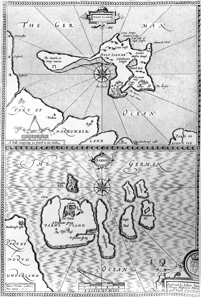
Maps of Holy Island and Farne Island, Northumberland by John Speed

Maps of Holy Island and Farne Island, Northumberland

(Maps of Holy Island and Farne Island, Northumberland, from 'The Theatre of the Empire of Great Britaine' by John Speed, 1676 )


John Speed

€ 126.18
Enthält 0% MwSt.
   Configure art print
1676  ·  Gravur  ·  Picture ID: 77185

Nonclassified artists  ·  Cartography

Maps of Holy Island and Farne Island, Northumberland by John Speed. Available as an art print on canvas, photo paper, watercolor board, uncoated paper or Japanese paper.
Private Collection / Bridgeman Images
AR/3D   View in 3D / AR zu Favoriten hinzufügen   Add to favorites    Select wall color    View painting in a room
0 Reviews

Configure art print

Picture Frame

Medium & Stretcher

Glass & Passepartout

Miscellaneous & Extras

 Save / compare configuration
Preview Icon

Summary

Gemälde
Veredelung
Keilrahmen
Museumslizenz

€ 126.18
(inkl. 20% MwSt)
   Add to cart

Bildschärfe: PERFEKT

Should you desire adjustments to brightness and color, or a custom crop of the motif, we are happy to make these changes at no additional cost to you. Please do not hesitate to contact us.

Similar artworks selected for you

Plan Showing the Strait of Constantinople (now the Strait of Bosphorus) - in Map including Massachusetts Bay Map of Atlantis, from South Part of New England as it is Planted this Year 1634 Map of Lake Ontario with the English and French fleets The Thames Estuary from The Sea-Mirrour atlas by Willem Janszoon Blaeu, published in Amsterdam in 1633 Connecticut Map No.6 showing the route of the Armada fleet, engraved by Augustine Ryther, 1588 Map of Countries First Discovered by Christopher Columbus (1451-1506) 1500 Map of Atlantis, from The Islands of Samoa and Maouna, from the itinerary of La Pérouse Map of the Legendary Island of Atlantis Corsica from the Map of Atlantis, from Bristol Channel Turtle Island and Santo Domingo from a 17th century map by Pierre Vandier Map of the San Juan Archipelago, with the Disputed Channel and Boundary The South Pole, (detail) from the Island of Cuba, Florida and Gulf of Mexico, engraving from Map of an Island in the Treasure (Pirates?) Map of the Island of Zante, a Venetian Stronghold Against the Turks Map of Laputa, Balnibari, Luggnagg, Glubbdubdrib and Japan, illustration from the first edition of Map showing location of the Houyhnhnms Land from first edition of Gulliver Map Showing the route of the Armada fleet, engraved by Augustine Ryther Map of the Isthmus of Darien and the Gulf of Panama in Easter Island, from Travel Atlas by James Cook The Arrival of Vice-Admiral Wybrandt Van Warwijck Map No.9 showing the route of the Armada fleet, engraved by Augustine Ryther, 1588
Show more similar artworks

Other art prints by John Speed

A New and Accurate Map of the World The Turkish Empire Maps of Holy Island and Farne Island, Northumberland Map of Tartary by John Speed Wales, engraved by Jodocus Hondius from John Speed The North and East Ridings of Yorkshire, engraved by Jodocus Hondius from John Speed The Turkish Empire, from The Kingdom of England (engraved by Jodocus Hondius) Suffolk and the Situation of Ipswich, Engraved by Jodocus Hondius from John Speed The Kingdom of Scotland, Engraved by Jodocus Hondius from Map Depicting The Invasions of England and Ireland With All Their Civil Wars Since the Conquest, c.1627 Stafford County and Town, engraved by Jodocus Hondius from John Speed Cumberland and the Ancient City of Carlile Map of Surrey, engraved by Jodocus Hondius from John Speed The Bishoprick and City of Durham, engraved by Jodocus Hondius from John Speed
Discover more works by John Speed

Other motives from the category Cartography

Map of the travels of Abraham, Isaac and Jacob, 1652 Map of Africa, from Nova Africa Descriptio, published in Amsterdam by Dutch cartographer Frederik de Wit Map of the Battle of Trafalgar, published by William Blackwood and Sons, Edinburgh and London Map of the Siege of Quebec by the British Fleet, 1670 Map of Prague, from Map of the Pacific, China and America, 1589 Part of the Tabula Peutingeriana, an illustrated itinerarium of the road network in the Roman Empire. Detail of Italy from the Peutinger map copy Map of the World, 1486 Map of Goa, from Histoire generale des voyages, 1750 Map of Paris at the Outbreak of the French Revolution, published by William Blackwood and Sons Map Showing the New Frontier Line Between Russia and Turkey as Settled by the Treaty, 30 March 1856 Map of Berlin, Published by Carl Glueck Verlag, Berlin, 1860 Map of Regent Street, c.1830 Map of Europe, Published in 1700, Paris Map of the Taking of Tunis by the Spanish in 1573
View More from "Cartography"

Excerpt from our top sellers

Kite Flying The Waterlilies - The Clouds (right side), 1914-18 Cupid and Psyche Isle of the Dead. 1883 (Third Version of Five) Dante and Virgil What Freedom! 1903 Landscape from Saint-Rémy Sunlight in the Blue Room Two Riders on the Beach Standing Female Nude with Blue Cloth Kingfisher by the Waterside One of the Family Old Woman and Boy with Candles Song of the Angels Merry Christmas
Show More Artworks


What our customers think about us


Frequently Asked Questions about Meisterdrucke


Personalizing your art print at Meisterdrucke is a simple and intuitive process that allows you to design an artwork exactly to your specifications: Choose a frame, determine the image size, decide on a printing medium, and add suitable glazing or a stretcher frame. We also offer customization options such as mats, fillets, and spacers. Our customer service is available to help you design your perfect artwork.

At Meisterdrucke, you have the fascinating option to visualize the artwork you configured directly in your own space. For a tailored preview, simply upload a photo of your room and let the artwork appear on it. If you visit us via a mobile device, be it a phone or tablet, our augmented reality feature brings the image to life and seamlessly projects it into your space. An experience that uniquely combines art and technology.

Choosing the medium is often a matter of personal taste. To give you a clearer idea, we have provided some images for each medium. For a holistic experience, we also offer you a sample set of all paper variants so you can make a decision not just visually but also haptically. You can take advantage of the sample set free of charge – only the shipping costs will apply. You can order the sample set directly.

Do not worry. At Meisterdrucke, we do not proceed mechanically. We manually review each order. If there are any inconsistencies or peculiarities in the configuration, we will immediately contact you. Of course, our courteous and patient support is always at your side to assist you with the configuration. Together with you, we adjust your image by phone or email so that the final result exactly meets your expectations.


Do you have any questions?

Are you interested in an art print from our manufactory but still unsure? Do you need advice on choosing the medium or help with the order?

Our experts are happy to assist you.

+43 4257 29415
support@meisterdrucke.com
Mo-Do: 7:00 - 16:00 | Fr: 7:00 - 13:00

Do you have any questions?

Are you interested in an art print from our manufactory but still unsure? Do you need advice on choosing the medium or help with the order?

Our experts are happy to assist you.

+43 4257 29415
support@meisterdrucke.com
Mo-Do: 7:00 - 16:00 | Fr: 7:00 - 13:00


Meisterdrucke

   Kärntner Strasse 46
        9586 Finkenstein am Faaker See
        Austria
        +43 4257 29415
        support@meisterdrucke.com
Other languages

                   
Erfahrungen & Bewertungen zu Meisterdrucke
Post.at DHL Express Quehenberger Cargoboard
Kaiser Franz Joseph

Meisterdrucke
Kärntner Strasse 46
9586 Finkenstein am Faaker See · Austria
+43 4257 29415 · office@meisterdrucke.com
Post.at DHL Express Quehenberger Cargoboard


Meisterdrucke 2707 Bewertungen auf ProvenExpert.com

(c) 2025 meisterdrucke.uk