Search by artist, work title or style – e.g. Monet, Starry Night, Impressionism, Hokusai wave, nude. Describe the scene – e.g. green meadow, abstract with lots of red, dark oil painting, standing nude next to a tree.

Wyld

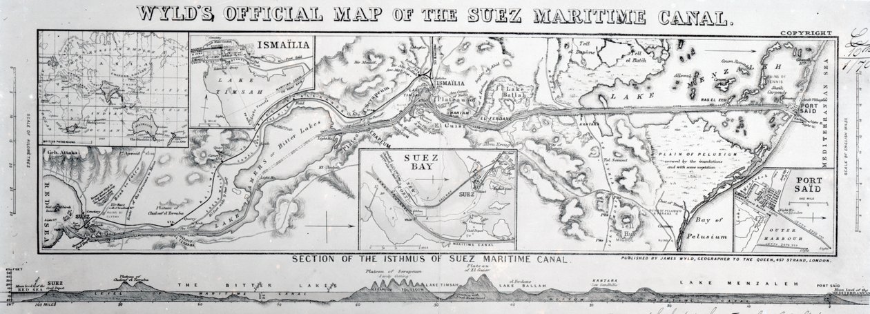
Wyld's Official Map of the Suez Maritime Canal, 1869

(Wyld's Official Map of the Suez Maritime Canal, 1869 )


James the Younger Wyld

€ 86.57
Enthält 0% MwSt.
   Configure art print
1869  ·  Gravur  ·  Picture ID: 99540

Nonclassified artists  ·  Cartography

Wyld's Official Map of the Suez Maritime Canal, 1869 by James the Younger Wyld. Available as an art print on canvas, photo paper, watercolor board, uncoated paper or Japanese paper.
plan · waterway · communications · communication · Private Collection / Bridgeman Images
AR/3D   View in 3D / AR zu Favoriten hinzufügen   Add to favorites    Select wall color    View painting in a room
0 Reviews

Configure art print

Picture Frame

Medium & Stretcher

Glass & Passepartout

Miscellaneous & Extras

 Save / compare configuration
Preview Icon

Summary

Gemälde
Veredelung
Keilrahmen
Museumslizenz

€ 86.57
(inkl. 20% MwSt)
   Add to cart

Bildschärfe: PERFEKT

Should you desire adjustments to brightness and color, or a custom crop of the motif, we are happy to make these changes at no additional cost to you. Please do not hesitate to contact us.

Similar artworks selected for you

Map of the Suez Canal accompanied by different views and portraits of Ferdinand de Lesseps and Ismail Pasha, 1869 Map Showing the Position of the Kingdom of Ely in Malabar, Sketch Showing the Position of Kayal in Tinnevelly Chart of the Suez Canal Part of the Remains of the City of Sarai near Tzarev North of the Akhtuba Branch of the Volga The Harbour of Kagosima, Japan Reduced Admiralty Chart of the Needles Map of the New Simplon Pass, 1803 Tribe of Issachar Entrance to Darra Salaam, by Commander R. Bradshaw, HMS Star Map of the Crimea and the Sea of Azov Sketch Map of the Chitral Campaign Map of the Siege of Mantua, published by William Blackwood and Sons Map of the Old South-Western Sea-Coast Plan of Sir Hope Grant Map of the Island of Jamaica Sketch Plan of the Attack on Ali Musjid Simonoseki Bay, Japan Map of Chinese Turkestan, from Chart of the Sea of Azoff and the Straits of Kertch and Yenikale Map of the Caucasus HM Indian Troop-Ship: Bird Map of the Country between the River Alma and Balaklava, illustrating the Advance of the Allied Armies Sketch Map from the Dardanelles to the Bosphorus Map of the Coast of the Late Wrecks Plan of Portsmouth, Portsea Spithead and Vicinity, by G H Swanston, Edinburgh Map to Illustrate the Geographical Position of the City of Sarai Sketch Plan showing the Military Position in Egypt Map of the Environs of Sevastopol Map of the Country between Auckland and the River Waikato, New Zealand, illustrating the War with the Natives
Show more similar artworks

Other motives from the category Cartography

Map of Sussex East Africa and the Red Sea with Prester John and the Legendary Kings of Africa, detail from a map of the Mediterranean Sea by Vesconte de Maggiolo, 1563 Map of Durham Map of the New Fortifications of Antwerp Map of the Magellan Straits, from Map of Brobdingnag, illustration from the first edition of Map of the Ottoman Empire, Kingdom of Greece, and the Russian Provinces on the Black Sea Map Showing the Geography of the Hebrews and Exhibiting the Dispersion of the Descendants of Noah Map of Lisbon, from A New Map of the Kingdom of England and the Principality of Wales, 1669 Map of Forata and Jeresa from Plan and Map of the Town and Citadel of Mont-Louis Map of Sussex Map of Athens and Its Vicinity; The Acropolis Map of the Gulf of Naples and Surrounding Area from
View More from "Cartography"

Excerpt from our top sellers

Girl with a Rake in Fjord Landscape The Isle of the Dead, Fifth Version, 1886 Small Garden Ghost Judith Beheading Holofernes Lying Dog in the Snow Moonlight over Lake Lucerne The Sleeping Jesus, or Madonna Holding the Sleeping Child, Accompanied by Three Angels The Annunciation, 1474-75 Saturn Devouring His Son Waterlilies at Sunset The Red Tree Trinity The Geographer The Roses of Heliogabalus The Girls
Show More Artworks


What our customers think about us


Frequently Asked Questions about Meisterdrucke


Personalizing your art print at Meisterdrucke is a simple and intuitive process that allows you to design an artwork exactly to your specifications: Choose a frame, determine the image size, decide on a printing medium, and add suitable glazing or a stretcher frame. We also offer customization options such as mats, fillets, and spacers. Our customer service is available to help you design your perfect artwork.

At Meisterdrucke, you have the fascinating option to visualize the artwork you configured directly in your own space. For a tailored preview, simply upload a photo of your room and let the artwork appear on it. If you visit us via a mobile device, be it a phone or tablet, our augmented reality feature brings the image to life and seamlessly projects it into your space. An experience that uniquely combines art and technology.

Choosing the medium is often a matter of personal taste. To give you a clearer idea, we have provided some images for each medium. For a holistic experience, we also offer you a sample set of all paper variants so you can make a decision not just visually but also haptically. You can take advantage of the sample set free of charge – only the shipping costs will apply. You can order the sample set directly.

Do not worry. At Meisterdrucke, we do not proceed mechanically. We manually review each order. If there are any inconsistencies or peculiarities in the configuration, we will immediately contact you. Of course, our courteous and patient support is always at your side to assist you with the configuration. Together with you, we adjust your image by phone or email so that the final result exactly meets your expectations.


Do you have any questions?

Are you interested in an art print from our manufactory but still unsure? Do you need advice on choosing the medium or help with the order?

Our experts are happy to assist you.

+43 4257 29415
support@meisterdrucke.com
Mo-Do: 7:00 - 16:00 | Fr: 7:00 - 13:00

Do you have any questions?

Are you interested in an art print from our manufactory but still unsure? Do you need advice on choosing the medium or help with the order?

Our experts are happy to assist you.

+43 4257 29415
support@meisterdrucke.com
Mo-Do: 7:00 - 16:00 | Fr: 7:00 - 13:00


Meisterdrucke

   Kärntner Strasse 46
        9586 Finkenstein am Faaker See
        Austria
        +43 4257 29415
        support@meisterdrucke.com
Other languages

                   
Erfahrungen & Bewertungen zu Meisterdrucke
Post.at DHL Express Quehenberger Cargoboard
Kaiser Franz Joseph

Meisterdrucke
Kärntner Strasse 46
9586 Finkenstein am Faaker See · Austria
+43 4257 29415 · office@meisterdrucke.com
Post.at DHL Express Quehenberger Cargoboard


Meisterdrucke 2736 Bewertungen auf ProvenExpert.com

(c) 2025 meisterdrucke.uk