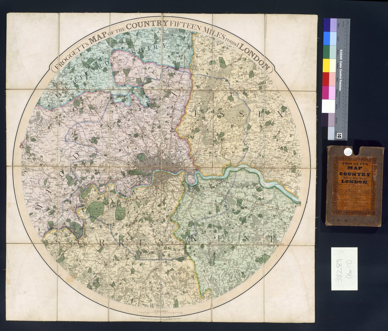
Froggett

Froggett's Map of the Country Fifteen Miles Around London

(Froggett's Map of the Country Fifteen Miles around London, 1833 )


English School

€ 107.9
Enthält 0% MwSt.
   Configure art print
1833  ·  colour lithograph  ·  Picture ID: 96519

Cultural Circles  ·  Cartography

Froggett's Map of the Country Fifteen Miles Around London by English School. Available as an art print on canvas, photo paper, watercolor board, uncoated paper or Japanese paper.
cartography · mapping · geography · geographical · england · roundel · Private Collection / Bridgeman Images
zu Favoriten hinzufügen   Add to favorites    Select wall color    View painting in a room AR/3D   View in 3D / AR
0 Reviews

Configure art print

Picture Frame

Medium & Stretcher

Glass & Passepartout

Miscellaneous & Extras

 Save / compare configuration
Preview Icon

Summary

Gemälde
Veredelung
Keilrahmen
Museumslizenz

€ 107.9
(inkl. 20% MwSt)
   Add to cart

Bildschärfe: PERFEKT

Should you desire adjustments to brightness and color, or a custom crop of the motif, we are happy to make these changes at no additional cost to you. Please do not hesitate to contact us.

Similar artworks selected for you

An Ordinance Survey of London Map of London Fairburn Mogg Topographic Map of One Hundred Square Miles around Berlin Map of the Forest and Manor of Fecknam Fecknam Manor, Worcester, 1744 Map of Leeds, surveyed by John Tuke Map of the Gujarat state of India, published under the direction of Colonel J.T. Walker, Surveyor General of India Sidney A Topographical Map of the County of Sussex, divided into Rapes, Deanries, and Hundreds. Planned from an actual Survey by a scale of one inch to a statute mile Map of the Parish or Borough of Leeds Bavarian Land Tables of 1568 (Table 15) Bavarian Maps of 1568 An 18th Century Map of London. An Exact Survey of the Cities of London, Westminster, the Borough of Southwark and the Country Near Ten Miles Around Begun in 1741 & Ended in 1745 by John Rocque Land Surveyor & Engraved by Richard Parr General Map of Nizhny Novgorod Governorate, 1788 General Map of Nizhny Novgorod Governorate Friesland, Groningen, Netherlands Map of Hertfordshire Transisalania Province Commonly Over-Yssel Talliss Illustrated Plan of London and its Environs, in Commemoration of the Great Exhibition of Industry of all Nations, 1851, published by John Tallis & Co. Map of Friesland New Map of the Land of Utrecht by Order of the Ed. Mog. Heeren Staten Map of Postroads in the vicinity of London Alsatia, Germany (engraving) Map of Artois (France) and Flanders (Belgium, Netherlands) (engraving) Siege of Leuven by the Dutch and French armies Bavarian Land Tables of 1568 (Table 10) Ground Plan of Berlin and Its Immediate Surroundings
Show more similar artworks

Other art prints by English School

Church and Cottage with Lighted Windows The Nonpareil with Portraits of Queen Victoria and Prince Albert Woman beating her husband with a shoe Portrait of a bodybuilder English Rose English Rose Lavater Lee and Sons, acrobats The Great Green Tree Frog Elephant (engraving) Princes Street Edinburgh - West End Roman Augurs View of the Acropolis of Athens Ships Arriving Map of Europe in 1910
Discover more works by English School

Other motives from the category Cartography

A Map of Chelsea, 1746 A Map inspired by Candide by Francois Voltaire for a competition organised by the Ecole Nationale des Ponts et Chaussees in Paris Map Depicting the North of Africa, from an Atlas by Ptolemy, 1st Half 16th Century A Map of Shoreditch and Whitechapel, London, 1746 Part of the Tabula Peutingeriana, an illustrated itinerarium of the road network in the Roman Empire. Detail of Italy from the Peutinger map copy Map, from The Navigation of King James V, Round Scotland, the Orkney Isles, and the Hebrides or Western Isles: Under the Conduct of That Excellent Pilot Alexander Lindsay Map of Palestine, Palestina Antiqua, from Map Showing the Military Campaigns of Louis XIV in the Low Countries, from Atlas Géographique et Militaire, Published in Paris, 1763 Map of Le Marais, Paris Map of the New Discoveries to the North of the South Seas, 1750 Londinium Antiqua, map of London, published by William Darton, 1563 Map of Toledo, from Map of Europe at the Time of the Third Crusade, 1190, from Map of the Northern Sky with Representations of the Constellations Map of the Battle of Borodino, Published by William Blackwood and Sons, Edinburgh and London, 1848
View More from "Cartography"

Excerpt from our top sellers

Garden in Giverny Nocturne in Black and Gold, the Falling Rocket Two Reclining Figures Allegorical Frontispiece of Rome and Its History Sadko View of the Dents-du-Midi from Champéry Road at La Cavée, Pourville Quai du Louvre Tierfabel: Tiger and Snake in Combat in a Primeval Forest The Chocolate Girl (La Belle Chocolatière de Vienne) The Tree of Life (Central Panel) Water Lilies Portrait of a Woman, 1910 Irises Oriental Nude
Show More Artworks


What our customers think about us


Frequently Asked Questions about Meisterdrucke


Personalizing your art print at Meisterdrucke is a simple and intuitive process that allows you to design an artwork exactly to your specifications: Choose a frame, determine the image size, decide on a printing medium, and add suitable glazing or a stretcher frame. We also offer customization options such as mats, fillets, and spacers. Our customer service is available to help you design your perfect artwork.

At Meisterdrucke, you have the fascinating option to visualize the artwork you configured directly in your own space. For a tailored preview, simply upload a photo of your room and let the artwork appear on it. If you visit us via a mobile device, be it a phone or tablet, our augmented reality feature brings the image to life and seamlessly projects it into your space. An experience that uniquely combines art and technology.

Choosing the medium is often a matter of personal taste. To give you a clearer idea, we have provided some images for each medium. For a holistic experience, we also offer you a sample set of all paper variants so you can make a decision not just visually but also haptically. You can take advantage of the sample set free of charge – only the shipping costs will apply. You can order the sample set directly.

Do not worry. At Meisterdrucke, we do not proceed mechanically. We manually review each order. If there are any inconsistencies or peculiarities in the configuration, we will immediately contact you. Of course, our courteous and patient support is always at your side to assist you with the configuration. Together with you, we adjust your image by phone or email so that the final result exactly meets your expectations.


Do you have any questions?

Are you interested in an art print from our manufactory but still unsure? Do you need advice on choosing the medium or help with the order?

Our experts are happy to assist you.

+43 4257 29415
support@meisterdrucke.com
Mo-Do: 7:00 - 16:00 | Fr: 7:00 - 13:00

Do you have any questions?

Are you interested in an art print from our manufactory but still unsure? Do you need advice on choosing the medium or help with the order?

Our experts are happy to assist you.

+43 4257 29415
support@meisterdrucke.com
Mo-Do: 7:00 - 16:00 | Fr: 7:00 - 13:00


Meisterdrucke

   Kärntner Strasse 46
        9586 Finkenstein am Faaker See
        Austria
        +43 4257 29415
        support@meisterdrucke.com
Other languages

                   
Erfahrungen & Bewertungen zu Meisterdrucke
Partner Logos

Kaiser Franz Joseph

Meisterdrucke
Kärntner Strasse 46
9586 Finkenstein am Faaker See · Austria
+43 4257 29415 · office@meisterdrucke.com
Partner Logos


(c) 2025 meisterdrucke.uk